Serralada: Goonies, Avi Miquel, Ave Cesar, Mas Ram

MTB
MTB
Ref..: 912763
Published: 21/10/2020
Performed: 21/10/2020
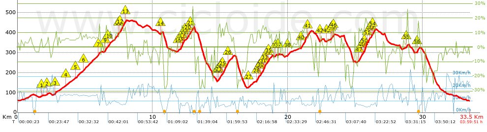
Distance in Km: 33.47
Climb in m: 1340
IBP: 115 BYC

silvesterbike
396 published routes

Add to my Group or Club

 Height in m      Climb in %      Speed in Km/h      Speed < 2 Km/h

Climbs > 5%

Climbs >5% Climbs >10% Climbs >15% Climbs >20% Climbs >25%
 Steep slope of 97 m.   Average slope  Distances  Download as waypoint
1
 Km 1.723  6%  97 m
 Steep slope of 126 m.  Average slope  Distances  Download as waypoint
2
 Km 2.175  6%  126 m
 Steep slope of 313 m.  Average slope  Distances  Download as waypoint
3
 Km 2.739  7%  313 m
 Steep slope of 241 m.  Average slope  Distances  Download as waypoint
4
 Km 3.532  6%  241 m
 Steep slope of 520 m.  Average slope  Distances  Download as waypoint
5
 Km 4.247  6%  520 m
 Steep slope of 1195 m.  Average slope  Distances  Download as waypoint
6
 Km 4.888  7%  1091 m
7
 Km 5.979  17%  104 m
 Steep slope of 947 m.  Average slope  Distances  Download as waypoint
8
 Km 6.443  6%  38 m
9
 Km 6.481  14%  120 m
10
 Km 6.601  8%  789 m
 Steep slope of 600 m.  Average slope  Distances  Download as waypoint
11
 Km 7.511  8%  34 m
12
 Km 7.546  13%  411 m
13
 Km 7.957  9%  155 m
 Steep slope of 112 m.  Average slope  Distances  Download as waypoint
14
 Km 10.586  9%  112 m
 Steep slope of 502 m.  Average slope  Distances  Download as waypoint
15
 Km 11.914  7%  141 m
16
 Km 12.055  11%  72 m
17
 Km 12.127  17%  108 m
18
 Km 12.235  12%  105 m
19
 Km 12.34  7%  76 m
 Steep slope of 459 m.  Average slope  Distances  Download as waypoint
20
 Km 12.52  11%  243 m
21
 Km 12.763  10%  216 m
 Steep slope of 1108 m.  Average slope  Distances  Download as waypoint
22
 Km 14.795  6%  48 m
23
 Km 14.843  13%  190 m
24
 Km 15.033  6%  105 m
25
 Km 15.138  13%  437 m
26
 Km 15.574  9%  328 m
 Steep slope of 327 m.  Average slope  Distances  Download as waypoint
27
 Km 17.111  7%  327 m
 Steep slope of 1121 m.  Average slope  Distances  Download as waypoint
28
 Km 17.681  13%  195 m
29
 Km 17.876  7%  118 m
30
 Km 17.994  10%  140 m
31
 Km 18.134  16%  125 m
32
 Km 18.259  16%  46 m
33
 Km 18.304  12%  149 m
34
 Km 18.453  11%  147 m
35
 Km 18.6  9%  201 m
 Steep slope of 120 m.  Average slope  Distances  Download as waypoint
36
 Km 19.023  6%  120 m
 Steep slope of 135 m.  Average slope  Distances  Download as waypoint
37
 Km 19.277  8%  135 m
 Steep slope of 195 m.  Average slope  Distances  Download as waypoint
38
 Km 20.006  9%  195 m
 Steep slope of 737 m.  Average slope  Distances  Download as waypoint
39
 Km 20.974  8%  39 m
40
 Km 21.014  13%  446 m
41
 Km 21.46  10%  252 m
 Steep slope of 149 m.  Average slope  Distances  Download as waypoint
42
 Km 22.388  8%  149 m
 Steep slope of 113 m.  Average slope  Distances  Download as waypoint
43
 Km 22.895  5%  113 m
 Steep slope of 270 m.  Average slope  Distances  Download as waypoint
44
 Km 23.177  8%  109 m
45
 Km 23.287  11%  120 m
46
 Km 23.407  7%  41 m
 Steep slope of 1225 m.  Average slope  Distances  Download as waypoint
47
 Km 25.219  11%  211 m
48
 Km 25.431  11%  149 m
49
 Km 25.58  14%  71 m
50
 Km 25.652  18%  235 m
51
 Km 25.887  14%  147 m
52
 Km 26.034  8%  117 m
53
 Km 26.151  12%  108 m
54
 Km 26.259  10%  187 m
 Steep slope of 99 m.  Average slope  Distances  Download as waypoint
55
 Km 28.772  13%  99 m
 Steep slope of 74 m.  Average slope  Distances  Download as waypoint
56
 Km 29.605  17%  74 m


Description of the route


Presence of ramps


 Climbs  Distance  % of the total  Speed  Your speed would be  Time  Your time would be
   15 - 30%  1.265  3.78  6.73  ?  0:11:17  ?
   10 - 15%  3.579  10.69  8.32  ?  0:25:49  ?
   5 - 10%  6.927  20.7  10.76  ?  0:38:37  ?
   1 - 5%  5.567  16.63  13.12  ?  0:25:27  ?
   Total*  17.339 Km  51.81 %  10.28 Km/h  ? Km/h    1:41:10 h  ? h  
 Flat
   1 - -1%  2.987 Km  8.93 %  13.66 Km/h  ? Km/h    0:13:07 h  ? h  
 Descents
   -1 - -5%  4.766  14.24  15.02  ?  0:19:02  ?
   -5 - -10%  3.218  9.61  15.61  ?  0:12:22  ?
   -10 - -15%  1.812  5.41  15.13  ?  0:07:11  ?
   -15 - -30%  3.354  10.02  8.8  ?  0:22:52  ?
   Total*  13.15 Km  39.29 %  12.84 Km/h  ? Km/h    1:01:27 h  ? h  
* The total has not necessarily coincide with the sum of the partials after correction of errors

How long would it take you?

How long would it take you to cover this route?
There are routes without a valid time information, but with your average stats you can assess the possible duration

silvesterbike to cover this route you've need a time of:   2:55:44 h 
If you sign in and have a minimum of two tracks of this same modality, you can know your time for this route, calculated from your stats..


¿Cuanto consumirá tu E-BIKE?

Entra tu E-IBP (formato n,nn)

E-IBP :   X 115 = 


 Detected activity type =  ()
 Penalization due to track conditions: 72 %   ( > 50 % = MTB, < 50 % = RDB)
 Reliability of the track: B   (1347/68/0/-/-/68)
 Correction level applied to the track: 0
DIFFICULTY OF THE ROUTE
IBP = 115 BYC
According to your statistics
 Your time in motion would be: ? h
Your average speed would be: ? Km/h
 

 Total Distance: 33.47 Km
 Analysed distance: 33.47 Km
 Linear distance: 0.01 Km

 Cumulated positive ramps: 1340 m  list of points info
 Cumulated negative ramps: 1338.36 m
 Maximum height: 463.4 m
 Minimum height: 57.9 m
 Climbing Ratio: 7.73 %
 Descent ratio: 10.18 %
 Cumulated postive ramps per Km: 40.04 m
 Cumulated negative ramps per Km: 39.99 m

 Total time: 3:59:51 h
 Time in movement: 2:55:44 h
 According to your statistics
 Your time in motion would be: ? h  
 Stopped time: 1:04:07 h
 Maximum slope filter: ~30 %
 Minimum separation analysed: ~30 m
 Number of points: 1830   (cad. 18.29 m)
 Significant waypoints: 847   (cad. 39.56 m / 46.28 %)

 Changes in direction per Km: 12.01
 Changes in direction > 5º por Km: 10.16
 Cumulated straight stretches: 4.278 Km
 Straight stretches per Km: 127.82 m
 Penalized slope changes: 13
 Penalized slope changes per Km: 0.388

 Average speed in total: 8.37 Km/h
 Average speed while moving: 11.43 Km/h
 According to your statistics
 Your average speed would be: ? Km/h  
 Maximum sustained speed: 37.35 Km/h


Comments

You can be the first one in commenting this route

 
My comments
:
Add comment  (Registered users)
 
Notify me answers to my comment  Do not notify answers to my comment


Share this route with a friend

Your friend will receive a message with a link to this page:
will see your email and your user name if you do it as registered user.


Write here your name (optional)

E-mail address of your friend(s). You can include various addresses separated by commas

Text or comment (optional) maximum 255 characters long, 255 Available characters

As a non registered users you need to fill-in the captcha text.
  Change image
Type the image characters.
 
 Share with a friend


Visited history

Delete history

Marked routes for review later or compare

My favorites


  Notify anomaly in this route Share in Facebook