92ªsalida,2020____con El trainer Fran,y J.Eguilaz,berriozar,ororbia,pto del perdon,gares,mañeru,pto ...

Road
Road
Ref..: 909529
Published: 09/10/2020
Performed: 08/10/2020
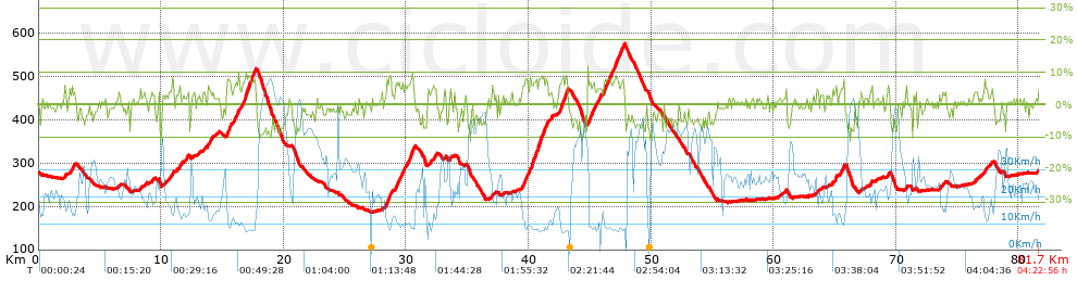
Distance in Km: 81.71
Climb in m: 1329
IBP: 77 BYC

Near ...
Ballariain, Berrioplano, Berriosuso, Elcarte, Orkoien, Oteiza De Berrioplano

 Height in m      Climb in %      Speed in Km/h      Speed < 2 Km/h

Climbs > 5%

Climbs >5% Climbs >10% Climbs >15% Climbs >20% Climbs >25%
 Steep slope of 201 m.   Average slope  Distances  Download as waypoint
1
 Km 2.667  5%  201 m
 Steep slope of 102 m.  Average slope  Distances  Download as waypoint
2
 Km 10.875  5%  102 m
 Steep slope of 134 m.  Average slope  Distances  Download as waypoint
3
 Km 11.519  5%  134 m
 Steep slope of 129 m.  Average slope  Distances  Download as waypoint
4
 Km 12.05  5%  129 m
 Steep slope of 342 m.  Average slope  Distances  Download as waypoint
5
 Km 15.378  8%  342 m
 Steep slope of 391 m.  Average slope  Distances  Download as waypoint
6
 Km 15.957  6%  391 m
 Steep slope of 1081 m.  Average slope  Distances  Download as waypoint
7
 Km 16.577  8%  1081 m
 Steep slope of 422 m.  Average slope  Distances  Download as waypoint
8
 Km 28.372  7%  422 m
 Steep slope of 636 m.  Average slope  Distances  Download as waypoint
9
 Km 29.128  6%  636 m
 Steep slope of 524 m.  Average slope  Distances  Download as waypoint
10
 Km 30.139  7%  524 m
 Steep slope of 90 m.  Average slope  Distances  Download as waypoint
11
 Km 32.393  7%  90 m
 Steep slope of 487 m.  Average slope  Distances  Download as waypoint
12
 Km 39.55  6%  487 m
 Steep slope of 1425 m.  Average slope  Distances  Download as waypoint
13
 Km 40.148  8%  1425 m
 Steep slope of 692 m.  Average slope  Distances  Download as waypoint
14
 Km 42.54  8%  692 m
 Steep slope of 532 m.  Average slope  Distances  Download as waypoint
15
 Km 44.829  7%  532 m
 Steep slope of 114 m.  Average slope  Distances  Download as waypoint
16
 Km 45.462  5%  114 m
 Steep slope of 198 m.  Average slope  Distances  Download as waypoint
17
 Km 45.674  5%  198 m
 Steep slope of 408 m.  Average slope  Distances  Download as waypoint
18
 Km 46.135  7%  408 m
 Steep slope of 793 m.  Average slope  Distances  Download as waypoint
19
 Km 46.644  7%  793 m
 Steep slope of 295 m.  Average slope  Distances  Download as waypoint
20
 Km 47.539  7%  295 m
 Steep slope of 158 m.  Average slope  Distances  Download as waypoint
21
 Km 65.065  7%  158 m
 Steep slope of 112 m.  Average slope  Distances  Download as waypoint
22
 Km 65.655  7%  112 m
 Steep slope of 123 m.  Average slope  Distances  Download as waypoint
23
 Km 67.892  6%  123 m


Description of the route


Presence of ramps


 Climbs  Distance  % of the total  Speed  Your speed would be  Time  Your time would be
   15 - 30%  0  0  0  ?  0:00:00  ?
   10 - 15%  0.307  0.38  10.22  ?  0:01:48  ?
   5 - 10%  10.445  12.78  10.68  ?  0:58:40  ?
   1 - 5%  21.735  26.6  18.63  ?  1:10:00  ?
   Total*  32.487 Km  39.76 %  14.94 Km/h  ? Km/h    2:10:28 h  ? h  
 Flat
   1 - -1%  18.295 Km  22.39 %  23.26 Km/h  ? Km/h    0:47:12 h  ? h  
 Descents
   -1 - -5%  19.067  23.34  28.84  ?  0:39:40  ?
   -5 - -10%  11.488  14.06  39.77  ?  0:17:20  ?
   -10 - -15%  0.373  0.46  37.29  ?  0:00:36  ?
   -15 - -30%  0  0  0  ?  0:00:00  ?
   Total*  30.928 Km  37.85 %  32.22 Km/h  ? Km/h    0:57:36 h  ? h  
* The total has not necessarily coincide with the sum of the partials after correction of errors

How long would it take you?

How long would it take you to cover this route?
There are routes without a valid time information, but with your average stats you can assess the possible duration

???Juan_Jose_Cuadros_P.(el_Puryto_Espi)??????_C.P. to cover this route you've need a time of:   3:55:16 h 
If you sign in and have a minimum of two tracks of this same modality, you can know your time for this route, calculated from your stats..


¿Cuanto consumirá tu E-BIKE?

Entra tu E-IBP (formato n,nn)

E-IBP :   X 77 = 


 Detected activity type =  ()
 Penalization due to track conditions: 34 %   ( > 50 % = MTB, < 50 % = RDB)
 Reliability of the track: B   (1329/59/0/-/-/59)
 Correction level applied to the track: 0
DIFFICULTY OF THE ROUTE
IBP = 77 BYC
According to your statistics
 Your time in motion would be: ? h
Your average speed would be: ? Km/h
 

 Total Distance: 81.71 Km
 Analysed distance: 81.71 Km
 Linear distance: 0.05 Km

 Cumulated positive ramps: 1329.4 m  list of points info
 Cumulated negative ramps: 1334.4 m
 Maximum height: 574.6 m
 Minimum height: 186.4 m
 Climbing Ratio: 4.09 %
 Descent ratio: 4.31 %
 Cumulated postive ramps per Km: 16.27 m
 Cumulated negative ramps per Km: 16.33 m

 Total time: 4:22:56 h
 Time in movement: 3:55:16 h
 According to your statistics
 Your time in motion would be: ? h  
 Stopped time: 0:27:40 h
 Maximum slope filter: ~30 %
 Minimum separation analysed: ~30 m
 Number of points: 3344   (cad. 24.43 m)
 Significant waypoints: 1987   (cad. 41.12 m / 59.42 %)

 Changes in direction per Km: 7.45
 Changes in direction > 5º por Km: 3.1
 Cumulated straight stretches: 38.94 Km
 Straight stretches per Km: 476.56 m
 Penalized slope changes: 14
 Penalized slope changes per Km: 0.171

 Average speed in total: 18.65 Km/h
 Average speed while moving: 20.84 Km/h
 According to your statistics
 Your average speed would be: ? Km/h  
 Maximum sustained speed: 65.24 Km/h


Comments

You can be the first one in commenting this route

 
My comments
:
Add comment  (Registered users)
 
Notify me answers to my comment  Do not notify answers to my comment


Share this route with a friend

Your friend will receive a message with a link to this page:
will see your email and your user name if you do it as registered user.


Write here your name (optional)

E-mail address of your friend(s). You can include various addresses separated by commas

Text or comment (optional) maximum 255 characters long, 255 Available characters

As a non registered users you need to fill-in the captcha text.
  Change image
Type the image characters.
 
 Share with a friend


Visited history

Delete history

Marked routes for review later or compare

My favorites


  Notify anomaly in this route Share in Facebook