Barcelona (Barcelona)

MTB
MTB
Ref..: 908137
Published: 03/10/2020
Performed: 03/10/2020
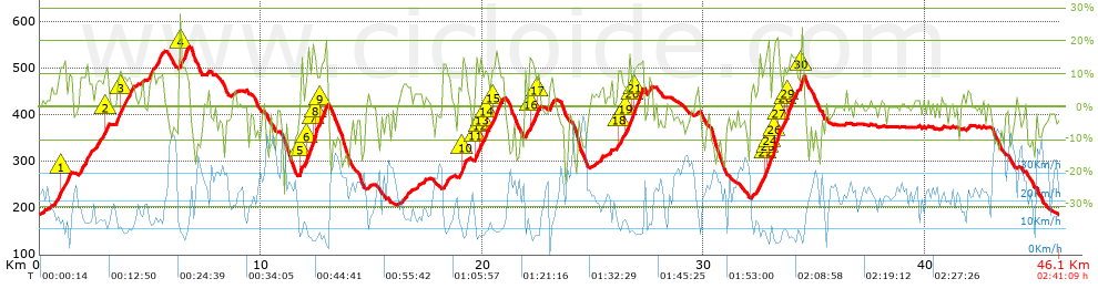
Distance in Km: 46.08
Climb in m: 1460
IBP: 123 BYC

Javi Mora
Author: Javi Mora
257 published routes

Add to my Group or Club

 Height in m      Climb in %      Speed in Km/h      Speed < 2 Km/h

Climbs > 5%

Climbs >5% Climbs >10% Climbs >15% Climbs >20% Climbs >25%
 Steep slope of 656 m.   Average slope  Distances  Download as waypoint
1
 Km 0.775  8%  173 m
2
 Km 0.947  11%  133 m
3
 Km 1.08  9%  116 m
4
 Km 1.197  9%  93 m
5
 Km 1.29  9%  141 m
 Steep slope of 598 m.  Average slope  Distances  Download as waypoint
6
 Km 1.787  8%  598 m
 Steep slope of 587 m.  Average slope  Distances  Download as waypoint
7
 Km 2.529  8%  479 m
8
 Km 3.008  13%  108 m
 Steep slope of 859 m.  Average slope  Distances  Download as waypoint
9
 Km 3.453  10%  187 m
10
 Km 3.64  11%  132 m
11
 Km 3.772  9%  540 m
 Steep slope of 124 m.  Average slope  Distances  Download as waypoint
12
 Km 4.608  6%  124 m
 Steep slope of 693 m.  Average slope  Distances  Download as waypoint
13
 Km 4.932  9%  693 m
 Steep slope of 423 m.  Average slope  Distances  Download as waypoint
14
 Km 6.335  13%  304 m
15
 Km 6.639  10%  119 m
 Steep slope of 1200 m.  Average slope  Distances  Download as waypoint
16
 Km 11.753  14%  127 m
17
 Km 11.88  6%  195 m
18
 Km 12.075  13%  255 m
19
 Km 12.33  15%  173 m
20
 Km 12.503  13%  84 m
21
 Km 12.587  9%  117 m
22
 Km 12.704  14%  249 m
 Steep slope of 390 m.  Average slope  Distances  Download as waypoint
23
 Km 16.411  6%  390 m
 Steep slope of 390 m.  Average slope  Distances  Download as waypoint
24
 Km 18.248  7%  390 m
 Steep slope of 429 m.  Average slope  Distances  Download as waypoint
25
 Km 18.926  7%  152 m
26
 Km 19.079  13%  189 m
27
 Km 19.267  5%  88 m
 Steep slope of 1271 m.  Average slope  Distances  Download as waypoint
28
 Km 19.688  13%  139 m
29
 Km 19.827  10%  96 m
30
 Km 19.923  11%  97 m
31
 Km 20.02  9%  102 m
32
 Km 20.123  12%  145 m
33
 Km 20.267  6%  179 m
34
 Km 20.447  12%  296 m
35
 Km 20.743  10%  217 m
 Steep slope of 663 m.  Average slope  Distances  Download as waypoint
36
 Km 21.885  6%  254 m
37
 Km 22.139  12%  213 m
38
 Km 22.352  9%  115 m
39
 Km 22.467  13%  81 m
 Steep slope of 264 m.  Average slope  Distances  Download as waypoint
40
 Km 23.026  8%  264 m
 Steep slope of 128 m.  Average slope  Distances  Download as waypoint
41
 Km 25.374  7%  128 m
 Steep slope of 1126 m.  Average slope  Distances  Download as waypoint
42
 Km 26.085  5%  64 m
43
 Km 26.149  11%  142 m
44
 Km 26.292  8%  199 m
45
 Km 26.491  11%  318 m
46
 Km 26.809  11%  97 m
47
 Km 26.906  13%  306 m
 Steep slope of 197 m.  Average slope  Distances  Download as waypoint
48
 Km 27.462  8%  197 m
 Steep slope of 176 m.  Average slope  Distances  Download as waypoint
49
 Km 32.177  5%  176 m
 Steep slope of 529 m.  Average slope  Distances  Download as waypoint
50
 Km 32.495  10%  245 m
51
 Km 32.741  11%  105 m
52
 Km 32.846  18%  140 m
53
 Km 32.986  16%  39 m
 Steep slope of 1106 m.  Average slope  Distances  Download as waypoint
54
 Km 33.126  15%  40 m
55
 Km 33.165  17%  245 m
56
 Km 33.411  12%  117 m
57
 Km 33.528  8%  88 m
58
 Km 33.615  10%  142 m
59
 Km 33.757  14%  157 m
60
 Km 33.914  9%  215 m
61
 Km 34.13  14%  102 m
 Steep slope of 145 m.  Average slope  Distances  Download as waypoint
62
 Km 34.346  8%  38 m
63
 Km 34.384  24%  107 m


Description of the route


Presence of ramps


 Climbs  Distance  % of the total  Speed  Your speed would be  Time  Your time would be
   15 - 30%  1.358  2.95  7.18  ?  0:11:21  ?
   10 - 15%  4.545  9.86  9.32  ?  0:29:15  ?
   5 - 10%  6.638  14.41  12.43  ?  0:32:02  ?
   1 - 5%  6.424  13.94  18.02  ?  0:21:23  ?
   Total*  18.966 Km  41.16 %  12.1 Km/h  ? Km/h    1:34:01 h  ? h  
 Flat
   1 - -1%  7.136 Km  15.49 %  20.36 Km/h  ? Km/h    0:21:02 h  ? h  
 Descents
   -1 - -5%  8.66  18.79  25.18  ?  0:20:38  ?
   -5 - -10%  5.364  11.64  25.61  ?  0:12:34  ?
   -10 - -15%  4.176  9.06  28.26  ?  0:08:52  ?
   -15 - -30%  1.782  3.87  26.51  ?  0:04:02  ?
   Total*  19.981 Km  43.36 %  26.01 Km/h  ? Km/h    0:46:06 h  ? h  
* The total has not necessarily coincide with the sum of the partials after correction of errors

How long would it take you?

How long would it take you to cover this route?
There are routes without a valid time information, but with your average stats you can assess the possible duration

Javi Mora to cover this route you've need a time of:   2:41:09 h 
If you sign in and have a minimum of two tracks of this same modality, you can know your time for this route, calculated from your stats..


¿Cuanto consumirá tu E-BIKE?

Entra tu E-IBP (formato n,nn)

E-IBP :   X 123 = 


 Detected activity type =  ()
 Penalization due to track conditions: 68 %   ( > 50 % = MTB, < 50 % = RDB)
 Reliability of the track: A   (1465/76/0/-/-/76)
 Correction level applied to the track: 0
DIFFICULTY OF THE ROUTE
IBP = 123 BYC
According to your statistics
 Your time in motion would be: ? h
Your average speed would be: ? Km/h
 

 Total Distance: 46.08 Km
 Analysed distance: 46.08 Km
 Linear distance: 0 Km

 Cumulated positive ramps: 1459.78 m  list of points info
 Cumulated negative ramps: 1461.18 m
 Maximum height: 545.4 m
 Minimum height: 186.2 m
 Climbing Ratio: 7.7 %
 Descent ratio: 7.31 %
 Cumulated postive ramps per Km: 31.68 m
 Cumulated negative ramps per Km: 31.71 m

 Total time: 2:41:09 h
 Time in movement: 2:41:09 h
 According to your statistics
 Your time in motion would be: ? h  
 Stopped time: 0:00:00 h
 Maximum slope filter: ~30 %
 Minimum separation analysed: ~30 m
 Number of points: 2176   (cad. 21.18 m)
 Significant waypoints: 1086   (cad. 42.43 m / 49.91 %)

 Changes in direction per Km: 10.24
 Changes in direction > 5º por Km: 8.68
 Cumulated straight stretches: 4.359 Km
 Straight stretches per Km: 94.6 m
 Penalized slope changes: 16
 Penalized slope changes per Km: 0.347

 Average speed in total: 17.16 Km/h
 Average speed while moving: 17.16 Km/h
 According to your statistics
 Your average speed would be: ? Km/h  
 Maximum sustained speed: 53.56 Km/h


Comments

You can be the first one in commenting this route

 
My comments
:
Add comment  (Registered users)
 
Notify me answers to my comment  Do not notify answers to my comment


Share this route with a friend

Your friend will receive a message with a link to this page:
will see your email and your user name if you do it as registered user.


Write here your name (optional)

E-mail address of your friend(s). You can include various addresses separated by commas

Text or comment (optional) maximum 255 characters long, 255 Available characters

As a non registered users you need to fill-in the captcha text.
  Change image
Type the image characters.
 
 Share with a friend


Visited history

Delete history

Marked routes for review later or compare

My favorites


  Notify anomaly in this route Share in Facebook