A la saca

MTB
MTB
Ref..: 903275
Published: 13/09/2020
Performed: 13/09/2020
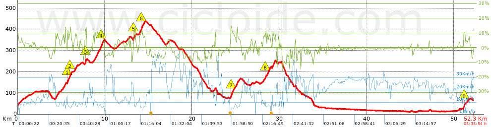
Distance in Km: 52.32
Climb in m: 908
IBP: 69 BYC

Near ...
Cornella De Llobregat, Esplugues De Llobregat, Sant Joan Despi, Sant Just Desvern
alexzm
Author: alexzm
209 published routes

Add to my Group or Club

 Height in m      Climb in %      Speed in Km/h      Speed < 2 Km/h

Climbs > 5%

Climbs >5% Climbs >10% Climbs >15% Climbs >20% Climbs >25%
 Steep slope of 108 m.   Average slope  Distances  Download as waypoint
1
 Km 0  10%  108 m
 Steep slope of 383 m.  Average slope  Distances  Download as waypoint
2
 Km 4.342  9%  106 m
3
 Km 4.447  8%  277 m
 Steep slope of 239 m.  Average slope  Distances  Download as waypoint
4
 Km 5.014  6%  239 m
 Steep slope of 179 m.  Average slope  Distances  Download as waypoint
5
 Km 5.355  9%  179 m
 Steep slope of 582 m.  Average slope  Distances  Download as waypoint
6
 Km 5.663  7%  40 m
7
 Km 5.703  12%  112 m
8
 Km 5.815  8%  169 m
9
 Km 5.984  12%  150 m
10
 Km 6.134  5%  111 m
 Steep slope of 285 m.  Average slope  Distances  Download as waypoint
11
 Km 6.542  9%  285 m
 Steep slope of 103 m.  Average slope  Distances  Download as waypoint
12
 Km 7.146  7%  103 m
 Steep slope of 188 m.  Average slope  Distances  Download as waypoint
13
 Km 7.725  14%  154 m
14
 Km 7.879  9%  34 m
 Steep slope of 1218 m.  Average slope  Distances  Download as waypoint
15
 Km 8.635  8%  895 m
16
 Km 9.53  11%  249 m
17
 Km 9.779  9%  74 m
 Steep slope of 172 m.  Average slope  Distances  Download as waypoint
18
 Km 11.443  6%  172 m
 Steep slope of 142 m.  Average slope  Distances  Download as waypoint
19
 Km 12.611  5%  142 m
 Steep slope of 188 m.  Average slope  Distances  Download as waypoint
20
 Km 13.266  10%  111 m
21
 Km 13.377  12%  77 m
 Steep slope of 730 m.  Average slope  Distances  Download as waypoint
22
 Km 13.889  8%  271 m
23
 Km 14.16  11%  107 m
24
 Km 14.267  7%  352 m
 Steep slope of 241 m.  Average slope  Distances  Download as waypoint
25
 Km 17.153  5%  241 m
 Steep slope of 133 m.  Average slope  Distances  Download as waypoint
26
 Km 22.589  8%  133 m
 Steep slope of 556 m.  Average slope  Distances  Download as waypoint
27
 Km 24.385  8%  36 m
28
 Km 24.421  11%  147 m
29
 Km 24.569  8%  373 m
 Steep slope of 445 m.  Average slope  Distances  Download as waypoint
30
 Km 25.06  8%  445 m
 Steep slope of 304 m.  Average slope  Distances  Download as waypoint
31
 Km 28.137  6%  236 m
32
 Km 28.373  11%  68 m
 Steep slope of 389 m.  Average slope  Distances  Download as waypoint
33
 Km 28.596  10%  389 m
 Steep slope of 388 m.  Average slope  Distances  Download as waypoint
34
 Km 29.172  9%  388 m
 Steep slope of 119 m.  Average slope  Distances  Download as waypoint
35
 Km 29.846  8%  119 m
 Steep slope of 225 m.  Average slope  Distances  Download as waypoint
36
 Km 51.108  9%  42 m
37
 Km 51.15  11%  100 m
38
 Km 51.25  9%  83 m
 Steep slope of 141 m.  Average slope  Distances  Download as waypoint
39
 Km 51.641  5%  141 m


Description of the route


Presence of ramps


 Climbs  Distance  % of the total  Speed  Your speed would be  Time  Your time would be
   15 - 30%  0.119  0.23  4.5  ?  0:01:35  ?
   10 - 15%  2.181  4.17  7.77  ?  0:16:50  ?
   5 - 10%  5.559  10.63  9.15  ?  0:36:27  ?
   1 - 5%  7.948  15.19  12.55  ?  0:38:00  ?
   Total*  15.807 Km  30.21 %  10.21 Km/h  ? Km/h    1:32:52 h  ? h  
 Flat
   1 - -1%  19.716 Km  37.68 %  21.23 Km/h  ? Km/h    0:55:44 h  ? h  
 Descents
   -1 - -5%  8.926  17.06  22.05  ?  0:24:17  ?
   -5 - -10%  6.76  12.92  26.57  ?  0:15:16  ?
   -10 - -15%  0.969  1.85  12.46  ?  0:04:40  ?
   -15 - -30%  0.142  0.27  23.3  ?  0:00:22  ?
   Total*  16.798 Km  32.11 %  22.61 Km/h  ? Km/h    0:44:35 h  ? h  
* The total has not necessarily coincide with the sum of the partials after correction of errors

How long would it take you?

How long would it take you to cover this route?
There are routes without a valid time information, but with your average stats you can assess the possible duration

alexzm to cover this route you've need a time of:   3:13:11 h 
If you sign in and have a minimum of two tracks of this same modality, you can know your time for this route, calculated from your stats..


¿Cuanto consumirá tu E-BIKE?

Entra tu E-IBP (formato n,nn)

E-IBP :   X 69 = 


 Detected activity type =  ()
 Penalization due to track conditions: 61 %   ( > 50 % = MTB, < 50 % = RDB)
 Reliability of the track: B   (907/63/0/-/-/63)
 Correction level applied to the track: 0
DIFFICULTY OF THE ROUTE
IBP = 69 BYC
According to your statistics
 Your time in motion would be: ? h
Your average speed would be: ? Km/h
 

 Total Distance: 52.32 Km
 Analysed distance: 52.32 Km
 Linear distance: 0.51 Km

 Cumulated positive ramps: 907.5 m  list of points info
 Cumulated negative ramps: 865.6 m
 Maximum height: 438.2 m
 Minimum height: 10.2 m
 Climbing Ratio: 5.74 %
 Descent ratio: 5.15 %
 Cumulated postive ramps per Km: 17.35 m
 Cumulated negative ramps per Km: 16.54 m

 Total time: 3:35:54 h
 Time in movement: 3:13:11 h
 According to your statistics
 Your time in motion would be: ? h  
 Stopped time: 0:22:43 h
 Maximum slope filter: ~30 %
 Minimum separation analysed: ~30 m
 Number of points: 2371   (cad. 22.07 m)
 Significant waypoints: 1198   (cad. 43.71 m / 50.53 %)

 Changes in direction per Km: 10.86
 Changes in direction > 5º por Km: 7.53
 Cumulated straight stretches: 9.594 Km
 Straight stretches per Km: 183.37 m
 Penalized slope changes: 8
 Penalized slope changes per Km: 0.153

 Average speed in total: 14.54 Km/h
 Average speed while moving: 16.25 Km/h
 According to your statistics
 Your average speed would be: ? Km/h  
 Maximum sustained speed: 50.68 Km/h


Comments

You can be the first one in commenting this route

 
My comments
:
Add comment  (Registered users)
 
Notify me answers to my comment  Do not notify answers to my comment


Share this route with a friend

Your friend will receive a message with a link to this page:
will see your email and your user name if you do it as registered user.


Write here your name (optional)

E-mail address of your friend(s). You can include various addresses separated by commas

Text or comment (optional) maximum 255 characters long, 255 Available characters

As a non registered users you need to fill-in the captcha text.
  Change image
Type the image characters.
 
 Share with a friend


Visited history

Delete history

Marked routes for review later or compare

My favorites


  Notify anomaly in this route Share in Facebook