Barcelona (Barcelona)

Road
Road
Ref..: 901298
Published: 06/09/2020
Performed: 06/09/2020
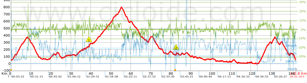
Distance in Km: 142.76
Climb in m: 2224
IBP: 153 BYC

Javi Mora
Author: Javi Mora
257 published routes

Add to my Group or Club

 Height in m      Climb in %      Speed in Km/h      Speed < 2 Km/h

Climbs > 5%

Climbs >5% Climbs >10% Climbs >15% Climbs >20% Climbs >25%
 Steep slope of 469 m.   Average slope  Distances  Download as waypoint
1
 Km 1.656  7%  469 m
 Steep slope of 666 m.  Average slope  Distances  Download as waypoint
2
 Km 2.771  6%  666 m
 Steep slope of 407 m.  Average slope  Distances  Download as waypoint
3
 Km 3.955  7%  407 m
 Steep slope of 182 m.  Average slope  Distances  Download as waypoint
4
 Km 4.509  6%  182 m
 Steep slope of 198 m.  Average slope  Distances  Download as waypoint
5
 Km 5.202  6%  198 m
 Steep slope of 216 m.  Average slope  Distances  Download as waypoint
6
 Km 5.995  5%  216 m
 Steep slope of 110 m.  Average slope  Distances  Download as waypoint
7
 Km 6.738  6%  110 m
 Steep slope of 222 m.  Average slope  Distances  Download as waypoint
8
 Km 7.025  5%  222 m
 Steep slope of 246 m.  Average slope  Distances  Download as waypoint
9
 Km 7.556  6%  246 m
 Steep slope of 186 m.  Average slope  Distances  Download as waypoint
10
 Km 19.619  6%  186 m
 Steep slope of 120 m.  Average slope  Distances  Download as waypoint
11
 Km 21.245  5%  120 m
 Steep slope of 106 m.  Average slope  Distances  Download as waypoint
12
 Km 22.722  8%  106 m
 Steep slope of 187 m.  Average slope  Distances  Download as waypoint
13
 Km 22.953  7%  187 m
 Steep slope of 120 m.  Average slope  Distances  Download as waypoint
14
 Km 32.597  7%  120 m
 Steep slope of 120 m.  Average slope  Distances  Download as waypoint
15
 Km 33.454  10%  120 m
 Steep slope of 105 m.  Average slope  Distances  Download as waypoint
16
 Km 33.839  7%  105 m
 Steep slope of 188 m.  Average slope  Distances  Download as waypoint
17
 Km 34.234  6%  188 m
 Steep slope of 153 m.  Average slope  Distances  Download as waypoint
18
 Km 35.457  6%  153 m
 Steep slope of 168 m.  Average slope  Distances  Download as waypoint
19
 Km 36.214  7%  168 m
 Steep slope of 148 m.  Average slope  Distances  Download as waypoint
20
 Km 37.12  7%  148 m
 Steep slope of 409 m.  Average slope  Distances  Download as waypoint
21
 Km 39.084  11%  157 m
22
 Km 39.241  8%  252 m
 Steep slope of 99 m.  Average slope  Distances  Download as waypoint
23
 Km 39.608  8%  99 m
 Steep slope of 201 m.  Average slope  Distances  Download as waypoint
24
 Km 41.052  7%  201 m
 Steep slope of 327 m.  Average slope  Distances  Download as waypoint
25
 Km 41.784  6%  327 m
 Steep slope of 177 m.  Average slope  Distances  Download as waypoint
26
 Km 42.738  6%  177 m
 Steep slope of 224 m.  Average slope  Distances  Download as waypoint
27
 Km 43.017  5%  224 m
 Steep slope of 210 m.  Average slope  Distances  Download as waypoint
28
 Km 45.793  6%  210 m
 Steep slope of 462 m.  Average slope  Distances  Download as waypoint
29
 Km 47.586  6%  462 m
 Steep slope of 157 m.  Average slope  Distances  Download as waypoint
30
 Km 48.668  6%  157 m
 Steep slope of 163 m.  Average slope  Distances  Download as waypoint
31
 Km 49.414  5%  163 m
 Steep slope of 773 m.  Average slope  Distances  Download as waypoint
32
 Km 50.547  7%  773 m
 Steep slope of 127 m.  Average slope  Distances  Download as waypoint
33
 Km 51.848  6%  127 m
 Steep slope of 195 m.  Average slope  Distances  Download as waypoint
34
 Km 52.469  6%  195 m
 Steep slope of 184 m.  Average slope  Distances  Download as waypoint
35
 Km 53.416  6%  184 m
 Steep slope of 152 m.  Average slope  Distances  Download as waypoint
36
 Km 54.067  6%  152 m
 Steep slope of 473 m.  Average slope  Distances  Download as waypoint
37
 Km 54.355  7%  473 m
 Steep slope of 324 m.  Average slope  Distances  Download as waypoint
38
 Km 54.946  6%  324 m
 Steep slope of 577 m.  Average slope  Distances  Download as waypoint
39
 Km 68.82  7%  577 m
 Steep slope of 151 m.  Average slope  Distances  Download as waypoint
40
 Km 69.572  8%  151 m
 Steep slope of 155 m.  Average slope  Distances  Download as waypoint
41
 Km 78.85  7%  155 m
 Steep slope of 263 m.  Average slope  Distances  Download as waypoint
42
 Km 79.387  6%  263 m
 Steep slope of 291 m.  Average slope  Distances  Download as waypoint
43
 Km 82.666  11%  152 m
44
 Km 82.819  8%  139 m
 Steep slope of 146 m.  Average slope  Distances  Download as waypoint
45
 Km 85.125  5%  146 m
 Steep slope of 133 m.  Average slope  Distances  Download as waypoint
46
 Km 91.843  6%  133 m
 Steep slope of 154 m.  Average slope  Distances  Download as waypoint
47
 Km 109.251  7%  154 m
 Steep slope of 129 m.  Average slope  Distances  Download as waypoint
48
 Km 110.212  6%  129 m
 Steep slope of 110 m.  Average slope  Distances  Download as waypoint
49
 Km 118.268  8%  110 m
 Steep slope of 204 m.  Average slope  Distances  Download as waypoint
50
 Km 124.142  6%  204 m
 Steep slope of 131 m.  Average slope  Distances  Download as waypoint
51
 Km 124.618  6%  131 m
 Steep slope of 165 m.  Average slope  Distances  Download as waypoint
52
 Km 124.886  5%  165 m
 Steep slope of 2177 m.  Average slope  Distances  Download as waypoint
53
 Km 125.272  6%  2177 m
 Steep slope of 335 m.  Average slope  Distances  Download as waypoint
54
 Km 127.566  6%  335 m
 Steep slope of 279 m.  Average slope  Distances  Download as waypoint
55
 Km 128.076  6%  279 m
 Steep slope of 214 m.  Average slope  Distances  Download as waypoint
56
 Km 128.96  6%  214 m
 Steep slope of 117 m.  Average slope  Distances  Download as waypoint
57
 Km 129.288  5%  117 m
 Steep slope of 588 m.  Average slope  Distances  Download as waypoint
58
 Km 130.507  7%  588 m
 Steep slope of 287 m.  Average slope  Distances  Download as waypoint
59
 Km 131.79  6%  287 m
 Steep slope of 238 m.  Average slope  Distances  Download as waypoint
60
 Km 134.711  6%  238 m
 Steep slope of 124 m.  Average slope  Distances  Download as waypoint
61
 Km 135.099  5%  124 m
 Steep slope of 259 m.  Average slope  Distances  Download as waypoint
62
 Km 139.694  7%  259 m


Description of the route


Presence of ramps


 Climbs  Distance  % of the total  Speed  Your speed would be  Time  Your time would be
   15 - 30%  0.056  0.04  33.87  ?  0:00:06  ?
   10 - 15%  0.882  0.62  15.96  ?  0:03:19  ?
   5 - 10%  18.104  12.68  16.04  ?  1:07:43  ?
   1 - 5%  32.883  23.03  21.83  ?  1:30:23  ?
   Total*  51.926 Km  36.37 %  19.29 Km/h  ? Km/h    2:41:31 h  ? h  
 Flat
   1 - -1%  38.227 Km  26.78 %  31.01 Km/h  ? Km/h    1:13:58 h  ? h  
 Descents
   -1 - -5%  34.509  24.17  36.88  ?  0:56:09  ?
   -5 - -10%  17.047  11.94  41.66  ?  0:24:33  ?
   -10 - -15%  0.949  0.66  33.16  ?  0:01:43  ?
   -15 - -30%  0.115  0.08  37.65  ?  0:00:11  ?
   Total*  52.62 Km  36.86 %  38.22 Km/h  ? Km/h    1:22:36 h  ? h  
* The total has not necessarily coincide with the sum of the partials after correction of errors

How long would it take you?

How long would it take you to cover this route?
There are routes without a valid time information, but with your average stats you can assess the possible duration

Javi Mora to cover this route you've need a time of:   5:18:05 h 
If you sign in and have a minimum of two tracks of this same modality, you can know your time for this route, calculated from your stats..


¿Cuanto consumirá tu E-BIKE?

Entra tu E-IBP (formato n,nn)

E-IBP :   X 153 = 


 Detected activity type =  ()
 Penalization due to track conditions: 38 %   ( > 50 % = MTB, < 50 % = RDB)
 Reliability of the track: A   (2237/76/0/-/-/76)
 Correction level applied to the track: 0
DIFFICULTY OF THE ROUTE
IBP = 153 BYC
According to your statistics
 Your time in motion would be: ? h
Your average speed would be: ? Km/h
 

 Total Distance: 142.76 Km
 Analysed distance: 142.76 Km
 Linear distance: 0.09 Km

 Cumulated positive ramps: 2223.72 m  list of points info
 Cumulated negative ramps: 2184.12 m
 Maximum height: 799.8 m
 Minimum height: -2.4 m
 Climbing Ratio: 4.28 %
 Descent ratio: 4.15 %
 Cumulated postive ramps per Km: 15.58 m
 Cumulated negative ramps per Km: 15.3 m

 Total time: 5:51:18 h
 Time in movement: 5:18:05 h
 According to your statistics
 Your time in motion would be: ? h  
 Stopped time: 0:33:13 h
 Maximum slope filter: ~30 %
 Minimum separation analysed: ~30 m
 Number of points: 5043   (cad. 28.31 m)
 Significant waypoints: 3050   (cad. 46.82 m / 60.48 %)

 Changes in direction per Km: 6.89
 Changes in direction > 5º por Km: 4.64
 Cumulated straight stretches: 44.041 Km
 Straight stretches per Km: 308.5 m
 Penalized slope changes: 15
 Penalized slope changes per Km: 0.105

 Average speed in total: 24.38 Km/h
 Average speed while moving: 26.93 Km/h
 According to your statistics
 Your average speed would be: ? Km/h  
 Maximum sustained speed: 59.17 Km/h


Comments

You can be the first one in commenting this route

 
My comments
:
Add comment  (Registered users)
 
Notify me answers to my comment  Do not notify answers to my comment


Share this route with a friend

Your friend will receive a message with a link to this page:
will see your email and your user name if you do it as registered user.


Write here your name (optional)

E-mail address of your friend(s). You can include various addresses separated by commas

Text or comment (optional) maximum 255 characters long, 255 Available characters

As a non registered users you need to fill-in the captcha text.
  Change image
Type the image characters.
 
 Share with a friend


Visited history

Delete history

Marked routes for review later or compare

My favorites


  Notify anomaly in this route Share in Facebook