Valls (Tarragona)

MTB
MTB
Ref..: 899460
Published: 31/08/2020
Performed: 30/08/2020
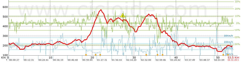
Distance in Km: 53.5
Climb in m: 1103
IBP: 85 BYC

Eduard_Alcaine
220 published routes

Add to my Group or Club

 Height in m      Climb in %      Speed in Km/h      Speed < 2 Km/h

Climbs > 5%

Climbs >5% Climbs >10% Climbs >15% Climbs >20% Climbs >25%
 Steep slope of 137 m.   Average slope  Distances  Download as waypoint
1
 Km 0  7%  137 m
 Steep slope of 97 m.  Average slope  Distances  Download as waypoint
2
 Km 0.604  6%  97 m
 Steep slope of 282 m.  Average slope  Distances  Download as waypoint
3
 Km 3.768  8%  71 m
4
 Km 3.839  13%  138 m
5
 Km 3.977  8%  73 m
 Steep slope of 139 m.  Average slope  Distances  Download as waypoint
6
 Km 15.706  7%  139 m
 Steep slope of 143 m.  Average slope  Distances  Download as waypoint
7
 Km 17.484  7%  143 m
 Steep slope of 382 m.  Average slope  Distances  Download as waypoint
8
 Km 18.663  8%  382 m
 Steep slope of 173 m.  Average slope  Distances  Download as waypoint
9
 Km 19.185  6%  173 m
 Steep slope of 2124 m.  Average slope  Distances  Download as waypoint
10
 Km 19.469  9%  103 m
11
 Km 19.572  12%  139 m
12
 Km 19.711  9%  231 m
13
 Km 19.942  12%  464 m
14
 Km 20.406  14%  107 m
15
 Km 20.513  13%  179 m
16
 Km 20.691  8%  136 m
17
 Km 20.828  12%  241 m
18
 Km 21.069  8%  212 m
19
 Km 21.281  10%  239 m
20
 Km 21.519  13%  73 m
 Steep slope of 473 m.  Average slope  Distances  Download as waypoint
21
 Km 23.55  8%  473 m
 Steep slope of 219 m.  Average slope  Distances  Download as waypoint
22
 Km 24.943  6%  38 m
23
 Km 24.981  13%  140 m
24
 Km 25.121  6%  41 m
 Steep slope of 112 m.  Average slope  Distances  Download as waypoint
25
 Km 25.352  10%  112 m
 Steep slope of 145 m.  Average slope  Distances  Download as waypoint
26
 Km 27.277  16%  107 m
27
 Km 27.384  5%  38 m
 Steep slope of 108 m.  Average slope  Distances  Download as waypoint
28
 Km 27.932  14%  108 m
 Steep slope of 453 m.  Average slope  Distances  Download as waypoint
29
 Km 30.503  6%  67 m
30
 Km 30.571  12%  288 m
31
 Km 30.858  12%  98 m
 Steep slope of 358 m.  Average slope  Distances  Download as waypoint
32
 Km 31.524  10%  29 m
33
 Km 31.553  13%  110 m
34
 Km 31.663  6%  219 m
 Steep slope of 719 m.  Average slope  Distances  Download as waypoint
35
 Km 31.989  8%  719 m
 Steep slope of 208 m.  Average slope  Distances  Download as waypoint
36
 Km 33.165  7%  208 m
 Steep slope of 114 m.  Average slope  Distances  Download as waypoint
37
 Km 33.902  5%  114 m
 Steep slope of 108 m.  Average slope  Distances  Download as waypoint
38
 Km 51.102  10%  108 m
 Steep slope of 105 m.  Average slope  Distances  Download as waypoint
39
 Km 51.429  8%  105 m
 Steep slope of 155 m.  Average slope  Distances  Download as waypoint
40
 Km 52.025  7%  155 m
 Steep slope of 106 m.  Average slope  Distances  Download as waypoint
41
 Km 53.27  7%  106 m


Description of the route


Presence of ramps


 Climbs  Distance  % of the total  Speed  Your speed would be  Time  Your time would be
   15 - 30%  0.477  0.89  6.76  ?  0:04:14  ?
   10 - 15%  2.367  4.42  8.03  ?  0:17:41  ?
   5 - 10%  6.217  11.62  9.86  ?  0:37:50  ?
   1 - 5%  11.3  21.12  13.24  ?  0:51:13  ?
   Total*  20.361 Km  38.06 %  11.01 Km/h  ? Km/h    1:50:58 h  ? h  
 Flat
   1 - -1%  12.599 Km  23.55 %  16.77 Km/h  ? Km/h    0:45:04 h  ? h  
 Descents
   -1 - -5%  13.028  24.35  21.57  ?  0:36:14  ?
   -5 - -10%  4.484  8.38  24.31  ?  0:11:04  ?
   -10 - -15%  2.013  3.76  22.16  ?  0:05:27  ?
   -15 - -30%  1.016  1.9  12.7  ?  0:04:48  ?
   Total*  20.541 Km  38.39 %  21.41 Km/h  ? Km/h    0:57:33 h  ? h  
* The total has not necessarily coincide with the sum of the partials after correction of errors

How long would it take you?

How long would it take you to cover this route?
There are routes without a valid time information, but with your average stats you can assess the possible duration

Eduard_Alcaine to cover this route you've need a time of:   3:33:35 h 
If you sign in and have a minimum of two tracks of this same modality, you can know your time for this route, calculated from your stats..


¿Cuanto consumirá tu E-BIKE?

Entra tu E-IBP (formato n,nn)

E-IBP :   X 85 = 


 Detected activity type =  ()
 Penalization due to track conditions: 67 %   ( > 50 % = MTB, < 50 % = RDB)
 Reliability of the track: B   (1105/64/0/-/-/64)
 Correction level applied to the track: 0
DIFFICULTY OF THE ROUTE
IBP = 85 BYC
According to your statistics
 Your time in motion would be: ? h
Your average speed would be: ? Km/h
 

 Total Distance: 53.5 Km
 Analysed distance: 53.5 Km
 Linear distance: 0.09 Km

 Cumulated positive ramps: 1103.38 m  list of points info
 Cumulated negative ramps: 1115.58 m
 Maximum height: 572.2 m
 Minimum height: 138.6 m
 Climbing Ratio: 5.42 %
 Descent ratio: 5.43 %
 Cumulated postive ramps per Km: 20.62 m
 Cumulated negative ramps per Km: 20.85 m

 Total time: 4:31:25 h
 Time in movement: 3:33:35 h
 According to your statistics
 Your time in motion would be: ? h  
 Stopped time: 0:57:50 h
 Maximum slope filter: ~30 %
 Minimum separation analysed: ~30 m
 Number of points: 4024   (cad. 13.3 m)
 Significant waypoints: 1498   (cad. 35.71 m / 37.23 %)

 Changes in direction per Km: 11.36
 Changes in direction > 5º por Km: 7.48
 Cumulated straight stretches: 14.717 Km
 Straight stretches per Km: 275.08 m
 Penalized slope changes: 9
 Penalized slope changes per Km: 0.168

 Average speed in total: 11.83 Km/h
 Average speed while moving: 15.03 Km/h
 According to your statistics
 Your average speed would be: ? Km/h  
 Maximum sustained speed: 54.75 Km/h


Comments

You can be the first one in commenting this route

 
My comments
:
Add comment  (Registered users)
 
Notify me answers to my comment  Do not notify answers to my comment


Share this route with a friend

Your friend will receive a message with a link to this page:
will see your email and your user name if you do it as registered user.


Write here your name (optional)

E-mail address of your friend(s). You can include various addresses separated by commas

Text or comment (optional) maximum 255 characters long, 255 Available characters

As a non registered users you need to fill-in the captcha text.
  Change image
Type the image characters.
 
 Share with a friend


Visited history

Delete history

Marked routes for review later or compare

My favorites


  Notify anomaly in this route Share in Facebook