Sierra Nevada 20. Vereas, senderos y corriols por el Marquesado
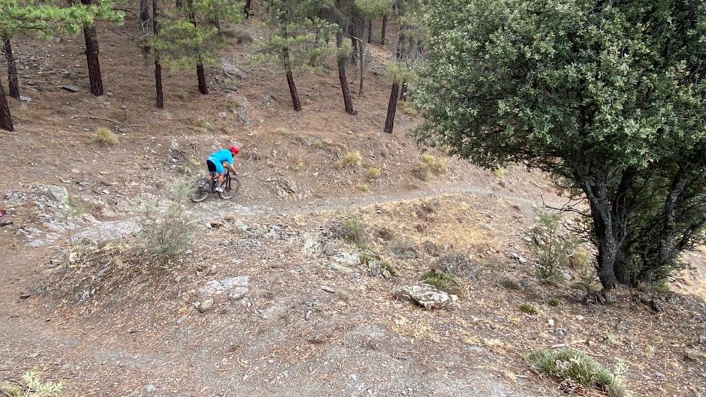
MTB
MTB
Ref..: 893988
Published: 12/08/2020
Performed: 11/08/2020
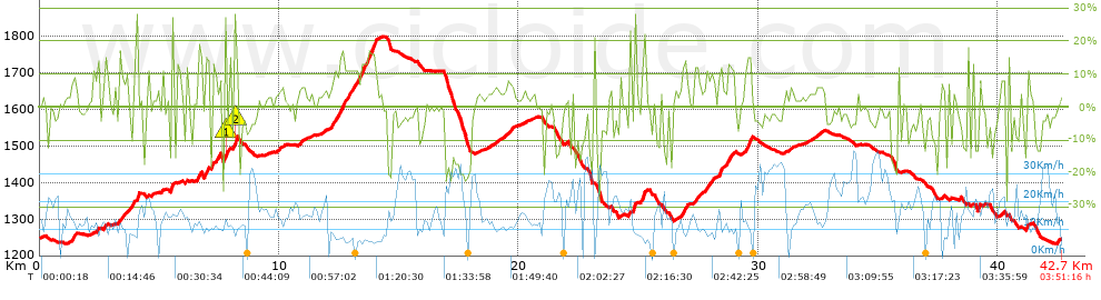
Distance in Km: 42.66
Climb in m: 1463
IBP: 134 BYC

silvesterbike
396 published routes

Add to my Group or Club

 Height in m      Climb in %      Speed in Km/h      Speed < 2 Km/h

Climbs > 5%

Climbs >5% Climbs >10% Climbs >15% Climbs >20% Climbs >25%
 Steep slope of 264 m.   Average slope  Distances  Download as waypoint
1
 Km 1.315  9%  264 m
 Steep slope of 147 m.  Average slope  Distances  Download as waypoint
2
 Km 2.698  6%  117 m
3
 Km 2.815  12%  30 m
 Steep slope of 465 m.  Average slope  Distances  Download as waypoint
4
 Km 3.292  9%  465 m
 Steep slope of 198 m.  Average slope  Distances  Download as waypoint
5
 Km 3.908  10%  151 m
6
 Km 4.059  28%  47 m
 Steep slope of 126 m.  Average slope  Distances  Download as waypoint
7
 Km 5.105  8%  126 m
 Steep slope of 121 m.  Average slope  Distances  Download as waypoint
8
 Km 5.496  23%  121 m
 Steep slope of 188 m.  Average slope  Distances  Download as waypoint
9
 Km 6.564  5%  33 m
10
 Km 6.596  13%  114 m
11
 Km 6.711  15%  41 m
 Steep slope of 216 m.  Average slope  Distances  Download as waypoint
12
 Km 6.871  16%  182 m
13
 Km 7.053  21%  34 m
 Steep slope of 309 m.  Average slope  Distances  Download as waypoint
14
 Km 7.205  10%  117 m
15
 Km 7.322  10%  46 m
16
 Km 7.368  14%  146 m
 Steep slope of 108 m.  Average slope  Distances  Download as waypoint
17
 Km 7.714  27%  108 m
 Steep slope of 175 m.  Average slope  Distances  Download as waypoint
18
 Km 8.096  9%  40 m
19
 Km 8.136  28%  103 m
20
 Km 8.24  9%  32 m
 Steep slope of 169 m.  Average slope  Distances  Download as waypoint
21
 Km 9.958  5%  169 m
 Steep slope of 271 m.  Average slope  Distances  Download as waypoint
22
 Km 10.783  6%  271 m
 Steep slope of 2032 m.  Average slope  Distances  Download as waypoint
23
 Km 12.057  7%  273 m
24
 Km 12.33  12%  257 m
25
 Km 12.587  16%  117 m
26
 Km 12.703  11%  548 m
27
 Km 13.251  10%  120 m
28
 Km 13.371  14%  314 m
29
 Km 13.685  16%  286 m
30
 Km 13.971  16%  77 m
31
 Km 14.048  9%  40 m
 Steep slope of 192 m.  Average slope  Distances  Download as waypoint
32
 Km 18.94  5%  192 m
 Steep slope of 381 m.  Average slope  Distances  Download as waypoint
33
 Km 19.396  7%  381 m
 Steep slope of 228 m.  Average slope  Distances  Download as waypoint
34
 Km 24.598  11%  228 m
 Steep slope of 205 m.  Average slope  Distances  Download as waypoint
35
 Km 25.093  7%  30 m
36
 Km 25.123  16%  175 m
 Steep slope of 327 m.  Average slope  Distances  Download as waypoint
37
 Km 26.749  5%  33 m
38
 Km 26.782  12%  224 m
39
 Km 27.007  7%  70 m
 Steep slope of 342 m.  Average slope  Distances  Download as waypoint
40
 Km 27.346  12%  127 m
41
 Km 27.473  6%  215 m
 Steep slope of 362 m.  Average slope  Distances  Download as waypoint
42
 Km 27.802  11%  99 m
43
 Km 27.901  9%  263 m
 Steep slope of 598 m.  Average slope  Distances  Download as waypoint
44
 Km 28.321  9%  36 m
45
 Km 28.357  13%  168 m
46
 Km 28.526  6%  176 m
47
 Km 28.702  12%  178 m
48
 Km 28.88  9%  40 m
 Steep slope of 330 m.  Average slope  Distances  Download as waypoint
49
 Km 29.399  8%  72 m
50
 Km 29.471  15%  258 m
 Steep slope of 110 m.  Average slope  Distances  Download as waypoint
51
 Km 31.297  5%  110 m
 Steep slope of 112 m.  Average slope  Distances  Download as waypoint
52
 Km 32.391  5%  112 m
 Steep slope of 211 m.  Average slope  Distances  Download as waypoint
53
 Km 39.176  7%  211 m
 Steep slope of 150 m.  Average slope  Distances  Download as waypoint
54
 Km 40.142  8%  150 m
 Steep slope of 147 m.  Average slope  Distances  Download as waypoint
55
 Km 41.165  7%  30 m
56
 Km 41.195  8%  117 m


Description of the route


Presence of ramps


 Climbs  Distance  % of the total  Speed  Your speed would be  Time  Your time would be
   15 - 30%  2.058  4.82  10.16  ?  0:12:09  ?
   10 - 15%  3.429  8.04  9.64  ?  0:21:21  ?
   5 - 10%  4.793  11.24  11.37  ?  0:25:17  ?
   1 - 5%  9.444  22.14  13.65  ?  0:41:30  ?
   Total*  19.723 Km  46.24 %  11.8 Km/h  ? Km/h    1:40:17 h  ? h  
 Flat
   1 - -1%  4.605 Km  10.79 %  15.06 Km/h  ? Km/h    0:18:21 h  ? h  
 Descents
   -1 - -5%  8.496  19.92  19.51  ?  0:26:08  ?
   -5 - -10%  4.046  9.49  16.57  ?  0:14:39  ?
   -10 - -15%  2.839  6.66  15.19  ?  0:11:13  ?
   -15 - -30%  2.949  6.91  18.56  ?  0:09:32  ?
   Total*  18.33 Km  42.97 %  17.87 Km/h  ? Km/h    1:01:32 h  ? h  
* The total has not necessarily coincide with the sum of the partials after correction of errors

How long would it take you?

How long would it take you to cover this route?
There are routes without a valid time information, but with your average stats you can assess the possible duration

silvesterbike to cover this route you've need a time of:   3:00:10 h 
If you sign in and have a minimum of two tracks of this same modality, you can know your time for this route, calculated from your stats..


¿Cuanto consumirá tu E-BIKE?

Entra tu E-IBP (formato n,nn)

E-IBP :   X 134 = 


 Detected activity type =  ()
 Penalization due to track conditions: 85 %   ( > 50 % = MTB, < 50 % = RDB)
 Reliability of the track: C   (1465/54/0/-/-/54)
 Correction level applied to the track: 0
DIFFICULTY OF THE ROUTE
IBP = 134 BYC
According to your statistics
 Your time in motion would be: ? h
Your average speed would be: ? Km/h
 

 Total Distance: 42.66 Km
 Analysed distance: 42.66 Km
 Linear distance: 0.43 Km

 Cumulated positive ramps: 1462.99 m  list of points info
 Cumulated negative ramps: 1468.19 m
 Maximum height: 1797.9 m
 Minimum height: 1232.2 m
 Climbing Ratio: 7.42 %
 Descent ratio: 8.01 %
 Cumulated postive ramps per Km: 34.29 m
 Cumulated negative ramps per Km: 34.42 m

 Total time: 3:51:16 h
 Time in movement: 3:00:10 h
 According to your statistics
 Your time in motion would be: ? h  
 Stopped time: 0:51:06 h
 Maximum slope filter: ~30 %
 Minimum separation analysed: ~30 m
 Number of points: 2284   (cad. 18.68 m)
 Significant waypoints: 1079   (cad. 39.54 m / 47.24 %)

 Changes in direction per Km: 10.81
 Changes in direction > 5º por Km: 8.27
 Cumulated straight stretches: 6.506 Km
 Straight stretches per Km: 152.51 m
 Penalized slope changes: 12
 Penalized slope changes per Km: 0.281

 Average speed in total: 11.07 Km/h
 Average speed while moving: 14.21 Km/h
 According to your statistics
 Your average speed would be: ? Km/h  
 Maximum sustained speed: 40.05 Km/h


Comments

You can be the first one in commenting this route

 
My comments
:
Add comment  (Registered users)
 
Notify me answers to my comment  Do not notify answers to my comment


Share this route with a friend

Your friend will receive a message with a link to this page:
will see your email and your user name if you do it as registered user.


Write here your name (optional)

E-mail address of your friend(s). You can include various addresses separated by commas

Text or comment (optional) maximum 255 characters long, 255 Available characters

As a non registered users you need to fill-in the captcha text.
  Change image
Type the image characters.
 
 Share with a friend


Visited history

Delete history

Marked routes for review later or compare

My favorites


  Notify anomaly in this route Share in Facebook