Corbalan - Vértice Cabigordo

Running
Running
Ref..: 893708
Published: 10/08/2020
Performed: 10/08/2020
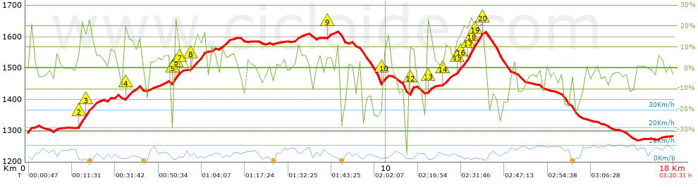
Distance in Km: 17.96
Climb in m: 752
IBP: 167 RNG


 Height in m      Climb in %      Speed in Km/h      Speed < 2 Km/h

Climbs > 10%

Climbs >5% Climbs >10% Climbs >15% Climbs >20% Climbs >25%
 Steep slope of 425 m.   Average slope  Distances  Download as waypoint
1
 Km 1.458  15%  31 m
2
 Km 1.489  19%  202 m
3
 Km 1.69  14%  192 m
 Steep slope of 242 m.  Average slope  Distances  Download as waypoint
4
 Km 2.74  13%  242 m
 Steep slope of 165 m.  Average slope  Distances  Download as waypoint
5
 Km 4.09  26%  100 m
6
 Km 4.19  18%  32 m
7
 Km 4.221  10%  33 m
 Steep slope of 445 m.  Average slope  Distances  Download as waypoint
8
 Km 4.563  13%  445 m
 Steep slope of 106 m.  Average slope  Distances  Download as waypoint
9
 Km 8.366  10%  106 m
 Steep slope of 127 m.  Average slope  Distances  Download as waypoint
10
 Km 9.874  13%  127 m
 Steep slope of 125 m.  Average slope  Distances  Download as waypoint
11
 Km 10.622  10%  31 m
12
 Km 10.654  21%  94 m
 Steep slope of 130 m.  Average slope  Distances  Download as waypoint
13
 Km 11.132  16%  130 m
 Steep slope of 249 m.  Average slope  Distances  Download as waypoint
14
 Km 11.59  12%  249 m
 Steep slope of 737 m.  Average slope  Distances  Download as waypoint
15
 Km 11.944  14%  103 m
16
 Km 12.047  15%  233 m
17
 Km 12.28  23%  132 m
18
 Km 12.412  18%  102 m
19
 Km 12.514  19%  167 m
20
 Km 12.682  22%  34 m


Description of the route


Presence of ramps


 Climbs  Distance  % of the total  Speed  Your speed would be  Time  Your time would be
   15 - 30%  1.422  7.91  3.86  ?  0:22:07  ?
   10 - 15%  1.886  10.49  4.44  ?  0:25:29  ?
   5 - 10%  2.198  12.23  5.54  ?  0:23:47  ?
   1 - 5%  2.874  15.99  7.22  ?  0:23:52  ?
   Total*  8.411 Km  46.8 %  5.26 Km/h  ? Km/h    1:36:00 h  ? h  
 Flat
   1 - -1%  1.589 Km  8.84 %  6.99 Km/h  ? Km/h    0:13:39 h  ? h  
 Descents
   -1 - -5%  3.037  16.9  8.07  ?  0:22:34  ?
   -5 - -10%  2.008  11.17  7.07  ?  0:17:03  ?
   -10 - -15%  1.122  6.24  6.85  ?  0:09:49  ?
   -15 - -30%  1.619  9.01  5.26  ?  0:18:29  ?
   Total*  7.972 Km  44.36 %  6.59 Km/h  ? Km/h    1:12:38 h  ? h  
* The total has not necessarily coincide with the sum of the partials after correction of errors

How long would it take you?

How long would it take you to cover this route?
There are routes without a valid time information, but with your average stats you can assess the possible duration

Roberto Rodrigo Perez to cover this route you've need a time of:   3:02:17 h 
If you sign in and have a minimum of two tracks of this same modality, you can know your time for this route, calculated from your stats..


 Detected activity type =  ()
 Penalization due to track conditions: 0 %   ( > 50 % = MTB, < 50 % = RDB)
 Reliability of the track: C   (752/57/0/-/-/57)
 Correction level applied to the track: 0
DIFFICULTY OF THE ROUTE
IBP = 167 RNG
According to your statistics
 Your time in motion would be: ? h
Your average speed would be: ? Km/h
 

 Total Distance: 17.97 Km
 Analysed distance: 17.97 Km
 Linear distance: 0.05 Km

 Cumulated positive ramps: 752.4 m  list of points info
 Cumulated negative ramps: 765.6 m
 Maximum height: 1616.4 m
 Minimum height: 1268.6 m
 Climbing Ratio: 8.95 %
 Descent ratio: 9.6 %
 Cumulated postive ramps per Km: 41.87 m
 Cumulated negative ramps per Km: 42.6 m

 Total time: 3:20:31 h
 Time in movement: 3:02:17 h
 According to your statistics
 Your time in motion would be: ? h  
 Stopped time: 0:18:14 h
 Maximum slope filter: ~55 %
 Minimum separation analysed: ~30 m
 Number of points: 1566   (cad. 11.48 m)
 Significant waypoints: 527   (cad. 34.1 m / 33.65 %)

 Changes in direction per Km: 13.91
 Changes in direction > 5º por Km: 9.91
 Cumulated straight stretches: 2.394 Km
 Straight stretches per Km: 133.22 m
 Penalized slope changes: 6
 Penalized slope changes per Km: 0.334

 Average speed in total: 5.38 Km/h
 Average speed while moving: 5.91 Km/h
 According to your statistics
 Your average speed would be: ? Km/h  
 Maximum sustained speed: 12.5 Km/h


Comments

You can be the first one in commenting this route

 
My comments
:
Add comment  (Registered users)
 
Notify me answers to my comment  Do not notify answers to my comment


Share this route with a friend

Your friend will receive a message with a link to this page:
will see your email and your user name if you do it as registered user.


Write here your name (optional)

E-mail address of your friend(s). You can include various addresses separated by commas

Text or comment (optional) maximum 255 characters long, 255 Available characters

As a non registered users you need to fill-in the captcha text.
  Change image
Type the image characters.
 
 Share with a friend


Visited history

Delete history

Marked routes for review later or compare

My favorites


  Notify anomaly in this route Share in Facebook