Punta Dell'Orto

MTB
MTB
Ref..: 873161
Published: 30/05/2020
Performed: 29/05/2020
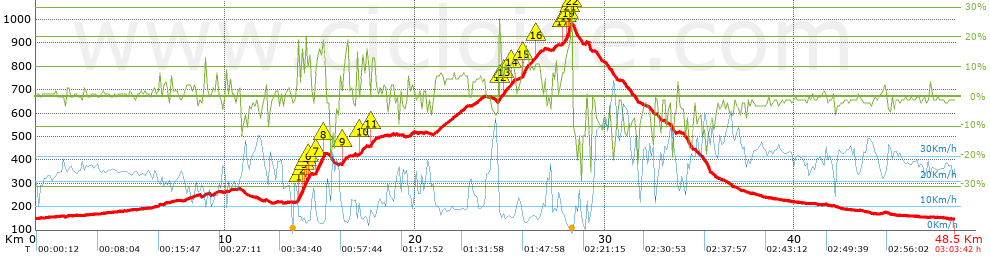
Distance in Km: 48.47
Climb in m: 1096
IBP: 97 BYC

Beppe Cavalli
568 published routes

Add to my Group or Club

 Height in m      Climb in %      Speed in Km/h      Speed < 2 Km/h

Climbs > 5%

Climbs >5% Climbs >10% Climbs >15% Climbs >20% Climbs >25%
 Steep slope of 106 m.   Average slope  Distances  Download as waypoint
1
 Km 6.478  6%  106 m
 Steep slope of 99 m.  Average slope  Distances  Download as waypoint
2
 Km 6.758  5%  99 m
 Steep slope of 107 m.  Average slope  Distances  Download as waypoint
3
 Km 9.369  6%  107 m
 Steep slope of 750 m.  Average slope  Distances  Download as waypoint
4
 Km 13.791  8%  33 m
5
 Km 13.824  17%  262 m
6
 Km 14.086  16%  97 m
7
 Km 14.183  19%  98 m
8
 Km 14.281  16%  96 m
9
 Km 14.376  18%  33 m
10
 Km 14.409  16%  65 m
11
 Km 14.474  8%  66 m
 Steep slope of 524 m.  Average slope  Distances  Download as waypoint
12
 Km 14.729  7%  35 m
13
 Km 14.764  18%  390 m
14
 Km 15.153  16%  99 m
 Steep slope of 161 m.  Average slope  Distances  Download as waypoint
15
 Km 16.179  13%  129 m
16
 Km 16.308  5%  32 m
 Steep slope of 265 m.  Average slope  Distances  Download as waypoint
17
 Km 16.944  6%  169 m
18
 Km 17.113  10%  96 m
 Steep slope of 126 m.  Average slope  Distances  Download as waypoint
19
 Km 17.309  8%  126 m
 Steep slope of 229 m.  Average slope  Distances  Download as waypoint
20
 Km 17.669  12%  195 m
21
 Km 17.864  18%  34 m
 Steep slope of 455 m.  Average slope  Distances  Download as waypoint
22
 Km 21.01  8%  455 m
 Steep slope of 1156 m.  Average slope  Distances  Download as waypoint
23
 Km 21.569  7%  1156 m
 Steep slope of 567 m.  Average slope  Distances  Download as waypoint
24
 Km 23.049  6%  567 m
 Steep slope of 884 m.  Average slope  Distances  Download as waypoint
25
 Km 24.389  9%  33 m
26
 Km 24.422  16%  163 m
27
 Km 24.584  7%  98 m
28
 Km 24.682  12%  129 m
29
 Km 24.811  9%  232 m
30
 Km 25.044  11%  198 m
31
 Km 25.242  8%  31 m
 Steep slope of 1085 m.  Average slope  Distances  Download as waypoint
32
 Km 25.582  7%  36 m
33
 Km 25.618  13%  392 m
34
 Km 26.01  9%  328 m
35
 Km 26.338  11%  225 m
36
 Km 26.563  8%  104 m
 Steep slope of 106 m.  Average slope  Distances  Download as waypoint
37
 Km 26.771  8%  106 m
 Steep slope of 197 m.  Average slope  Distances  Download as waypoint
38
 Km 27.229  8%  197 m
 Steep slope of 530 m.  Average slope  Distances  Download as waypoint
39
 Km 27.74  8%  32 m
40
 Km 27.772  11%  189 m
41
 Km 27.961  16%  92 m
42
 Km 28.053  22%  123 m
43
 Km 28.175  25%  31 m
44
 Km 28.207  28%  32 m
45
 Km 28.239  28%  31 m


Description of the route


Presence of ramps


 Climbs  Distance  % of the total  Speed  Your speed would be  Time  Your time would be
   15 - 30%  1.706  3.52  4.84  ?  0:21:08  ?
   10 - 15%  1.906  3.93  6.44  ?  0:17:46  ?
   5 - 10%  4.819  9.94  9.85  ?  0:29:21  ?
   1 - 5%  7.954  16.41  17.04  ?  0:28:00  ?
   Total*  16.385 Km  33.8 %  10.21 Km/h  ? Km/h    1:36:15 h  ? h  
 Flat
   1 - -1%  12.867 Km  26.54 %  24.55 Km/h  ? Km/h    0:31:27 h  ? h  
 Descents
   -1 - -5%  11.55  23.83  27.92  ?  0:24:49  ?
   -5 - -10%  3.978  8.21  27.6  ?  0:08:39  ?
   -10 - -15%  2.541  5.24  18.41  ?  0:08:17  ?
   -15 - -30%  1.151  2.37  15.4  ?  0:04:29  ?
   Total*  19.22 Km  39.65 %  24.94 Km/h  ? Km/h    0:46:14 h  ? h  
* The total has not necessarily coincide with the sum of the partials after correction of errors

How long would it take you?

How long would it take you to cover this route?
There are routes without a valid time information, but with your average stats you can assess the possible duration

Beppe Cavalli to cover this route you've need a time of:   2:53:56 h 
If you sign in and have a minimum of two tracks of this same modality, you can know your time for this route, calculated from your stats..


¿Cuanto consumirá tu E-BIKE?

Entra tu E-IBP (formato n,nn)

E-IBP :   X 97 = 


 Detected activity type =  ()
 Penalization due to track conditions: 61 %   ( > 50 % = MTB, < 50 % = RDB)
 Reliability of the track: A   (1100/74/0/-/-/74)
 Correction level applied to the track: 0
DIFFICULTY OF THE ROUTE
IBP = 97 BYC
According to your statistics
 Your time in motion would be: ? h
Your average speed would be: ? Km/h
 

 Total Distance: 48.47 Km
 Analysed distance: 48.47 Km
 Linear distance: 0.43 Km

 Cumulated positive ramps: 1096.01 m  list of points info
 Cumulated negative ramps: 1103.01 m
 Maximum height: 982.33 m
 Minimum height: 146.8 m
 Climbing Ratio: 6.69 %
 Descent ratio: 5.74 %
 Cumulated postive ramps per Km: 22.61 m
 Cumulated negative ramps per Km: 22.76 m

 Total time: 3:03:42 h
 Time in movement: 2:53:56 h
 According to your statistics
 Your time in motion would be: ? h  
 Stopped time: 0:09:46 h
 Maximum slope filter: ~30 %
 Minimum separation analysed: ~30 m
 Number of points: 3615   (cad. 13.41 m)
 Significant waypoints: 1362   (cad. 35.59 m / 37.68 %)

 Changes in direction per Km: 10.15
 Changes in direction > 5º por Km: 6.33
 Cumulated straight stretches: 12.139 Km
 Straight stretches per Km: 250.44 m
 Penalized slope changes: 7
 Penalized slope changes per Km: 0.144

 Average speed in total: 15.83 Km/h
 Average speed while moving: 16.72 Km/h
 According to your statistics
 Your average speed would be: ? Km/h  
 Maximum sustained speed: 59.86 Km/h


Comments

You can be the first one in commenting this route

 
My comments
:
Add comment  (Registered users)
 
Notify me answers to my comment  Do not notify answers to my comment


Share this route with a friend

Your friend will receive a message with a link to this page:
will see your email and your user name if you do it as registered user.


Write here your name (optional)

E-mail address of your friend(s). You can include various addresses separated by commas

Text or comment (optional) maximum 255 characters long, 255 Available characters

As a non registered users you need to fill-in the captcha text.
  Change image
Type the image characters.
 
 Share with a friend


Visited history

Delete history

Marked routes for review later or compare

My favorites


  Notify anomaly in this route Share in Facebook