Bcn Santa Maria d'Olorda Bcn

MTB
MTB
Ref..: 862995
Published: 07/03/2020
Performed: 07/03/2020
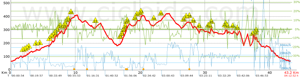
Distance in Km: 43.17
Climb in m: 1365
IBP: 121 BYC

Amuno
Author: Amuno
37 published routes

Add to my Group or Club

 Height in m      Climb in %      Speed in Km/h      Speed < 2 Km/h

Climbs > 5%

Climbs >5% Climbs >10% Climbs >15% Climbs >20% Climbs >25%
 Steep slope of 148 m.   Average slope  Distances  Download as waypoint
1
 Km 1.837  5%  148 m
 Steep slope of 101 m.  Average slope  Distances  Download as waypoint
2
 Km 2.209  7%  101 m
 Steep slope of 110 m.  Average slope  Distances  Download as waypoint
3
 Km 2.452  8%  110 m
 Steep slope of 112 m.  Average slope  Distances  Download as waypoint
4
 Km 2.775  5%  112 m
 Steep slope of 151 m.  Average slope  Distances  Download as waypoint
5
 Km 3.87  8%  151 m
 Steep slope of 142 m.  Average slope  Distances  Download as waypoint
6
 Km 4.456  6%  142 m
 Steep slope of 342 m.  Average slope  Distances  Download as waypoint
7
 Km 6.014  7%  265 m
8
 Km 6.278  13%  77 m
 Steep slope of 295 m.  Average slope  Distances  Download as waypoint
9
 Km 6.619  8%  113 m
10
 Km 6.732  20%  182 m
 Steep slope of 311 m.  Average slope  Distances  Download as waypoint
11
 Km 7.164  8%  37 m
12
 Km 7.201  8%  235 m
13
 Km 7.435  11%  39 m
 Steep slope of 179 m.  Average slope  Distances  Download as waypoint
14
 Km 7.663  8%  179 m
 Steep slope of 554 m.  Average slope  Distances  Download as waypoint
15
 Km 8.192  6%  34 m
16
 Km 8.226  13%  148 m
17
 Km 8.375  8%  262 m
18
 Km 8.637  22%  110 m
 Steep slope of 448 m.  Average slope  Distances  Download as waypoint
19
 Km 8.863  12%  376 m
20
 Km 9.239  11%  72 m
 Steep slope of 156 m.  Average slope  Distances  Download as waypoint
21
 Km 13.089  8%  156 m
 Steep slope of 502 m.  Average slope  Distances  Download as waypoint
22
 Km 16.903  8%  212 m
23
 Km 17.115  13%  252 m
24
 Km 17.367  10%  38 m
 Steep slope of 808 m.  Average slope  Distances  Download as waypoint
25
 Km 17.514  14%  145 m
26
 Km 17.659  17%  179 m
27
 Km 17.838  13%  99 m
28
 Km 17.938  8%  385 m
 Steep slope of 285 m.  Average slope  Distances  Download as waypoint
29
 Km 19.215  13%  248 m
30
 Km 19.463  7%  37 m
 Steep slope of 320 m.  Average slope  Distances  Download as waypoint
31
 Km 19.931  10%  36 m
32
 Km 19.967  14%  141 m
33
 Km 20.109  9%  143 m
 Steep slope of 246 m.  Average slope  Distances  Download as waypoint
34
 Km 22.074  5%  246 m
 Steep slope of 676 m.  Average slope  Distances  Download as waypoint
35
 Km 23.198  6%  676 m
 Steep slope of 308 m.  Average slope  Distances  Download as waypoint
36
 Km 26.655  7%  308 m
 Steep slope of 140 m.  Average slope  Distances  Download as waypoint
37
 Km 27.074  5%  140 m
 Steep slope of 139 m.  Average slope  Distances  Download as waypoint
38
 Km 27.548  7%  139 m
 Steep slope of 166 m.  Average slope  Distances  Download as waypoint
39
 Km 28.195  7%  166 m
 Steep slope of 229 m.  Average slope  Distances  Download as waypoint
40
 Km 29.035  7%  42 m
41
 Km 29.077  15%  187 m
 Steep slope of 111 m.  Average slope  Distances  Download as waypoint
42
 Km 30.416  10%  111 m
 Steep slope of 212 m.  Average slope  Distances  Download as waypoint
43
 Km 30.754  7%  31 m
44
 Km 30.784  20%  144 m
45
 Km 30.928  11%  37 m
 Steep slope of 178 m.  Average slope  Distances  Download as waypoint
46
 Km 33.049  16%  145 m
47
 Km 33.194  6%  33 m
 Steep slope of 144 m.  Average slope  Distances  Download as waypoint
48
 Km 33.51  10%  144 m
 Steep slope of 121 m.  Average slope  Distances  Download as waypoint
49
 Km 34.305  11%  121 m
 Steep slope of 334 m.  Average slope  Distances  Download as waypoint
50
 Km 34.95  9%  334 m
 Steep slope of 161 m.  Average slope  Distances  Download as waypoint
51
 Km 37.201  15%  161 m
 Steep slope of 142 m.  Average slope  Distances  Download as waypoint
52
 Km 37.767  16%  113 m
53
 Km 37.88  9%  29 m


Description of the route


Presence of ramps


 Climbs  Distance  % of the total  Speed  Your speed would be  Time  Your time would be
   15 - 30%  1.923  4.45  11.89  ?  0:09:42  ?
   10 - 15%  2.446  5.67  7.3  ?  0:20:07  ?
   5 - 10%  6.158  14.26  9.46  ?  0:39:04  ?
   1 - 5%  8.734  20.23  11.17  ?  0:46:56  ?
   Total*  19.26 Km  44.61 %  9.98 Km/h  ? Km/h    1:55:49 h  ? h  
 Flat
   1 - -1%  5.088 Km  11.78 %  11.83 Km/h  ? Km/h    0:25:48 h  ? h  
 Descents
   -1 - -5%  7.195  16.66  14.37  ?  0:30:03  ?
   -5 - -10%  7.012  16.24  16.83  ?  0:25:00  ?
   -10 - -15%  2.678  6.2  17.79  ?  0:09:02  ?
   -15 - -30%  1.942  4.5  28.54  ?  0:04:05  ?
   Total*  18.827 Km  43.61 %  16.57 Km/h  ? Km/h    1:08:10 h  ? h  
* The total has not necessarily coincide with the sum of the partials after correction of errors

How long would it take you?

How long would it take you to cover this route?
There are routes without a valid time information, but with your average stats you can assess the possible duration

Amuno to cover this route you've need a time of:   3:29:47 h 
If you sign in and have a minimum of two tracks of this same modality, you can know your time for this route, calculated from your stats..


¿Cuanto consumirá tu E-BIKE?

Entra tu E-IBP (formato n,nn)

E-IBP :   X 121 = 


 Detected activity type =  ()
 Penalization due to track conditions: 81 %   ( > 50 % = MTB, < 50 % = RDB)
 Reliability of the track: C   (1370/57/0/-/-/57)
 Correction level applied to the track: 0
DIFFICULTY OF THE ROUTE
IBP = 121 BYC
According to your statistics
 Your time in motion would be: ? h
Your average speed would be: ? Km/h
 

 Total Distance: 43.17 Km
 Analysed distance: 43.17 Km
 Linear distance: 0.1 Km

 Cumulated positive ramps: 1365.14 m  list of points info
 Cumulated negative ramps: 1362.54 m
 Maximum height: 424.7 m
 Minimum height: 62.9 m
 Climbing Ratio: 7.09 %
 Descent ratio: 7.24 %
 Cumulated postive ramps per Km: 31.62 m
 Cumulated negative ramps per Km: 31.56 m

 Total time: 4:12:52 h
 Time in movement: 3:29:47 h
 According to your statistics
 Your time in motion would be: ? h  
 Stopped time: 0:43:05 h
 Maximum slope filter: ~30 %
 Minimum separation analysed: ~30 m
 Number of points: 2993   (cad. 14.42 m)
 Significant waypoints: 1118   (cad. 38.65 m / 37.35 %)

 Changes in direction per Km: 11.23
 Changes in direction > 5º por Km: 8.59
 Cumulated straight stretches: 5.393 Km
 Straight stretches per Km: 124.92 m
 Penalized slope changes: 13
 Penalized slope changes per Km: 0.301

 Average speed in total: 10.24 Km/h
 Average speed while moving: 12.35 Km/h
 According to your statistics
 Your average speed would be: ? Km/h  
 Maximum sustained speed: 92.7 Km/h


Comments

You can be the first one in commenting this route

 
My comments
:
Add comment  (Registered users)
 
Notify me answers to my comment  Do not notify answers to my comment


Share this route with a friend

Your friend will receive a message with a link to this page:
will see your email and your user name if you do it as registered user.


Write here your name (optional)

E-mail address of your friend(s). You can include various addresses separated by commas

Text or comment (optional) maximum 255 characters long, 255 Available characters

As a non registered users you need to fill-in the captcha text.
  Change image
Type the image characters.
 
 Share with a friend


Visited history

Delete history

Marked routes for review later or compare

My favorites


  Notify anomaly in this route Share in Facebook