__ BTT Casas de Juan Nuñez 2020

MTB
MTB
Ref..: 859462
Published: 16/02/2020
Performed: 16/02/2020
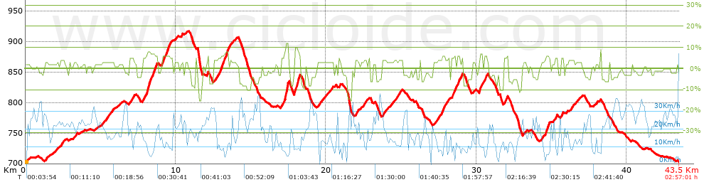
Distance in Km: 43.48
Climb in m: 800
IBP: 44 BYC

YellowSub Irba
814 published routes

Add to my Group or Club

 Height in m      Climb in %      Speed in Km/h      Speed < 2 Km/h

Climbs > 5%

Climbs >5% Climbs >10% Climbs >15% Climbs >20% Climbs >25%
 Steep slope of 775 m.   Average slope  Distances  Download as waypoint
1
 Km 8.009  7%  775 m
 Steep slope of 523 m.  Average slope  Distances  Download as waypoint
2
 Km 9.057  6%  523 m
 Steep slope of 119 m.  Average slope  Distances  Download as waypoint
3
 Km 12.071  6%  119 m
 Steep slope of 550 m.  Average slope  Distances  Download as waypoint
4
 Km 12.996  7%  550 m
 Steep slope of 518 m.  Average slope  Distances  Download as waypoint
5
 Km 16.998  5%  263 m
6
 Km 17.261  12%  219 m
7
 Km 17.48  10%  36 m
 Steep slope of 375 m.  Average slope  Distances  Download as waypoint
8
 Km 17.902  8%  375 m
 Steep slope of 111 m.  Average slope  Distances  Download as waypoint
9
 Km 20.835  5%  111 m
 Steep slope of 223 m.  Average slope  Distances  Download as waypoint
10
 Km 27.654  6%  223 m
 Steep slope of 545 m.  Average slope  Distances  Download as waypoint
11
 Km 28.318  6%  545 m
 Steep slope of 142 m.  Average slope  Distances  Download as waypoint
12
 Km 28.971  5%  142 m
 Steep slope of 221 m.  Average slope  Distances  Download as waypoint
13
 Km 30.177  7%  221 m
 Steep slope of 182 m.  Average slope  Distances  Download as waypoint
14
 Km 30.549  6%  182 m
 Steep slope of 270 m.  Average slope  Distances  Download as waypoint
15
 Km 31.79  5%  270 m
 Steep slope of 259 m.  Average slope  Distances  Download as waypoint
16
 Km 34.556  6%  259 m
 Steep slope of 116 m.  Average slope  Distances  Download as waypoint
17
 Km 35.244  7%  116 m
 Steep slope of 172 m.  Average slope  Distances  Download as waypoint
18
 Km 35.598  5%  172 m


Description of the route


Presence of ramps


 Climbs  Distance  % of the total  Speed  Your speed would be  Time  Your time would be
   15 - 30%  0  0  0  ?  0:00:00  ?
   10 - 15%  0.219  0.5  4.91  ?  0:02:41  ?
   5 - 10%  5.118  11.77  8.79  ?  0:34:57  ?
   1 - 5%  15.499  35.64  15.24  ?  1:01:01  ?
   Total*  20.836 Km  47.92 %  12.67 Km/h  ? Km/h    1:38:39 h  ? h  
 Flat
   1 - -1%  5.228 Km  12.02 %  18.86 Km/h  ? Km/h    0:16:38 h  ? h  
 Descents
   -1 - -5%  11.519  26.49  19.3  ?  0:35:49  ?
   -5 - -10%  5.12  11.77  16.73  ?  0:18:22  ?
   -10 - -15%  0.562  1.29  20.04  ?  0:01:41  ?
   -15 - -30%  0.217  0.5  21.16  ?  0:00:37  ?
   Total*  17.419 Km  40.06 %  18.5 Km/h  ? Km/h    0:56:29 h  ? h  
* The total has not necessarily coincide with the sum of the partials after correction of errors

How long would it take you?

How long would it take you to cover this route?
There are routes without a valid time information, but with your average stats you can assess the possible duration

YellowSub Irba to cover this route you've need a time of:   2:51:46 h 
If you sign in and have a minimum of two tracks of this same modality, you can know your time for this route, calculated from your stats..


¿Cuanto consumirá tu E-BIKE?

Entra tu E-IBP (formato n,nn)

E-IBP :   X 44 = 


 Detected activity type =  ()
 Penalization due to track conditions: 60 %   ( > 50 % = MTB, < 50 % = RDB)
 Reliability of the track: C   (883/51/1/16/-/70)
 Correction level applied to the track: 1        See analyis without corrections
DIFFICULTY OF THE ROUTE
IBP = 44 BYC
According to your statistics
 Your time in motion would be: ? h
Your average speed would be: ? Km/h
 

 Total Distance: 43.48 Km
 Analysed distance: 43.48 Km
 Linear distance: 0.01 Km

 Cumulated positive ramps: 799.57 m  list of points info
 Cumulated negative ramps: 800.02 m
 Maximum height: 916.71 m
 Minimum height: 702.7 m
 Climbing Ratio: 3.84 %
 Descent ratio: 4.59 %
 Cumulated postive ramps per Km: 18.39 m
 Cumulated negative ramps per Km: 18.4 m

 Total time: 2:57:01 h
 Time in movement: 2:51:46 h
 According to your statistics
 Your time in motion would be: ? h  
 Stopped time: 0:05:15 h
 Maximum slope filter: ~30 %
 Minimum separation analysed: ~30 m
 Number of points: 3055   (cad. 14.23 m)
 Significant waypoints: 1163   (cad. 37.39 m / 38.07 %)

 Changes in direction per Km: 10.72
 Changes in direction > 5º por Km: 7.96
 Cumulated straight stretches: 9.2 Km
 Straight stretches per Km: 211.59 m
 Penalized slope changes: 8
 Penalized slope changes per Km: 0.184

 Average speed in total: 14.74 Km/h
 Average speed while moving: 15.19 Km/h
 According to your statistics
 Your average speed would be: ? Km/h  
 Maximum sustained speed: 42.03 Km/h


Comments

You can be the first one in commenting this route

 
My comments
:
Add comment  (Registered users)
 
Notify me answers to my comment  Do not notify answers to my comment


Share this route with a friend

Your friend will receive a message with a link to this page:
will see your email and your user name if you do it as registered user.


Write here your name (optional)

E-mail address of your friend(s). You can include various addresses separated by commas

Text or comment (optional) maximum 255 characters long, 255 Available characters

As a non registered users you need to fill-in the captcha text.
  Change image
Type the image characters.
 
 Share with a friend


Visited history

Delete history

Marked routes for review later or compare

My favorites


  Notify anomaly in this route Share in Facebook