Olesa-Monistrol-castellvell I el Vilar-casi Marganell-Font Dona Morta-Monistrol-Olesa

MTB
MTB
Ref..: 857901
Published: 09/02/2020
Performed: 09/02/2020
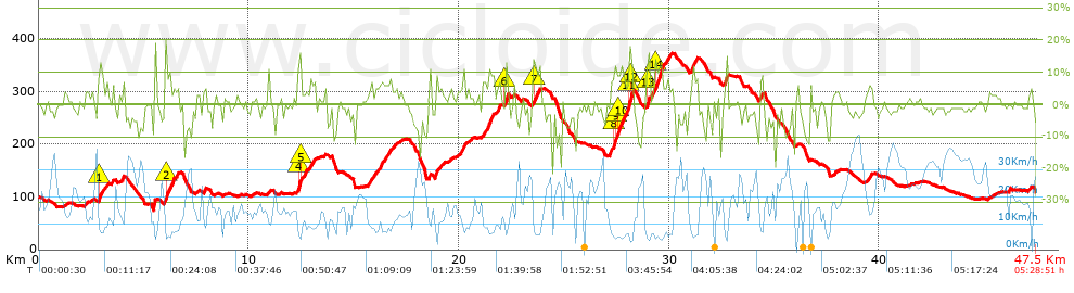
Distance in Km: 47.53
Climb in m: 955
IBP: 79 BYC

Near ...
Abrera, Castellgali, Esparreguera, Olesa De Montserrat, Santa Maria De Vilalba

 Height in m      Climb in %      Speed in Km/h      Speed < 2 Km/h

Climbs > 5%

Climbs >5% Climbs >10% Climbs >15% Climbs >20% Climbs >25%
 Steep slope of 254 m.   Average slope  Distances  Download as waypoint
1
 Km 2.834  8%  39 m
2
 Km 2.873  13%  105 m
3
 Km 2.978  9%  110 m
 Steep slope of 116 m.  Average slope  Distances  Download as waypoint
4
 Km 5.471  16%  116 m
 Steep slope of 436 m.  Average slope  Distances  Download as waypoint
5
 Km 5.997  5%  34 m
6
 Km 6.031  13%  220 m
7
 Km 6.251  9%  182 m
 Steep slope of 111 m.  Average slope  Distances  Download as waypoint
8
 Km 6.554  7%  111 m
 Steep slope of 334 m.  Average slope  Distances  Download as waypoint
9
 Km 12.329  11%  37 m
10
 Km 12.366  17%  104 m
11
 Km 12.47  11%  30 m
12
 Km 12.5  5%  163 m
 Steep slope of 289 m.  Average slope  Distances  Download as waypoint
13
 Km 12.88  7%  289 m
 Steep slope of 174 m.  Average slope  Distances  Download as waypoint
14
 Km 15.682  6%  174 m
 Steep slope of 137 m.  Average slope  Distances  Download as waypoint
15
 Km 15.971  6%  137 m
 Steep slope of 544 m.  Average slope  Distances  Download as waypoint
16
 Km 16.22  6%  544 m
 Steep slope of 291 m.  Average slope  Distances  Download as waypoint
17
 Km 18.866  8%  291 m
 Steep slope of 246 m.  Average slope  Distances  Download as waypoint
18
 Km 20.1  7%  246 m
 Steep slope of 548 m.  Average slope  Distances  Download as waypoint
19
 Km 21.098  8%  548 m
 Steep slope of 115 m.  Average slope  Distances  Download as waypoint
20
 Km 21.875  10%  115 m
 Steep slope of 149 m.  Average slope  Distances  Download as waypoint
21
 Km 22.186  14%  149 m
 Steep slope of 307 m.  Average slope  Distances  Download as waypoint
22
 Km 23.548  11%  127 m
23
 Km 23.675  10%  180 m
 Steep slope of 1002 m.  Average slope  Distances  Download as waypoint
24
 Km 27.205  10%  147 m
25
 Km 27.352  12%  109 m
26
 Km 27.461  11%  100 m
27
 Km 27.561  12%  190 m
28
 Km 27.752  8%  319 m
29
 Km 28.071  13%  69 m
30
 Km 28.14  17%  68 m
 Steep slope of 64 m.  Average slope  Distances  Download as waypoint
31
 Km 28.245  7%  64 m
 Steep slope of 284 m.  Average slope  Distances  Download as waypoint
32
 Km 28.941  13%  145 m
33
 Km 29.086  6%  139 m
 Steep slope of 644 m.  Average slope  Distances  Download as waypoint
34
 Km 29.335  12%  330 m
35
 Km 29.665  7%  314 m
 Steep slope of 243 m.  Average slope  Distances  Download as waypoint
36
 Km 31.062  9%  243 m
 Steep slope of 180 m.  Average slope  Distances  Download as waypoint
37
 Km 32.658  10%  180 m
 Steep slope of 185 m.  Average slope  Distances  Download as waypoint
38
 Km 34.292  6%  185 m
 Steep slope of 114 m.  Average slope  Distances  Download as waypoint
39
 Km 39.479  6%  114 m


Description of the route


Presence of ramps


 Climbs  Distance  % of the total  Speed  Your speed would be  Time  Your time would be
   15 - 30%  0.688  1.45  5.69  ?  0:07:15  ?
   10 - 15%  2.039  4.29  6.78  ?  0:18:02  ?
   5 - 10%  4.785  10.07  8.57  ?  0:33:31  ?
   1 - 5%  9.118  19.18  12.84  ?  0:42:36  ?
   Total*  16.629 Km  34.99 %  9.84 Km/h  ? Km/h    1:41:24 h  ? h  
 Flat
   1 - -1%  11.73 Km  24.68 %  18.62 Km/h  ? Km/h    0:37:48 h  ? h  
 Descents
   -1 - -5%  12.663  26.64  21.63  ?  0:35:08  ?
   -5 - -10%  4.386  9.23  21.87  ?  0:12:02  ?
   -10 - -15%  1.472  3.1  16.99  ?  0:05:12  ?
   -15 - -30%  0.653  1.37  13.74  ?  0:02:51  ?
   Total*  19.174 Km  40.34 %  20.83 Km/h  ? Km/h    0:55:13 h  ? h  
* The total has not necessarily coincide with the sum of the partials after correction of errors

How long would it take you?

How long would it take you to cover this route?
There are routes without a valid time information, but with your average stats you can assess the possible duration

PLATO PEQUEÑO to cover this route you've need a time of:   3:14:25 h 
If you sign in and have a minimum of two tracks of this same modality, you can know your time for this route, calculated from your stats..


¿Cuanto consumirá tu E-BIKE?

Entra tu E-IBP (formato n,nn)

E-IBP :   X 79 = 


 Detected activity type =  ()
 Penalization due to track conditions: 70 %   ( > 50 % = MTB, < 50 % = RDB)
 Reliability of the track: B   (955/63/0/-/-/63)
 Correction level applied to the track: 0
DIFFICULTY OF THE ROUTE
IBP = 79 BYC
According to your statistics
 Your time in motion would be: ? h
Your average speed would be: ? Km/h
 

 Total Distance: 47.53 Km
 Analysed distance: 47.53 Km
 Linear distance: 0.01 Km

 Cumulated positive ramps: 955.2 m  list of points info
 Cumulated negative ramps: 942.34 m
 Maximum height: 372.4 m
 Minimum height: 75.4 m
 Climbing Ratio: 5.74 %
 Descent ratio: 4.91 %
 Cumulated postive ramps per Km: 20.1 m
 Cumulated negative ramps per Km: 19.83 m

 Total time: 5:28:51 h
 Time in movement: 3:14:25 h
 According to your statistics
 Your time in motion would be: ? h  
 Stopped time: 2:14:26 h
 Maximum slope filter: ~30 %
 Minimum separation analysed: ~30 m
 Number of points: 2434   (cad. 19.53 m)
 Significant waypoints: 1165   (cad. 40.8 m / 47.86 %)

 Changes in direction per Km: 9.74
 Changes in direction > 5º por Km: 7.26
 Cumulated straight stretches: 8.147 Km
 Straight stretches per Km: 171.41 m
 Penalized slope changes: 10
 Penalized slope changes per Km: 0.21

 Average speed in total: 8.67 Km/h
 Average speed while moving: 14.67 Km/h
 According to your statistics
 Your average speed would be: ? Km/h  
 Maximum sustained speed: 44.18 Km/h


Comments

You can be the first one in commenting this route

 
My comments
:
Add comment  (Registered users)
 
Notify me answers to my comment  Do not notify answers to my comment


Share this route with a friend

Your friend will receive a message with a link to this page:
will see your email and your user name if you do it as registered user.


Write here your name (optional)

E-mail address of your friend(s). You can include various addresses separated by commas

Text or comment (optional) maximum 255 characters long, 255 Available characters

As a non registered users you need to fill-in the captcha text.
  Change image
Type the image characters.
 
 Share with a friend


Visited history

Delete history

Marked routes for review later or compare

My favorites


  Notify anomaly in this route Share in Facebook