Sierra del Almuerzo

Road
Road
Ref..: 852225
Published: 05/01/2020
Performed: 04/01/2020
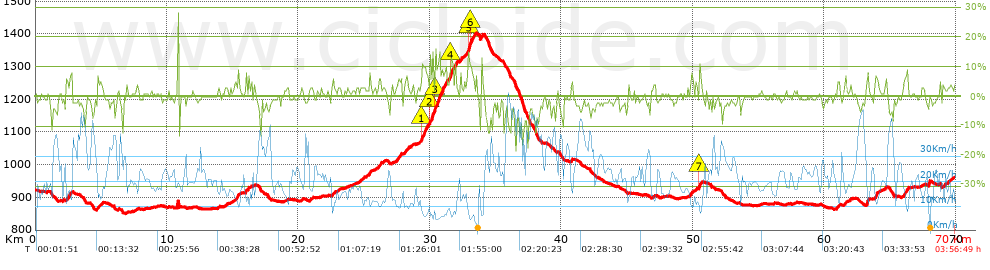
Distance in Km: 69.96
Climb in m: 1008
IBP: 67 BYC


 Height in m      Climb in %      Speed in Km/h      Speed < 2 Km/h

Climbs > 5%

Climbs >5% Climbs >10% Climbs >15% Climbs >20% Climbs >25%
 Steep slope of 333 m.   Average slope  Distances  Download as waypoint
1
 Km 2.345  6%  333 m
 Steep slope of 116 m.  Average slope  Distances  Download as waypoint
2
 Km 22.595  6%  116 m
 Steep slope of 161 m.  Average slope  Distances  Download as waypoint
3
 Km 25.386  7%  161 m
 Steep slope of 210 m.  Average slope  Distances  Download as waypoint
4
 Km 26.133  6%  210 m
 Steep slope of 263 m.  Average slope  Distances  Download as waypoint
5
 Km 27.509  6%  263 m
 Steep slope of 154 m.  Average slope  Distances  Download as waypoint
6
 Km 28.08  5%  154 m
 Steep slope of 502 m.  Average slope  Distances  Download as waypoint
7
 Km 29.371  8%  41 m
8
 Km 29.412  10%  224 m
9
 Km 29.636  8%  237 m
 Steep slope of 1217 m.  Average slope  Distances  Download as waypoint
10
 Km 30.017  11%  218 m
11
 Km 30.235  8%  170 m
12
 Km 30.405  13%  191 m
13
 Km 30.596  9%  638 m
 Steep slope of 463 m.  Average slope  Distances  Download as waypoint
14
 Km 31.49  7%  78 m
15
 Km 31.568  12%  216 m
16
 Km 31.784  7%  169 m
 Steep slope of 95 m.  Average slope  Distances  Download as waypoint
17
 Km 32.332  9%  95 m
 Steep slope of 641 m.  Average slope  Distances  Download as waypoint
18
 Km 32.847  8%  71 m
19
 Km 32.919  16%  115 m
20
 Km 33.034  10%  121 m
21
 Km 33.155  7%  334 m
 Steep slope of 241 m.  Average slope  Distances  Download as waypoint
22
 Km 49.767  5%  241 m
 Steep slope of 186 m.  Average slope  Distances  Download as waypoint
23
 Km 50.475  12%  106 m
24
 Km 50.581  7%  80 m
 Steep slope of 211 m.  Average slope  Distances  Download as waypoint
25
 Km 60.995  5%  211 m
 Steep slope of 125 m.  Average slope  Distances  Download as waypoint
26
 Km 61.587  6%  125 m
 Steep slope of 203 m.  Average slope  Distances  Download as waypoint
27
 Km 63.216  8%  203 m
 Steep slope of 187 m.  Average slope  Distances  Download as waypoint
28
 Km 63.897  7%  187 m
 Steep slope of 375 m.  Average slope  Distances  Download as waypoint
29
 Km 66.05  7%  375 m


Description of the route


Presence of ramps


 Climbs  Distance  % of the total  Speed  Your speed would be  Time  Your time would be
   15 - 30%  0.374  0.53  7.73  ?  0:02:54  ?
   10 - 15%  1.389  1.99  7.88  ?  0:10:35  ?
   5 - 10%  5.28  7.55  10.82  ?  0:29:17  ?
   1 - 5%  16.824  24.05  15.59  ?  1:04:45  ?
   Total*  23.867 Km  34.12 %  13.32 Km/h  ? Km/h    1:47:31 h  ? h  
 Flat
   1 - -1%  21.626 Km  30.91 %  21.22 Km/h  ? Km/h    1:01:08 h  ? h  
 Descents
   -1 - -5%  18.445  26.37  27.03  ?  0:40:57  ?
   -5 - -10%  4.47  6.39  32.91  ?  0:08:09  ?
   -10 - -15%  1.312  1.88  28.12  ?  0:02:48  ?
   -15 - -30%  0.238  0.34  13.59  ?  0:01:03  ?
   Total*  24.465 Km  34.97 %  27.72 Km/h  ? Km/h    0:52:57 h  ? h  
* The total has not necessarily coincide with the sum of the partials after correction of errors

How long would it take you?

How long would it take you to cover this route?
There are routes without a valid time information, but with your average stats you can assess the possible duration

Ricardo Tutor (BTTSoria) to cover this route you've need a time of:   3:41:36 h 
If you sign in and have a minimum of two tracks of this same modality, you can know your time for this route, calculated from your stats..


¿Cuanto consumirá tu E-BIKE?

Entra tu E-IBP (formato n,nn)

E-IBP :   X 67 = 


 Detected activity type =  ()
 Penalization due to track conditions: 34 %   ( > 50 % = MTB, < 50 % = RDB)
 Reliability of the track: A   (1024/72/0/-/-/72)
 Correction level applied to the track: 0
DIFFICULTY OF THE ROUTE
IBP = 67 BYC
According to your statistics
 Your time in motion would be: ? h
Your average speed would be: ? Km/h
 

 Total Distance: 69.96 Km
 Analysed distance: 69.96 Km
 Linear distance: 0.16 Km

 Cumulated positive ramps: 1007.56 m  list of points info
 Cumulated negative ramps: 957.76 m
 Maximum height: 1403.2 m
 Minimum height: 850.8 m
 Climbing Ratio: 4.22 %
 Descent ratio: 3.91 %
 Cumulated postive ramps per Km: 14.4 m
 Cumulated negative ramps per Km: 13.69 m

 Total time: 3:56:49 h
 Time in movement: 3:41:36 h
 According to your statistics
 Your time in motion would be: ? h  
 Stopped time: 0:15:13 h
 Maximum slope filter: ~30 %
 Minimum separation analysed: ~30 m
 Number of points: 2257   (cad. 31 m)
 Significant waypoints: 1427   (cad. 49.02 m / 63.23 %)

 Changes in direction per Km: 7.4
 Changes in direction > 5º por Km: 4.26
 Cumulated straight stretches: 25.108 Km
 Straight stretches per Km: 358.89 m
 Penalized slope changes: 7
 Penalized slope changes per Km: 0.1

 Average speed in total: 17.72 Km/h
 Average speed while moving: 18.94 Km/h
 According to your statistics
 Your average speed would be: ? Km/h  
 Maximum sustained speed: 56.89 Km/h


Comments

You can be the first one in commenting this route

 
My comments
:
Add comment  (Registered users)
 
Notify me answers to my comment  Do not notify answers to my comment


Share this route with a friend

Your friend will receive a message with a link to this page:
will see your email and your user name if you do it as registered user.


Write here your name (optional)

E-mail address of your friend(s). You can include various addresses separated by commas

Text or comment (optional) maximum 255 characters long, 255 Available characters

As a non registered users you need to fill-in the captcha text.
  Change image
Type the image characters.
 
 Share with a friend


Visited history

Delete history

Marked routes for review later or compare

My favorites


  Notify anomaly in this route Share in Facebook