190916 Salida BTT

MTB
MTB
Ref..: 846622
Published: 27/11/2019
Performed: 16/09/2019
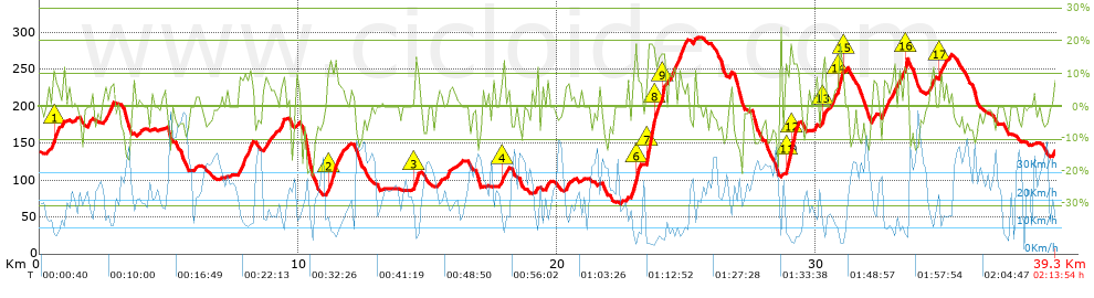
Distance in Km: 39.26
Climb in m: 1034
IBP: 94 BYC

Near ...
Abuli, Arquera, La (Oviedo), Atrollo, El, Barredos, Los (Manjoya-Oviedo), Bueño (Ribera De Arriba), Caleyo, El (Ribera De Arriba)
Olbap_AG
Author: Olbap_AG
358 published routes

Add to my Group or Club

 Height in m      Climb in %      Speed in Km/h      Speed < 2 Km/h

Climbs > 5%

Climbs >5% Climbs >10% Climbs >15% Climbs >20% Climbs >25%
 Steep slope of 129 m.   Average slope  Distances  Download as waypoint
1
 Km 0.292  5%  129 m
 Steep slope of 257 m.  Average slope  Distances  Download as waypoint
2
 Km 0.519  10%  147 m
3
 Km 0.666  8%  110 m
 Steep slope of 104 m.  Average slope  Distances  Download as waypoint
4
 Km 1.851  7%  104 m
 Steep slope of 346 m.  Average slope  Distances  Download as waypoint
5
 Km 2.483  7%  346 m
 Steep slope of 549 m.  Average slope  Distances  Download as waypoint
6
 Km 7.721  8%  549 m
 Steep slope of 220 m.  Average slope  Distances  Download as waypoint
7
 Km 8.716  6%  220 m
 Steep slope of 91 m.  Average slope  Distances  Download as waypoint
8
 Km 9.061  5%  91 m
 Steep slope of 179 m.  Average slope  Distances  Download as waypoint
9
 Km 9.292  8%  179 m
 Steep slope of 514 m.  Average slope  Distances  Download as waypoint
10
 Km 11.122  6%  72 m
11
 Km 11.194  12%  285 m
12
 Km 11.479  8%  157 m
 Steep slope of 143 m.  Average slope  Distances  Download as waypoint
13
 Km 14.501  12%  143 m
 Steep slope of 123 m.  Average slope  Distances  Download as waypoint
14
 Km 15.768  6%  123 m
 Steep slope of 71 m.  Average slope  Distances  Download as waypoint
15
 Km 17.88  13%  71 m
 Steep slope of 105 m.  Average slope  Distances  Download as waypoint
16
 Km 19.603  9%  105 m
 Steep slope of 137 m.  Average slope  Distances  Download as waypoint
17
 Km 20.323  8%  137 m
 Steep slope of 294 m.  Average slope  Distances  Download as waypoint
18
 Km 22.89  9%  144 m
19
 Km 23.035  19%  32 m
20
 Km 23.067  18%  71 m
21
 Km 23.138  8%  47 m
 Steep slope of 703 m.  Average slope  Distances  Download as waypoint
22
 Km 23.459  18%  315 m
23
 Km 23.773  12%  124 m
24
 Km 23.897  7%  125 m
25
 Km 24.022  18%  139 m
 Steep slope of 223 m.  Average slope  Distances  Download as waypoint
26
 Km 24.347  7%  144 m
27
 Km 24.491  11%  79 m
 Steep slope of 324 m.  Average slope  Distances  Download as waypoint
28
 Km 24.682  11%  72 m
29
 Km 24.754  8%  252 m
 Steep slope of 519 m.  Average slope  Distances  Download as waypoint
30
 Km 28.845  13%  40 m
31
 Km 28.884  16%  186 m
32
 Km 29.071  15%  168 m
33
 Km 29.239  11%  125 m
 Steep slope of 222 m.  Average slope  Distances  Download as waypoint
34
 Km 30.224  13%  144 m
35
 Km 30.368  5%  78 m
 Steep slope of 118 m.  Average slope  Distances  Download as waypoint
36
 Km 30.595  6%  118 m
 Steep slope of 214 m.  Average slope  Distances  Download as waypoint
37
 Km 30.839  8%  70 m
38
 Km 30.909  19%  104 m
39
 Km 31.014  11%  40 m
 Steep slope of 152 m.  Average slope  Distances  Download as waypoint
40
 Km 32.209  7%  152 m
 Steep slope of 485 m.  Average slope  Distances  Download as waypoint
41
 Km 32.555  7%  485 m
 Steep slope of 316 m.  Average slope  Distances  Download as waypoint
42
 Km 33.173  7%  240 m
43
 Km 33.414  15%  76 m
 Steep slope of 143 m.  Average slope  Distances  Download as waypoint
44
 Km 34.501  9%  143 m
 Steep slope of 248 m.  Average slope  Distances  Download as waypoint
45
 Km 34.755  11%  106 m
46
 Km 34.861  5%  142 m
 Steep slope of 96 m.  Average slope  Distances  Download as waypoint
47
 Km 35.099  5%  96 m


Description of the route


Presence of ramps


 Climbs  Distance  % of the total  Speed  Your speed would be  Time  Your time would be
   15 - 30%  1.144  2.91  6.17  ?  0:11:08  ?
   10 - 15%  2.408  6.13  9.55  ?  0:15:08  ?
   5 - 10%  5.383  13.71  13.16  ?  0:24:32  ?
   1 - 5%  5.199  13.24  16.74  ?  0:18:38  ?
   Total*  14.134 Km  36 %  12.21 Km/h  ? Km/h    1:09:26 h  ? h  
 Flat
   1 - -1%  10.03 Km  25.55 %  19.27 Km/h  ? Km/h    0:31:14 h  ? h  
 Descents
   -1 - -5%  5.673  14.45  28.36  ?  0:12:00  ?
   -5 - -10%  6.239  15.89  27.09  ?  0:13:49  ?
   -10 - -15%  2.485  6.33  32.65  ?  0:04:34  ?
   -15 - -30%  0.701  1.78  14.75  ?  0:02:51  ?
   Total*  15.097 Km  38.45 %  27.26 Km/h  ? Km/h    0:33:14 h  ? h  
* The total has not necessarily coincide with the sum of the partials after correction of errors

How long would it take you?

How long would it take you to cover this route?
There are routes without a valid time information, but with your average stats you can assess the possible duration

Olbap_AG to cover this route you've need a time of:   2:13:54 h 
If you sign in and have a minimum of two tracks of this same modality, you can know your time for this route, calculated from your stats..


¿Cuanto consumirá tu E-BIKE?

Entra tu E-IBP (formato n,nn)

E-IBP :   X 94 = 


 Detected activity type =  ()
 Penalization due to track conditions: 74 %   ( > 50 % = MTB, < 50 % = RDB)
 Reliability of the track: A   (1033/72/0/-/-/72)
 Correction level applied to the track: 0
DIFFICULTY OF THE ROUTE
IBP = 94 BYC
According to your statistics
 Your time in motion would be: ? h
Your average speed would be: ? Km/h
 

 Total Distance: 39.26 Km
 Analysed distance: 39.26 Km
 Linear distance: 0.23 Km

 Cumulated positive ramps: 1033.6 m  list of points info
 Cumulated negative ramps: 1031.8 m
 Maximum height: 293.2 m
 Minimum height: 67.8 m
 Climbing Ratio: 7.31 %
 Descent ratio: 6.83 %
 Cumulated postive ramps per Km: 26.33 m
 Cumulated negative ramps per Km: 26.28 m

 Total time: 2:13:54 h
 Time in movement: 2:13:54 h
 According to your statistics
 Your time in motion would be: ? h  
 Stopped time: 0:00:00 h
 Maximum slope filter: ~30 %
 Minimum separation analysed: ~30 m
 Number of points: 2367   (cad. 16.59 m)
 Significant waypoints: 1021   (cad. 38.45 m / 43.13 %)

 Changes in direction per Km: 11.36
 Changes in direction > 5º por Km: 8.91
 Cumulated straight stretches: 4.667 Km
 Straight stretches per Km: 118.87 m
 Penalized slope changes: 11
 Penalized slope changes per Km: 0.28

 Average speed in total: 17.59 Km/h
 Average speed while moving: 17.59 Km/h
 According to your statistics
 Your average speed would be: ? Km/h  
 Maximum sustained speed: 53.89 Km/h


Comments

You can be the first one in commenting this route

 
My comments
:
Add comment  (Registered users)
 
Notify me answers to my comment  Do not notify answers to my comment


Share this route with a friend

Your friend will receive a message with a link to this page:
will see your email and your user name if you do it as registered user.


Write here your name (optional)

E-mail address of your friend(s). You can include various addresses separated by commas

Text or comment (optional) maximum 255 characters long, 255 Available characters

As a non registered users you need to fill-in the captcha text.
  Change image
Type the image characters.
 
 Share with a friend


Visited history

Delete history

Marked routes for review later or compare

My favorites


  Notify anomaly in this route Share in Facebook