2019-11-26 15:21

MTB
MTB
Ref..: 846592
Published: 26/11/2019
Performed: 26/11/2019
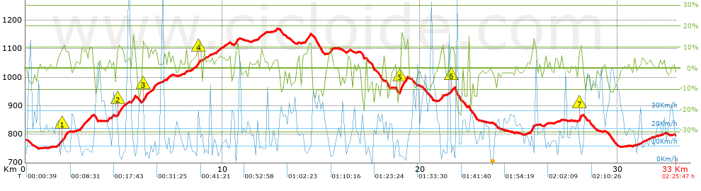
Distance in Km: 33.03
Climb in m: 847
IBP: 65 BYC


 Height in m      Climb in %      Speed in Km/h      Speed < 2 Km/h

Climbs > 5%

Climbs >5% Climbs >10% Climbs >15% Climbs >20% Climbs >25%
 Steep slope of 517 m.   Average slope  Distances  Download as waypoint
1
 Km 1.659  7%  218 m
2
 Km 1.877  11%  171 m
3
 Km 2.048  8%  128 m
 Steep slope of 587 m.  Average slope  Distances  Download as waypoint
4
 Km 2.766  8%  587 m
 Steep slope of 200 m.  Average slope  Distances  Download as waypoint
5
 Km 4.157  5%  200 m
 Steep slope of 418 m.  Average slope  Distances  Download as waypoint
6
 Km 4.616  8%  44 m
7
 Km 4.66  11%  211 m
8
 Km 4.871  8%  163 m
 Steep slope of 216 m.  Average slope  Distances  Download as waypoint
9
 Km 5.374  10%  216 m
 Steep slope of 393 m.  Average slope  Distances  Download as waypoint
10
 Km 5.921  12%  178 m
11
 Km 6.099  7%  215 m
 Steep slope of 224 m.  Average slope  Distances  Download as waypoint
12
 Km 6.442  10%  224 m
 Steep slope of 226 m.  Average slope  Distances  Download as waypoint
13
 Km 7.047  6%  226 m
 Steep slope of 244 m.  Average slope  Distances  Download as waypoint
14
 Km 8.609  7%  86 m
15
 Km 8.695  11%  158 m
 Steep slope of 259 m.  Average slope  Distances  Download as waypoint
16
 Km 9.66  6%  259 m
 Steep slope of 187 m.  Average slope  Distances  Download as waypoint
17
 Km 10.636  10%  187 m
 Steep slope of 221 m.  Average slope  Distances  Download as waypoint
18
 Km 11.756  6%  221 m
 Steep slope of 248 m.  Average slope  Distances  Download as waypoint
19
 Km 14.166  9%  203 m
20
 Km 14.369  12%  45 m
 Steep slope of 215 m.  Average slope  Distances  Download as waypoint
21
 Km 15.331  8%  215 m
 Steep slope of 422 m.  Average slope  Distances  Download as waypoint
22
 Km 18.956  14%  378 m
23
 Km 19.334  14%  44 m
 Steep slope of 167 m.  Average slope  Distances  Download as waypoint
24
 Km 21.004  10%  167 m
 Steep slope of 131 m.  Average slope  Distances  Download as waypoint
25
 Km 21.528  11%  131 m
 Steep slope of 257 m.  Average slope  Distances  Download as waypoint
26
 Km 25.604  10%  257 m
 Steep slope of 210 m.  Average slope  Distances  Download as waypoint
27
 Km 28.012  8%  40 m
28
 Km 28.052  13%  128 m
29
 Km 28.18  5%  42 m


Description of the route


Presence of ramps


 Climbs  Distance  % of the total  Speed  Your speed would be  Time  Your time would be
   15 - 30%  0.225  0.68  8.27  ?  0:01:38  ?
   10 - 15%  2.075  6.28  8.59  ?  0:14:30  ?
   5 - 10%  4.479  13.56  8.41  ?  0:31:57  ?
   1 - 5%  8.12  24.58  14.28  ?  0:34:07  ?
   Total*  14.9 Km  45.1 %  10.88 Km/h  ? Km/h    1:22:12 h  ? h  
 Flat
   1 - -1%  4.758 Km  14.4 %  17.8 Km/h  ? Km/h    0:16:02 h  ? h  
 Descents
   -1 - -5%  6.269  18.98  17.27  ?  0:21:47  ?
   -5 - -10%  4.434  13.42  27.38  ?  0:09:43  ?
   -10 - -15%  2.11  6.39  18.95  ?  0:06:41  ?
   -15 - -30%  0.562  1.7  16.46  ?  0:02:03  ?
   Total*  13.376 Km  40.49 %  19.95 Km/h  ? Km/h    0:40:14 h  ? h  
* The total has not necessarily coincide with the sum of the partials after correction of errors

How long would it take you?

How long would it take you to cover this route?
There are routes without a valid time information, but with your average stats you can assess the possible duration

Fernando_Ramírez_Torrado to cover this route you've need a time of:   2:18:28 h 
If you sign in and have a minimum of two tracks of this same modality, you can know your time for this route, calculated from your stats..


¿Cuanto consumirá tu E-BIKE?

Entra tu E-IBP (formato n,nn)

E-IBP :   X 65 = 


 Detected activity type =  ()
 Penalization due to track conditions: 73 %   ( > 50 % = MTB, < 50 % = RDB)
 Reliability of the track: B   (847/61/0/-/-/61)
 Correction level applied to the track: 0
DIFFICULTY OF THE ROUTE
IBP = 65 BYC
According to your statistics
 Your time in motion would be: ? h
Your average speed would be: ? Km/h
 

 Total Distance: 33.03 Km
 Analysed distance: 33.03 Km
 Linear distance: 0.02 Km

 Cumulated positive ramps: 846.8 m  list of points info
 Cumulated negative ramps: 848.8 m
 Maximum height: 1170.1 m
 Minimum height: 749.5 m
 Climbing Ratio: 5.68 %
 Descent ratio: 6.35 %
 Cumulated postive ramps per Km: 25.64 m
 Cumulated negative ramps per Km: 25.7 m

 Total time: 2:25:47 h
 Time in movement: 2:18:28 h
 According to your statistics
 Your time in motion would be: ? h  
 Stopped time: 0:07:19 h
 Maximum slope filter: ~30 %
 Minimum separation analysed: ~30 m
 Number of points: 1294   (cad. 25.53 m)
 Significant waypoints: 686   (cad. 48.15 m / 53.01 %)

 Changes in direction per Km: 10.05
 Changes in direction > 5º por Km: 8.48
 Cumulated straight stretches: 4.056 Km
 Straight stretches per Km: 122.8 m
 Penalized slope changes: 9
 Penalized slope changes per Km: 0.272

 Average speed in total: 13.6 Km/h
 Average speed while moving: 14.31 Km/h
 According to your statistics
 Your average speed would be: ? Km/h  
 Maximum sustained speed: 58.9 Km/h


Comments

You can be the first one in commenting this route

 
My comments
:
Add comment  (Registered users)
 
Notify me answers to my comment  Do not notify answers to my comment


Share this route with a friend

Your friend will receive a message with a link to this page:
will see your email and your user name if you do it as registered user.


Write here your name (optional)

E-mail address of your friend(s). You can include various addresses separated by commas

Text or comment (optional) maximum 255 characters long, 255 Available characters

As a non registered users you need to fill-in the captcha text.
  Change image
Type the image characters.
 
 Share with a friend


Visited history

Delete history

Marked routes for review later or compare

My favorites


  Notify anomaly in this route Share in Facebook