2019-10-12 Curris y más curris. San Quirico Safaja

MTB
MTB
Ref..: 844804
Published: 15/10/2019
Performed: 12/10/2019
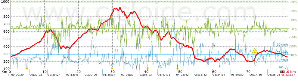
Distance in Km: 81.61
Climb in m: 1980
IBP: 142 BYC

Jordi Tello
Author: Jordi Tello
335 published routes

Add to my Group or Club

 Height in m      Climb in %      Speed in Km/h      Speed < 2 Km/h

Climbs > 5%

Climbs >5% Climbs >10% Climbs >15% Climbs >20% Climbs >25%
 Steep slope of 144 m.   Average slope  Distances  Download as waypoint
1
 Km 2.775  7%  144 m
 Steep slope of 119 m.  Average slope  Distances  Download as waypoint
2
 Km 3.091  5%  119 m
 Steep slope of 151 m.  Average slope  Distances  Download as waypoint
3
 Km 7.656  7%  151 m
 Steep slope of 137 m.  Average slope  Distances  Download as waypoint
4
 Km 8.398  8%  137 m
 Steep slope of 336 m.  Average slope  Distances  Download as waypoint
5
 Km 8.784  8%  336 m
 Steep slope of 103 m.  Average slope  Distances  Download as waypoint
6
 Km 9.478  10%  103 m
 Steep slope of 795 m.  Average slope  Distances  Download as waypoint
7
 Km 9.695  8%  73 m
8
 Km 9.768  12%  294 m
9
 Km 10.061  9%  428 m
 Steep slope of 107 m.  Average slope  Distances  Download as waypoint
10
 Km 10.928  6%  107 m
 Steep slope of 365 m.  Average slope  Distances  Download as waypoint
11
 Km 11.233  7%  220 m
12
 Km 11.453  10%  107 m
13
 Km 11.56  11%  38 m
 Steep slope of 255 m.  Average slope  Distances  Download as waypoint
14
 Km 14.905  5%  75 m
15
 Km 14.981  13%  146 m
16
 Km 15.127  14%  34 m
 Steep slope of 173 m.  Average slope  Distances  Download as waypoint
17
 Km 16.287  9%  173 m
 Steep slope of 260 m.  Average slope  Distances  Download as waypoint
18
 Km 17.511  7%  260 m
 Steep slope of 183 m.  Average slope  Distances  Download as waypoint
19
 Km 17.904  10%  107 m
20
 Km 18.011  11%  76 m
 Steep slope of 148 m.  Average slope  Distances  Download as waypoint
21
 Km 18.393  7%  148 m
 Steep slope of 154 m.  Average slope  Distances  Download as waypoint
22
 Km 18.77  7%  154 m
 Steep slope of 257 m.  Average slope  Distances  Download as waypoint
23
 Km 19.509  7%  257 m
 Steep slope of 288 m.  Average slope  Distances  Download as waypoint
24
 Km 20.697  9%  288 m
 Steep slope of 104 m.  Average slope  Distances  Download as waypoint
25
 Km 21.199  8%  104 m
 Steep slope of 327 m.  Average slope  Distances  Download as waypoint
26
 Km 22.634  11%  177 m
27
 Km 22.812  7%  150 m
 Steep slope of 96 m.  Average slope  Distances  Download as waypoint
28
 Km 23.29  5%  96 m
 Steep slope of 832 m.  Average slope  Distances  Download as waypoint
29
 Km 25.782  9%  723 m
30
 Km 26.504  11%  109 m
 Steep slope of 272 m.  Average slope  Distances  Download as waypoint
31
 Km 27.098  8%  272 m
 Steep slope of 107 m.  Average slope  Distances  Download as waypoint
32
 Km 28.587  9%  107 m
 Steep slope of 729 m.  Average slope  Distances  Download as waypoint
33
 Km 29.083  12%  286 m
34
 Km 29.369  10%  104 m
35
 Km 29.473  13%  139 m
36
 Km 29.612  5%  132 m
37
 Km 29.744  18%  68 m
 Steep slope of 217 m.  Average slope  Distances  Download as waypoint
38
 Km 29.928  8%  106 m
39
 Km 30.034  12%  111 m
 Steep slope of 175 m.  Average slope  Distances  Download as waypoint
40
 Km 30.257  14%  108 m
41
 Km 30.364  18%  67 m
 Steep slope of 96 m.  Average slope  Distances  Download as waypoint
42
 Km 31.138  6%  96 m
 Steep slope of 275 m.  Average slope  Distances  Download as waypoint
43
 Km 31.857  11%  70 m
44
 Km 31.927  14%  101 m
45
 Km 32.028  14%  32 m
46
 Km 32.061  13%  72 m
 Steep slope of 291 m.  Average slope  Distances  Download as waypoint
47
 Km 34.347  8%  291 m
 Steep slope of 281 m.  Average slope  Distances  Download as waypoint
48
 Km 34.975  8%  281 m
 Steep slope of 135 m.  Average slope  Distances  Download as waypoint
49
 Km 35.887  11%  135 m
 Steep slope of 137 m.  Average slope  Distances  Download as waypoint
50
 Km 36.138  6%  137 m
 Steep slope of 102 m.  Average slope  Distances  Download as waypoint
51
 Km 37.821  9%  102 m
 Steep slope of 385 m.  Average slope  Distances  Download as waypoint
52
 Km 41.822  8%  385 m
 Steep slope of 138 m.  Average slope  Distances  Download as waypoint
53
 Km 44.391  5%  138 m
 Steep slope of 139 m.  Average slope  Distances  Download as waypoint
54
 Km 44.831  12%  139 m
 Steep slope of 173 m.  Average slope  Distances  Download as waypoint
55
 Km 46.24  11%  173 m
 Steep slope of 114 m.  Average slope  Distances  Download as waypoint
56
 Km 47.671  5%  114 m
 Steep slope of 263 m.  Average slope  Distances  Download as waypoint
57
 Km 51.678  7%  263 m
 Steep slope of 180 m.  Average slope  Distances  Download as waypoint
58
 Km 58.246  7%  70 m
59
 Km 58.316  12%  110 m
 Steep slope of 198 m.  Average slope  Distances  Download as waypoint
60
 Km 60.448  7%  198 m
 Steep slope of 150 m.  Average slope  Distances  Download as waypoint
61
 Km 61.431  10%  150 m
 Steep slope of 259 m.  Average slope  Distances  Download as waypoint
62
 Km 62.201  7%  259 m
 Steep slope of 465 m.  Average slope  Distances  Download as waypoint
63
 Km 62.935  8%  465 m
 Steep slope of 105 m.  Average slope  Distances  Download as waypoint
64
 Km 63.915  9%  105 m
 Steep slope of 145 m.  Average slope  Distances  Download as waypoint
65
 Km 64.22  7%  145 m
 Steep slope of 138 m.  Average slope  Distances  Download as waypoint
66
 Km 64.476  11%  138 m
 Steep slope of 530 m.  Average slope  Distances  Download as waypoint
67
 Km 71.784  8%  78 m
68
 Km 71.861  14%  96 m
69
 Km 71.958  16%  107 m
70
 Km 72.064  11%  179 m
71
 Km 72.243  11%  70 m
 Steep slope of 104 m.  Average slope  Distances  Download as waypoint
72
 Km 72.42  6%  104 m
 Steep slope of 186 m.  Average slope  Distances  Download as waypoint
73
 Km 75.103  6%  186 m


Description of the route


Presence of ramps


 Climbs  Distance  % of the total  Speed  Your speed would be  Time  Your time would be
   15 - 30%  0.9  1.1  7.26  ?  0:07:26  ?
   10 - 15%  4.098  5.02  6.96  ?  0:35:19  ?
   5 - 10%  10.415  12.76  10.31  ?  1:00:38  ?
   1 - 5%  21.958  26.91  13.38  ?  1:38:27  ?
   Total*  37.37 Km  45.79 %  11.11 Km/h  ? Km/h    3:21:50 h  ? h  
 Flat
   1 - -1%  13.561 Km  16.62 %  18.37 Km/h  ? Km/h    0:44:17 h  ? h  
 Descents
   -1 - -5%  16.56  20.29  22.51  ?  0:44:09  ?
   -5 - -10%  8.134  9.97  18.48  ?  0:26:25  ?
   -10 - -15%  3.436  4.21  12.75  ?  0:16:10  ?
   -15 - -30%  2.548  3.12  7.67  ?  0:19:56  ?
   Total*  30.679 Km  37.59 %  17.26 Km/h  ? Km/h    1:46:40 h  ? h  
* The total has not necessarily coincide with the sum of the partials after correction of errors

How long would it take you?

How long would it take you to cover this route?
There are routes without a valid time information, but with your average stats you can assess the possible duration

Jordi Tello to cover this route you've need a time of:   5:52:47 h 
If you sign in and have a minimum of two tracks of this same modality, you can know your time for this route, calculated from your stats..


¿Cuanto consumirá tu E-BIKE?

Entra tu E-IBP (formato n,nn)

E-IBP :   X 142 = 


 Detected activity type =  ()
 Penalization due to track conditions: 64 %   ( > 50 % = MTB, < 50 % = RDB)
 Reliability of the track: B   (1982/70/0/-/-/70)
 Correction level applied to the track: 0
DIFFICULTY OF THE ROUTE
IBP = 142 BYC
According to your statistics
 Your time in motion would be: ? h
Your average speed would be: ? Km/h
 

 Total Distance: 81.61 Km
 Analysed distance: 81.61 Km
 Linear distance: 0.02 Km

 Cumulated positive ramps: 1980.26 m  list of points info
 Cumulated negative ramps: 1966.66 m
 Maximum height: 920.6 m
 Minimum height: 197.2 m
 Climbing Ratio: 5.3 %
 Descent ratio: 6.41 %
 Cumulated postive ramps per Km: 24.26 m
 Cumulated negative ramps per Km: 24.1 m

 Total time: 6:52:18 h
 Time in movement: 5:52:47 h
 According to your statistics
 Your time in motion would be: ? h  
 Stopped time: 0:59:31 h
 Maximum slope filter: ~30 %
 Minimum separation analysed: ~30 m
 Number of points: 5919   (cad. 13.79 m)
 Significant waypoints: 2254   (cad. 36.21 m / 38.08 %)

 Changes in direction per Km: 11.64
 Changes in direction > 5º por Km: 7.99
 Cumulated straight stretches: 16.16 Km
 Straight stretches per Km: 198.01 m
 Penalized slope changes: 23
 Penalized slope changes per Km: 0.282

 Average speed in total: 11.88 Km/h
 Average speed while moving: 13.88 Km/h
 According to your statistics
 Your average speed would be: ? Km/h  
 Maximum sustained speed: 54.28 Km/h


Comments

You can be the first one in commenting this route

 
My comments
:
Add comment  (Registered users)
 
Notify me answers to my comment  Do not notify answers to my comment


Share this route with a friend

Your friend will receive a message with a link to this page:
will see your email and your user name if you do it as registered user.


Write here your name (optional)

E-mail address of your friend(s). You can include various addresses separated by commas

Text or comment (optional) maximum 255 characters long, 255 Available characters

As a non registered users you need to fill-in the captcha text.
  Change image
Type the image characters.
 
 Share with a friend


Visited history

Delete history

Marked routes for review later or compare

My favorites


  Notify anomaly in this route Share in Facebook