__Bracciano avec 53douze

Road
Road
Ref..: 841150
Published: 09/10/2019
Performed: 08/10/2019
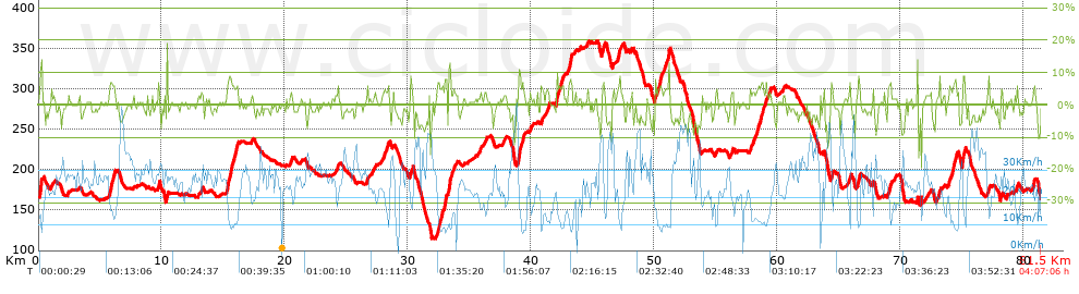
Distance in Km: 81.51
Climb in m: 1157
IBP: 75 BYC

Michel_Bobillier_??
283 published routes

Add to my Group or Club

 Height in m      Climb in %      Speed in Km/h      Speed < 2 Km/h

Climbs > 5%

Climbs >5% Climbs >10% Climbs >15% Climbs >20% Climbs >25%
 Steep slope of 187 m.   Average slope  Distances  Download as waypoint
1
 Km 0.077  9%  78 m
2
 Km 0.155  14%  109 m
 Steep slope of 469 m.  Average slope  Distances  Download as waypoint
3
 Km 5.759  6%  469 m
 Steep slope of 110 m.  Average slope  Distances  Download as waypoint
4
 Km 9.721  7%  110 m
 Steep slope of 790 m.  Average slope  Distances  Download as waypoint
5
 Km 15.342  7%  790 m
 Steep slope of 113 m.  Average slope  Distances  Download as waypoint
6
 Km 28.387  6%  113 m
 Steep slope of 174 m.  Average slope  Distances  Download as waypoint
7
 Km 30.244  8%  174 m
 Steep slope of 373 m.  Average slope  Distances  Download as waypoint
8
 Km 32.44  6%  373 m
 Steep slope of 488 m.  Average slope  Distances  Download as waypoint
9
 Km 32.953  5%  341 m
10
 Km 33.294  11%  147 m
 Steep slope of 430 m.  Average slope  Distances  Download as waypoint
11
 Km 38.995  8%  430 m
 Steep slope of 420 m.  Average slope  Distances  Download as waypoint
12
 Km 42.062  6%  420 m
 Steep slope of 247 m.  Average slope  Distances  Download as waypoint
13
 Km 43.13  7%  247 m
 Steep slope of 188 m.  Average slope  Distances  Download as waypoint
14
 Km 45.827  6%  188 m
 Steep slope of 140 m.  Average slope  Distances  Download as waypoint
15
 Km 47.141  8%  140 m
 Steep slope of 115 m.  Average slope  Distances  Download as waypoint
16
 Km 50.093  7%  115 m
 Steep slope of 310 m.  Average slope  Distances  Download as waypoint
17
 Km 50.33  7%  310 m
 Steep slope of 205 m.  Average slope  Distances  Download as waypoint
18
 Km 51.072  8%  205 m
 Steep slope of 199 m.  Average slope  Distances  Download as waypoint
19
 Km 58.621  5%  199 m
 Steep slope of 95 m.  Average slope  Distances  Download as waypoint
20
 Km 64.419  8%  95 m
 Steep slope of 178 m.  Average slope  Distances  Download as waypoint
21
 Km 66.589  7%  178 m
 Steep slope of 180 m.  Average slope  Distances  Download as waypoint
22
 Km 69.133  6%  180 m
 Steep slope of 114 m.  Average slope  Distances  Download as waypoint
23
 Km 74.004  6%  114 m
 Steep slope of 340 m.  Average slope  Distances  Download as waypoint
24
 Km 74.262  7%  340 m
 Steep slope of 260 m.  Average slope  Distances  Download as waypoint
25
 Km 75.061  9%  260 m
 Steep slope of 120 m.  Average slope  Distances  Download as waypoint
26
 Km 80.874  6%  120 m


Description of the route


Presence of ramps


 Climbs  Distance  % of the total  Speed  Your speed would be  Time  Your time would be
   15 - 30%  0.127  0.16  16.32  ?  0:00:28  ?
   10 - 15%  0.475  0.58  12.95  ?  0:02:12  ?
   5 - 10%  7.145  8.77  12.79  ?  0:33:31  ?
   1 - 5%  21.994  26.98  18.37  ?  1:11:50  ?
   Total*  29.74 Km  36.49 %  16.52 Km/h  ? Km/h    1:48:01 h  ? h  
 Flat
   1 - -1%  22.004 Km  27 %  25.28 Km/h  ? Km/h    0:52:13 h  ? h  
 Descents
   -1 - -5%  21.577  26.47  27.99  ?  0:46:15  ?
   -5 - -10%  7.32  8.98  30.47  ?  0:14:25  ?
   -10 - -15%  0.689  0.85  29.19  ?  0:01:25  ?
   -15 - -30%  0.174  0.21  20.94  ?  0:00:30  ?
   Total*  29.761 Km  36.51 %  28.53 Km/h  ? Km/h    1:02:35 h  ? h  
* The total has not necessarily coincide with the sum of the partials after correction of errors

How long would it take you?

How long would it take you to cover this route?
There are routes without a valid time information, but with your average stats you can assess the possible duration

Michel_Bobillier_?? to cover this route you've need a time of:   3:42:49 h 
If you sign in and have a minimum of two tracks of this same modality, you can know your time for this route, calculated from your stats..


¿Cuanto consumirá tu E-BIKE?

Entra tu E-IBP (formato n,nn)

E-IBP :   X 75 = 


 Detected activity type =  ()
 Penalization due to track conditions: 41 %   ( > 50 % = MTB, < 50 % = RDB)
 Reliability of the track: C   (1156/57/0/-/-/57)
 Correction level applied to the track: 0
DIFFICULTY OF THE ROUTE
IBP = 75 BYC
According to your statistics
 Your time in motion would be: ? h
Your average speed would be: ? Km/h
 

 Total Distance: 81.51 Km
 Analysed distance: 81.51 Km
 Linear distance: 0 Km

 Cumulated positive ramps: 1157.3 m  list of points info
 Cumulated negative ramps: 1160.9 m
 Maximum height: 359.9 m
 Minimum height: 115.1 m
 Climbing Ratio: 3.89 %
 Descent ratio: 3.9 %
 Cumulated postive ramps per Km: 14.2 m
 Cumulated negative ramps per Km: 14.24 m

 Total time: 4:07:06 h
 Time in movement: 3:42:49 h
 According to your statistics
 Your time in motion would be: ? h  
 Stopped time: 0:24:17 h
 Maximum slope filter: ~30 %
 Minimum separation analysed: ~30 m
 Number of points: 3621   (cad. 22.51 m)
 Significant waypoints: 1922   (cad. 42.41 m / 53.08 %)

 Changes in direction per Km: 7.85
 Changes in direction > 5º por Km: 3.36
 Cumulated straight stretches: 30.797 Km
 Straight stretches per Km: 377.83 m
 Penalized slope changes: 11
 Penalized slope changes per Km: 0.135

 Average speed in total: 19.79 Km/h
 Average speed while moving: 21.95 Km/h
 According to your statistics
 Your average speed would be: ? Km/h  
 Maximum sustained speed: 56.74 Km/h


Comments

You can be the first one in commenting this route

 
My comments
:
Add comment  (Registered users)
 
Notify me answers to my comment  Do not notify answers to my comment


Share this route with a friend

Your friend will receive a message with a link to this page:
will see your email and your user name if you do it as registered user.


Write here your name (optional)

E-mail address of your friend(s). You can include various addresses separated by commas

Text or comment (optional) maximum 255 characters long, 255 Available characters

As a non registered users you need to fill-in the captcha text.
  Change image
Type the image characters.
 
 Share with a friend


Visited history

Delete history

Marked routes for review later or compare

My favorites


  Notify anomaly in this route Share in Facebook