Picos de pueblo

MTB
MTB
Ref..: 837098
Published: 02/10/2019
Performed: 01/10/2019
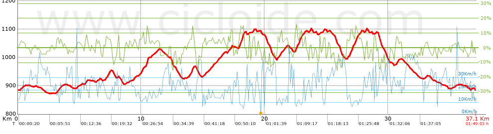
Distance in Km: 37.07
Climb in m: 897
IBP: 64 BYC

Near ...
Alpedrete, Collado Villalba, Molinos, Los, Negrales, Los, Valdencina
Edwin_Barrera
117 published routes

Add to my Group or Club

 Height in m      Climb in %      Speed in Km/h      Speed < 2 Km/h

Climbs > 5%

Climbs >5% Climbs >10% Climbs >15% Climbs >20% Climbs >25%
 Steep slope of 295 m.   Average slope  Distances  Download as waypoint
1
 Km 3.136  6%  295 m
 Steep slope of 153 m.  Average slope  Distances  Download as waypoint
2
 Km 5.493  7%  153 m
 Steep slope of 445 m.  Average slope  Distances  Download as waypoint
3
 Km 7.101  7%  445 m
 Steep slope of 165 m.  Average slope  Distances  Download as waypoint
4
 Km 9.366  5%  165 m
 Steep slope of 411 m.  Average slope  Distances  Download as waypoint
5
 Km 9.81  7%  411 m
 Steep slope of 250 m.  Average slope  Distances  Download as waypoint
6
 Km 10.36  8%  32 m
7
 Km 10.393  14%  184 m
8
 Km 10.577  8%  34 m
 Steep slope of 109 m.  Average slope  Distances  Download as waypoint
9
 Km 10.772  6%  109 m
 Steep slope of 408 m.  Average slope  Distances  Download as waypoint
10
 Km 13.852  6%  263 m
11
 Km 14.115  14%  113 m
12
 Km 14.228  7%  32 m
 Steep slope of 153 m.  Average slope  Distances  Download as waypoint
13
 Km 15.075  6%  153 m
 Steep slope of 153 m.  Average slope  Distances  Download as waypoint
14
 Km 15.717  6%  153 m
 Steep slope of 416 m.  Average slope  Distances  Download as waypoint
15
 Km 16.165  5%  416 m
 Steep slope of 115 m.  Average slope  Distances  Download as waypoint
16
 Km 16.971  6%  115 m
 Steep slope of 111 m.  Average slope  Distances  Download as waypoint
17
 Km 17.243  13%  111 m
 Steep slope of 438 m.  Average slope  Distances  Download as waypoint
18
 Km 17.867  8%  182 m
19
 Km 18.05  16%  182 m
20
 Km 18.232  14%  74 m
 Steep slope of 143 m.  Average slope  Distances  Download as waypoint
21
 Km 19.03  7%  143 m
 Steep slope of 147 m.  Average slope  Distances  Download as waypoint
22
 Km 20.972  6%  147 m
 Steep slope of 112 m.  Average slope  Distances  Download as waypoint
23
 Km 21.238  11%  112 m
 Steep slope of 170 m.  Average slope  Distances  Download as waypoint
24
 Km 21.617  6%  170 m
 Steep slope of 822 m.  Average slope  Distances  Download as waypoint
25
 Km 22.417  6%  32 m
26
 Km 22.449  14%  145 m
27
 Km 22.594  6%  175 m
28
 Km 22.769  12%  181 m
29
 Km 22.95  6%  146 m
30
 Km 23.097  5%  143 m
 Steep slope of 109 m.  Average slope  Distances  Download as waypoint
31
 Km 23.551  5%  109 m
 Steep slope of 207 m.  Average slope  Distances  Download as waypoint
32
 Km 24.673  7%  207 m
 Steep slope of 109 m.  Average slope  Distances  Download as waypoint
33
 Km 26.629  7%  109 m
 Steep slope of 671 m.  Average slope  Distances  Download as waypoint
34
 Km 26.839  7%  72 m
35
 Km 26.911  12%  183 m
36
 Km 27.094  8%  240 m
37
 Km 27.334  12%  139 m
38
 Km 27.473  12%  37 m
 Steep slope of 146 m.  Average slope  Distances  Download as waypoint
39
 Km 27.627  5%  146 m
 Steep slope of 169 m.  Average slope  Distances  Download as waypoint
40
 Km 28.075  7%  169 m
 Steep slope of 218 m.  Average slope  Distances  Download as waypoint
41
 Km 30.627  8%  218 m


Description of the route


Presence of ramps


 Climbs  Distance  % of the total  Speed  Your speed would be  Time  Your time would be
   15 - 30%  0.289  0.78  8.67  ?  0:02:00  ?
   10 - 15%  1.317  3.55  10.93  ?  0:07:14  ?
   5 - 10%  6.126  16.52  15.11  ?  0:24:19  ?
   1 - 5%  8.627  23.27  19.16  ?  0:27:01  ?
   Total*  16.359 Km  44.13 %  16.21 Km/h  ? Km/h    1:00:34 h  ? h  
 Flat
   1 - -1%  4.341 Km  11.71 %  23.29 Km/h  ? Km/h    0:11:11 h  ? h  
 Descents
   -1 - -5%  8.877  23.95  28.13  ?  0:18:56  ?
   -5 - -10%  5.415  14.61  29.67  ?  0:10:57  ?
   -10 - -15%  1.756  4.74  30.84  ?  0:03:25  ?
   -15 - -30%  0.324  0.88  33.37  ?  0:00:35  ?
   Total*  16.373 Km  44.16 %  28.99 Km/h  ? Km/h    0:33:53 h  ? h  
* The total has not necessarily coincide with the sum of the partials after correction of errors

How long would it take you?

How long would it take you to cover this route?
There are routes without a valid time information, but with your average stats you can assess the possible duration

Edwin_Barrera to cover this route you've need a time of:   1:45:38 h 
If you sign in and have a minimum of two tracks of this same modality, you can know your time for this route, calculated from your stats..


¿Cuanto consumirá tu E-BIKE?

Entra tu E-IBP (formato n,nn)

E-IBP :   X 64 = 


 Detected activity type =  ()
 Penalization due to track conditions: 72 %   ( > 50 % = MTB, < 50 % = RDB)
 Reliability of the track: B   (897/64/0/-/-/64)
 Correction level applied to the track: 0
DIFFICULTY OF THE ROUTE
IBP = 64 BYC
According to your statistics
 Your time in motion would be: ? h
Your average speed would be: ? Km/h
 

 Total Distance: 37.07 Km
 Analysed distance: 37.07 Km
 Linear distance: 0.07 Km

 Cumulated positive ramps: 897.4 m  list of points info
 Cumulated negative ramps: 896.1 m
 Maximum height: 1102 m
 Minimum height: 872.3 m
 Climbing Ratio: 5.49 %
 Descent ratio: 5.47 %
 Cumulated postive ramps per Km: 24.21 m
 Cumulated negative ramps per Km: 24.17 m

 Total time: 1:49:03 h
 Time in movement: 1:45:38 h
 According to your statistics
 Your time in motion would be: ? h  
 Stopped time: 0:03:25 h
 Maximum slope filter: ~30 %
 Minimum separation analysed: ~30 m
 Number of points: 2752   (cad. 13.47 m)
 Significant waypoints: 1016   (cad. 36.49 m / 36.92 %)

 Changes in direction per Km: 12.22
 Changes in direction > 5º por Km: 7.2
 Cumulated straight stretches: 7.373 Km
 Straight stretches per Km: 198.89 m
 Penalized slope changes: 9
 Penalized slope changes per Km: 0.243

 Average speed in total: 20.4 Km/h
 Average speed while moving: 21.06 Km/h
 According to your statistics
 Your average speed would be: ? Km/h  
 Maximum sustained speed: 51.9 Km/h


Comments

You can be the first one in commenting this route

 
My comments
:
Add comment  (Registered users)
 
Notify me answers to my comment  Do not notify answers to my comment


Share this route with a friend

Your friend will receive a message with a link to this page:
will see your email and your user name if you do it as registered user.


Write here your name (optional)

E-mail address of your friend(s). You can include various addresses separated by commas

Text or comment (optional) maximum 255 characters long, 255 Available characters

As a non registered users you need to fill-in the captcha text.
  Change image
Type the image characters.
 
 Share with a friend


Visited history

Delete history

Marked routes for review later or compare

My favorites


  Notify anomaly in this route Share in Facebook