Azuébar

Road
Road
Ref..: 836951
Published: 02/10/2019
Performed: 02/10/2019
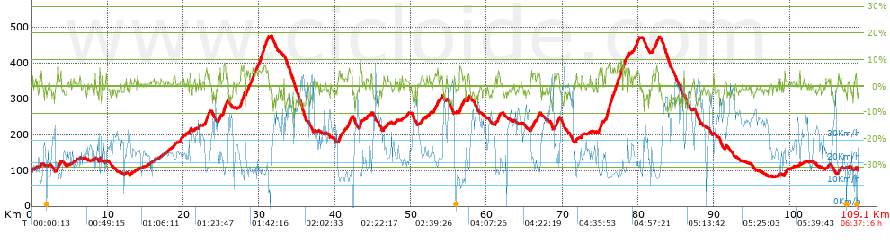
Distance in Km: 109.15
Climb in m: 1458
IBP: 99 BYC

Near ...
Aeropuerto De Manises (Valencia), Cañada, La, Collado (Partida), Presa, La, Riba-Roja De Turia, Vallesa, La (Urbanizacion)
asegovia
Author: asegovia
375 published routes

Add to my Group or Club

 Height in m      Climb in %      Speed in Km/h      Speed < 2 Km/h

Climbs > 5%

Climbs >5% Climbs >10% Climbs >15% Climbs >20% Climbs >25%
 Steep slope of 141 m.   Average slope  Distances  Download as waypoint
1
 Km 3.409  6%  141 m
 Steep slope of 111 m.  Average slope  Distances  Download as waypoint
2
 Km 8.914  9%  111 m
 Steep slope of 145 m.  Average slope  Distances  Download as waypoint
3
 Km 20.805  6%  145 m
 Steep slope of 95 m.  Average slope  Distances  Download as waypoint
4
 Km 22.096  6%  95 m
 Steep slope of 279 m.  Average slope  Distances  Download as waypoint
5
 Km 22.874  7%  279 m
 Steep slope of 100 m.  Average slope  Distances  Download as waypoint
6
 Km 23.254  6%  100 m
 Steep slope of 107 m.  Average slope  Distances  Download as waypoint
7
 Km 24.804  7%  107 m
 Steep slope of 276 m.  Average slope  Distances  Download as waypoint
8
 Km 25.267  8%  276 m
 Steep slope of 436 m.  Average slope  Distances  Download as waypoint
9
 Km 27.591  7%  436 m
 Steep slope of 307 m.  Average slope  Distances  Download as waypoint
10
 Km 28.261  6%  307 m
 Steep slope of 394 m.  Average slope  Distances  Download as waypoint
11
 Km 29.001  6%  394 m
 Steep slope of 100 m.  Average slope  Distances  Download as waypoint
12
 Km 29.539  5%  100 m
 Steep slope of 565 m.  Average slope  Distances  Download as waypoint
13
 Km 29.949  6%  565 m
 Steep slope of 384 m.  Average slope  Distances  Download as waypoint
14
 Km 30.629  6%  384 m
 Steep slope of 138 m.  Average slope  Distances  Download as waypoint
15
 Km 40.496  6%  138 m
 Steep slope of 179 m.  Average slope  Distances  Download as waypoint
16
 Km 41.792  6%  179 m
 Steep slope of 221 m.  Average slope  Distances  Download as waypoint
17
 Km 43.275  7%  221 m
 Steep slope of 106 m.  Average slope  Distances  Download as waypoint
18
 Km 53.455  7%  106 m
 Steep slope of 242 m.  Average slope  Distances  Download as waypoint
19
 Km 56.429  6%  242 m
 Steep slope of 107 m.  Average slope  Distances  Download as waypoint
20
 Km 56.851  6%  107 m
 Steep slope of 163 m.  Average slope  Distances  Download as waypoint
21
 Km 57.565  6%  163 m
 Steep slope of 198 m.  Average slope  Distances  Download as waypoint
22
 Km 61.499  7%  198 m
 Steep slope of 109 m.  Average slope  Distances  Download as waypoint
23
 Km 66.699  5%  109 m
 Steep slope of 147 m.  Average slope  Distances  Download as waypoint
24
 Km 69.171  5%  147 m
 Steep slope of 179 m.  Average slope  Distances  Download as waypoint
25
 Km 74.773  6%  179 m
 Steep slope of 119 m.  Average slope  Distances  Download as waypoint
26
 Km 75.064  5%  119 m
 Steep slope of 992 m.  Average slope  Distances  Download as waypoint
27
 Km 75.72  7%  992 m
 Steep slope of 566 m.  Average slope  Distances  Download as waypoint
28
 Km 76.835  7%  566 m
 Steep slope of 313 m.  Average slope  Distances  Download as waypoint
29
 Km 77.502  7%  313 m
 Steep slope of 158 m.  Average slope  Distances  Download as waypoint
30
 Km 77.997  7%  158 m
 Steep slope of 212 m.  Average slope  Distances  Download as waypoint
31
 Km 78.276  6%  212 m
 Steep slope of 142 m.  Average slope  Distances  Download as waypoint
32
 Km 78.736  6%  142 m
 Steep slope of 329 m.  Average slope  Distances  Download as waypoint
33
 Km 79.689  5%  329 m
 Steep slope of 145 m.  Average slope  Distances  Download as waypoint
34
 Km 82.276  5%  145 m
 Steep slope of 109 m.  Average slope  Distances  Download as waypoint
35
 Km 82.531  6%  109 m


Description of the route


Presence of ramps


 Climbs  Distance  % of the total  Speed  Your speed would be  Time  Your time would be
   15 - 30%  0  0  0  ?  0:00:00  ?
   10 - 15%  0.115  0.11  15.95  ?  0:00:26  ?
   5 - 10%  10.189  9.34  17.12  ?  0:35:43  ?
   1 - 5%  30.099  27.58  21.08  ?  1:25:41  ?
   Total*  40.404 Km  37.02 %  19.9 Km/h  ? Km/h    2:01:50 h  ? h  
 Flat
   1 - -1%  26.947 Km  24.69 %  26.45 Km/h  ? Km/h    1:01:08 h  ? h  
 Descents
   -1 - -5%  32.145  29.45  33.64  ?  0:57:20  ?
   -5 - -10%  9.482  8.69  39.24  ?  0:14:30  ?
   -10 - -15%  0.137  0.13  30.81  ?  0:00:16  ?
   -15 - -30%  0.033  0.03  29.77  ?  0:00:04  ?
   Total*  41.797 Km  38.29 %  34.75 Km/h  ? Km/h    1:12:10 h  ? h  
* The total has not necessarily coincide with the sum of the partials after correction of errors

How long would it take you?

How long would it take you to cover this route?
There are routes without a valid time information, but with your average stats you can assess the possible duration

asegovia to cover this route you've need a time of:   4:15:08 h 
If you sign in and have a minimum of two tracks of this same modality, you can know your time for this route, calculated from your stats..


¿Cuanto consumirá tu E-BIKE?

Entra tu E-IBP (formato n,nn)

E-IBP :   X 99 = 


 Detected activity type =  ()
 Penalization due to track conditions: 38 %   ( > 50 % = MTB, < 50 % = RDB)
 Reliability of the track: B   (1456/70/0/-/-/70)
 Correction level applied to the track: 0
DIFFICULTY OF THE ROUTE
IBP = 99 BYC
According to your statistics
 Your time in motion would be: ? h
Your average speed would be: ? Km/h
 

 Total Distance: 109.15 Km
 Analysed distance: 109.15 Km
 Linear distance: 0.37 Km

 Cumulated positive ramps: 1457.8 m  list of points info
 Cumulated negative ramps: 1459.4 m
 Maximum height: 475 m
 Minimum height: 81.6 m
 Climbing Ratio: 3.61 %
 Descent ratio: 3.49 %
 Cumulated postive ramps per Km: 13.36 m
 Cumulated negative ramps per Km: 13.37 m

 Total time: 6:37:16 h
 Time in movement: 4:15:08 h
 According to your statistics
 Your time in motion would be: ? h  
 Stopped time: 2:22:08 h
 Maximum slope filter: ~30 %
 Minimum separation analysed: ~30 m
 Number of points: 8082   (cad. 13.51 m)
 Significant waypoints: 3027   (cad. 36.06 m / 37.45 %)

 Changes in direction per Km: 8.8
 Changes in direction > 5º por Km: 4.55
 Cumulated straight stretches: 45.179 Km
 Straight stretches per Km: 413.92 m
 Penalized slope changes: 13
 Penalized slope changes per Km: 0.119

 Average speed in total: 16.48 Km/h
 Average speed while moving: 25.67 Km/h
 According to your statistics
 Your average speed would be: ? Km/h  
 Maximum sustained speed: 60.78 Km/h


Comments

You can be the first one in commenting this route

 
My comments
:
Add comment  (Registered users)
 
Notify me answers to my comment  Do not notify answers to my comment


Share this route with a friend

Your friend will receive a message with a link to this page:
will see your email and your user name if you do it as registered user.


Write here your name (optional)

E-mail address of your friend(s). You can include various addresses separated by commas

Text or comment (optional) maximum 255 characters long, 255 Available characters

As a non registered users you need to fill-in the captcha text.
  Change image
Type the image characters.
 
 Share with a friend


Visited history

Delete history

Marked routes for review later or compare

My favorites


  Notify anomaly in this route Share in Facebook