Giro mattutino

Road
Road
Ref..: 836898
Published: 02/10/2019
Performed: 01/10/2019
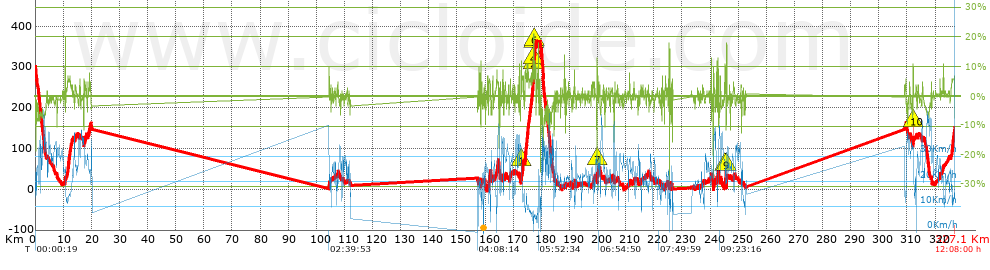
Distance in Km: 327.11
Climb in m: 1862
IBP: 288 BYC


 Height in m      Climb in %      Speed in Km/h      Speed < 2 Km/h

Climbs > 5%

Climbs >5% Climbs >10% Climbs >15% Climbs >20% Climbs >25%
 Steep slope of 123 m.   Average slope  Distances  Download as waypoint
1
 Km 10.673  15%  123 m
 Steep slope of 679 m.  Average slope  Distances  Download as waypoint
2
 Km 11.611  6%  679 m
 Steep slope of 150 m.  Average slope  Distances  Download as waypoint
3
 Km 17.401  6%  150 m
 Steep slope of 112 m.  Average slope  Distances  Download as waypoint
4
 Km 19.289  7%  112 m
 Steep slope of 104 m.  Average slope  Distances  Download as waypoint
5
 Km 157.758  9%  104 m
 Steep slope of 148 m.  Average slope  Distances  Download as waypoint
6
 Km 158.402  8%  148 m
 Steep slope of 107 m.  Average slope  Distances  Download as waypoint
7
 Km 158.862  7%  107 m
 Steep slope of 414 m.  Average slope  Distances  Download as waypoint
8
 Km 161.476  5%  414 m
 Steep slope of 363 m.  Average slope  Distances  Download as waypoint
9
 Km 164.105  5%  363 m
 Steep slope of 102 m.  Average slope  Distances  Download as waypoint
10
 Km 166.294  7%  102 m
 Steep slope of 119 m.  Average slope  Distances  Download as waypoint
11
 Km 168.906  7%  119 m
 Steep slope of 103 m.  Average slope  Distances  Download as waypoint
12
 Km 172.081  9%  103 m
 Steep slope of 186 m.  Average slope  Distances  Download as waypoint
13
 Km 172.721  7%  74 m
14
 Km 172.795  11%  112 m
 Steep slope of 423 m.  Average slope  Distances  Download as waypoint
15
 Km 173.189  7%  423 m
 Steep slope of 754 m.  Average slope  Distances  Download as waypoint
16
 Km 174.159  8%  754 m
 Steep slope of 377 m.  Average slope  Distances  Download as waypoint
17
 Km 175.085  8%  377 m
 Steep slope of 133 m.  Average slope  Distances  Download as waypoint
18
 Km 175.635  7%  133 m
 Steep slope of 136 m.  Average slope  Distances  Download as waypoint
19
 Km 175.866  7%  136 m
 Steep slope of 171 m.  Average slope  Distances  Download as waypoint
20
 Km 176.1  5%  171 m
 Steep slope of 105 m.  Average slope  Distances  Download as waypoint
21
 Km 176.453  9%  105 m
 Steep slope of 1338 m.  Average slope  Distances  Download as waypoint
22
 Km 176.655  7%  435 m
23
 Km 177.09  13%  33 m
24
 Km 177.123  19%  65 m
25
 Km 177.189  20%  131 m
26
 Km 177.32  21%  33 m
27
 Km 177.353  5%  98 m
28
 Km 177.451  13%  101 m
29
 Km 177.552  8%  442 m
 Steep slope of 136 m.  Average slope  Distances  Download as waypoint
30
 Km 188.568  7%  136 m
 Steep slope of 98 m.  Average slope  Distances  Download as waypoint
31
 Km 191.738  6%  98 m
 Steep slope of 96 m.  Average slope  Distances  Download as waypoint
32
 Km 199.839  22%  96 m
 Steep slope of 129 m.  Average slope  Distances  Download as waypoint
33
 Km 222.959  6%  129 m
 Steep slope of 110 m.  Average slope  Distances  Download as waypoint
34
 Km 225.413  14%  110 m
 Steep slope of 124 m.  Average slope  Distances  Download as waypoint
35
 Km 241.234  10%  124 m
 Steep slope of 121 m.  Average slope  Distances  Download as waypoint
36
 Km 242.278  11%  121 m
 Steep slope of 202 m.  Average slope  Distances  Download as waypoint
37
 Km 242.752  8%  202 m
 Steep slope of 216 m.  Average slope  Distances  Download as waypoint
38
 Km 243.548  7%  216 m
 Steep slope of 267 m.  Average slope  Distances  Download as waypoint
39
 Km 245.239  11%  195 m
40
 Km 245.434  8%  72 m
 Steep slope of 213 m.  Average slope  Distances  Download as waypoint
41
 Km 245.791  17%  175 m
42
 Km 245.966  7%  38 m
 Steep slope of 201 m.  Average slope  Distances  Download as waypoint
43
 Km 312.118  11%  108 m
44
 Km 312.227  9%  93 m
 Steep slope of 134 m.  Average slope  Distances  Download as waypoint
45
 Km 321.668  7%  134 m
 Steep slope of 1051 m.  Average slope  Distances  Download as waypoint
46
 Km 325.86  6%  1051 m


Description of the route


Presence of ramps


 Climbs  Distance  % of the total  Speed  Your speed would be  Time  Your time would be
   15 - 30%  0.975  0.3  13.87  ?  0:04:13  ?
   10 - 15%  1.507  0.46  17.73  ?  0:05:06  ?
   5 - 10%  9.629  2.94  14.04  ?  0:41:08  ?
   1 - 5%  34.117  10.43  20.51  ?  1:39:47  ?
   Total*  46.227 Km  14.13 %  18.46 Km/h  ? Km/h    2:30:14 h  ? h  
 Flat
   1 - -1%  232.518 Km  71.08 %  32.64 Km/h  ? Km/h    7:07:29 h  ? h  
 Descents
   -1 - -5%  34.548  10.56  22.02  ?  1:34:07  ?
   -5 - -10%  11.213  3.43  25.88  ?  0:26:00  ?
   -10 - -15%  1.704  0.52  17.47  ?  0:05:51  ?
   -15 - -30%  0.896  0.27  25.39  ?  0:02:07  ?
   Total*  48.361 Km  14.78 %  22.65 Km/h  ? Km/h    2:08:05 h  ? h  
* The total has not necessarily coincide with the sum of the partials after correction of errors

How long would it take you?

How long would it take you to cover this route?
There are routes without a valid time information, but with your average stats you can assess the possible duration

Massimiliano_Figliuzzi to cover this route you've need a time of:   11:45:48 h 
If you sign in and have a minimum of two tracks of this same modality, you can know your time for this route, calculated from your stats..


¿Cuanto consumirá tu E-BIKE?

Entra tu E-IBP (formato n,nn)

E-IBP :   X 288 = 


 Detected activity type =  ()
 Penalization due to track conditions: 22 %   ( > 50 % = MTB, < 50 % = RDB)
 Reliability of the track: C   (1881/56/0/-/-/56)
 Correction level applied to the track: 0
DIFFICULTY OF THE ROUTE
IBP = 288 BYC
According to your statistics
 Your time in motion would be: ? h
Your average speed would be: ? Km/h
 

 Total Distance: 327.11 Km
 Analysed distance: 327.11 Km
 Linear distance: 0.59 Km

 Cumulated positive ramps: 1861.88 m  list of points info
 Cumulated negative ramps: 2026.32 m
 Maximum height: 362.7 m
 Minimum height: -4.3 m
 Climbing Ratio: 4.03 %
 Descent ratio: 4.19 %
 Cumulated postive ramps per Km: 5.69 m
 Cumulated negative ramps per Km: 6.19 m

 Total time: 12:08:00 h
 Time in movement: 11:45:48 h
 According to your statistics
 Your time in motion would be: ? h  
 Stopped time: 0:22:12 h
 Maximum slope filter: ~30 %
 Minimum separation analysed: ~30 m
 Number of points: 10003   (cad. 32.7 m)
 Significant waypoints: 3802   (cad. 86.04 m / 38.01 %)

 Changes in direction per Km: 4.48
 Changes in direction > 5º por Km: 1.84
 Cumulated straight stretches: 57.491 Km
 Straight stretches per Km: 175.75 m
 Penalized slope changes: 14
 Penalized slope changes per Km: 0.043

 Average speed in total: 26.96 Km/h
 Average speed while moving: 27.81 Km/h
 According to your statistics
 Your average speed would be: ? Km/h  
 Maximum sustained speed: 51.06 Km/h


Comments

You can be the first one in commenting this route

 
My comments
:
Add comment  (Registered users)
 
Notify me answers to my comment  Do not notify answers to my comment


Share this route with a friend

Your friend will receive a message with a link to this page:
will see your email and your user name if you do it as registered user.


Write here your name (optional)

E-mail address of your friend(s). You can include various addresses separated by commas

Text or comment (optional) maximum 255 characters long, 255 Available characters

As a non registered users you need to fill-in the captcha text.
  Change image
Type the image characters.
 
 Share with a friend


Visited history

Delete history

Marked routes for review later or compare

My favorites


  Notify anomaly in this route Share in Facebook