Castelldefels Tibidabo

Road
Road
Ref..: 834853
Published: 29/09/2019
Performed: 28/09/2019
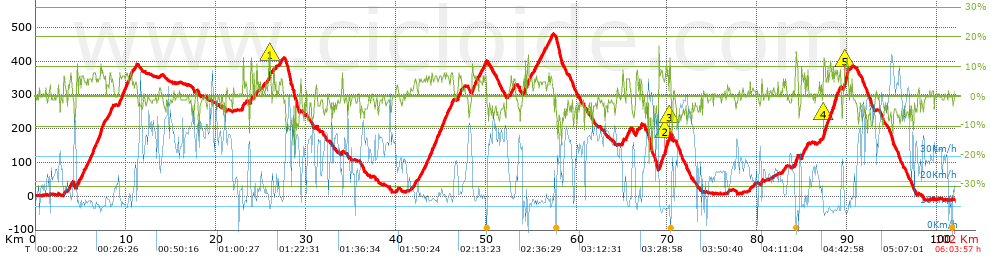
Distance in Km: 102.04
Climb in m: 1914
IBP: 127 BYC

Near ...
Bera (Urbanitzacio), Can Valls-To (Urbanitzacio), Casalot, El (Urbanitzacio), Castelldefels, Clara Mar (Urbanitzacio), Costa Zefir (Urbanitzacio)

 Height in m      Climb in %      Speed in Km/h      Speed < 2 Km/h

Climbs > 5%

Climbs >5% Climbs >10% Climbs >15% Climbs >20% Climbs >25%
 Steep slope of 145 m.   Average slope  Distances  Download as waypoint
1
 Km 3.135  6%  145 m
 Steep slope of 223 m.  Average slope  Distances  Download as waypoint
2
 Km 3.846  6%  223 m
 Steep slope of 277 m.  Average slope  Distances  Download as waypoint
3
 Km 4.598  7%  277 m
 Steep slope of 470 m.  Average slope  Distances  Download as waypoint
4
 Km 5.09  6%  470 m
 Steep slope of 449 m.  Average slope  Distances  Download as waypoint
5
 Km 5.685  6%  449 m
 Steep slope of 1435 m.  Average slope  Distances  Download as waypoint
6
 Km 6.299  7%  1435 m
 Steep slope of 477 m.  Average slope  Distances  Download as waypoint
7
 Km 8.086  6%  477 m
 Steep slope of 1371 m.  Average slope  Distances  Download as waypoint
8
 Km 9.276  7%  1371 m
 Steep slope of 115 m.  Average slope  Distances  Download as waypoint
9
 Km 23.013  11%  115 m
 Steep slope of 181 m.  Average slope  Distances  Download as waypoint
10
 Km 23.816  9%  181 m
 Steep slope of 109 m.  Average slope  Distances  Download as waypoint
11
 Km 24.224  9%  109 m
 Steep slope of 120 m.  Average slope  Distances  Download as waypoint
12
 Km 25.926  12%  120 m
 Steep slope of 156 m.  Average slope  Distances  Download as waypoint
13
 Km 42.025  6%  156 m
 Steep slope of 165 m.  Average slope  Distances  Download as waypoint
14
 Km 42.505  6%  165 m
 Steep slope of 477 m.  Average slope  Distances  Download as waypoint
15
 Km 42.82  5%  477 m
 Steep slope of 324 m.  Average slope  Distances  Download as waypoint
16
 Km 43.407  6%  324 m
 Steep slope of 1330 m.  Average slope  Distances  Download as waypoint
17
 Km 43.85  6%  1330 m
 Steep slope of 586 m.  Average slope  Distances  Download as waypoint
18
 Km 45.295  7%  586 m
 Steep slope of 270 m.  Average slope  Distances  Download as waypoint
19
 Km 46.001  6%  270 m
 Steep slope of 421 m.  Average slope  Distances  Download as waypoint
20
 Km 46.868  7%  421 m
 Steep slope of 659 m.  Average slope  Distances  Download as waypoint
21
 Km 48.435  7%  659 m
 Steep slope of 203 m.  Average slope  Distances  Download as waypoint
22
 Km 49.237  6%  203 m
 Steep slope of 247 m.  Average slope  Distances  Download as waypoint
23
 Km 49.645  6%  247 m
 Steep slope of 213 m.  Average slope  Distances  Download as waypoint
24
 Km 52.677  6%  213 m
 Steep slope of 153 m.  Average slope  Distances  Download as waypoint
25
 Km 53.017  6%  153 m
 Steep slope of 234 m.  Average slope  Distances  Download as waypoint
26
 Km 54.107  6%  234 m
 Steep slope of 515 m.  Average slope  Distances  Download as waypoint
27
 Km 54.483  7%  515 m
 Steep slope of 112 m.  Average slope  Distances  Download as waypoint
28
 Km 55.295  7%  112 m
 Steep slope of 189 m.  Average slope  Distances  Download as waypoint
29
 Km 55.725  6%  189 m
 Steep slope of 462 m.  Average slope  Distances  Download as waypoint
30
 Km 56.057  6%  462 m
 Steep slope of 183 m.  Average slope  Distances  Download as waypoint
31
 Km 56.923  6%  183 m
 Steep slope of 108 m.  Average slope  Distances  Download as waypoint
32
 Km 57.213  6%  108 m
 Steep slope of 142 m.  Average slope  Distances  Download as waypoint
33
 Km 65.099  8%  142 m
 Steep slope of 433 m.  Average slope  Distances  Download as waypoint
34
 Km 65.508  7%  433 m
 Steep slope of 152 m.  Average slope  Distances  Download as waypoint
35
 Km 66.611  9%  152 m
 Steep slope of 147 m.  Average slope  Distances  Download as waypoint
36
 Km 67.098  8%  147 m
 Steep slope of 1213 m.  Average slope  Distances  Download as waypoint
37
 Km 69.143  8%  649 m
38
 Km 69.793  10%  151 m
39
 Km 69.943  7%  340 m
40
 Km 70.284  12%  73 m
 Steep slope of 148 m.  Average slope  Distances  Download as waypoint
41
 Km 80.455  8%  148 m
 Steep slope of 190 m.  Average slope  Distances  Download as waypoint
42
 Km 82.943  5%  190 m
 Steep slope of 345 m.  Average slope  Distances  Download as waypoint
43
 Km 84.206  9%  345 m
 Steep slope of 288 m.  Average slope  Distances  Download as waypoint
44
 Km 84.932  7%  288 m
 Steep slope of 203 m.  Average slope  Distances  Download as waypoint
45
 Km 85.441  6%  203 m
 Steep slope of 111 m.  Average slope  Distances  Download as waypoint
46
 Km 86.937  6%  111 m
 Steep slope of 1109 m.  Average slope  Distances  Download as waypoint
47
 Km 87.348  7%  43 m
48
 Km 87.391  11%  233 m
49
 Km 87.624  7%  833 m
 Steep slope of 638 m.  Average slope  Distances  Download as waypoint
50
 Km 88.577  8%  638 m
 Steep slope of 556 m.  Average slope  Distances  Download as waypoint
51
 Km 89.591  8%  193 m
52
 Km 89.784  12%  363 m


Description of the route


Presence of ramps


 Climbs  Distance  % of the total  Speed  Your speed would be  Time  Your time would be
   15 - 30%  0.076  0.07  14.41  ?  0:00:19  ?
   10 - 15%  2.129  2.09  10.54  ?  0:12:07  ?
   5 - 10%  17.096  16.75  13.01  ?  1:18:51  ?
   1 - 5%  17.943  17.58  16.97  ?  1:03:26  ?
   Total*  37.245 Km  36.5 %  14.44 Km/h  ? Km/h    2:34:43 h  ? h  
 Flat
   1 - -1%  24.566 Km  24.08 %  23.67 Km/h  ? Km/h    1:02:16 h  ? h  
 Descents
   -1 - -5%  25.401  24.89  32.85  ?  0:46:24  ?
   -5 - -10%  11.998  11.76  35.91  ?  0:20:03  ?
   -10 - -15%  2.165  2.12  37.11  ?  0:03:30  ?
   -15 - -30%  0.664  0.65  35.16  ?  0:01:08  ?
   Total*  40.229 Km  39.42 %  33.96 Km/h  ? Km/h    1:11:05 h  ? h  
* The total has not necessarily coincide with the sum of the partials after correction of errors

How long would it take you?

How long would it take you to cover this route?
There are routes without a valid time information, but with your average stats you can assess the possible duration

Pau_"Polvorilla" to cover this route you've need a time of:   4:48:04 h 
If you sign in and have a minimum of two tracks of this same modality, you can know your time for this route, calculated from your stats..


¿Cuanto consumirá tu E-BIKE?

Entra tu E-IBP (formato n,nn)

E-IBP :   X 127 = 


 Detected activity type =  ()
 Penalization due to track conditions: 49 %   ( > 50 % = MTB, < 50 % = RDB)
 Reliability of the track: A   (1914/78/0/-/-/78)
 Correction level applied to the track: 0
DIFFICULTY OF THE ROUTE
IBP = 127 BYC
According to your statistics
 Your time in motion would be: ? h
Your average speed would be: ? Km/h
 

 Total Distance: 102.04 Km
 Analysed distance: 102.04 Km
 Linear distance: 0.03 Km

 Cumulated positive ramps: 1914 m  list of points info
 Cumulated negative ramps: 1908.6 m
 Maximum height: 480.4 m
 Minimum height: -11.6 m
 Climbing Ratio: 5.14 %
 Descent ratio: 4.74 %
 Cumulated postive ramps per Km: 18.76 m
 Cumulated negative ramps per Km: 18.7 m

 Total time: 6:03:57 h
 Time in movement: 4:48:04 h
 According to your statistics
 Your time in motion would be: ? h  
 Stopped time: 1:15:53 h
 Maximum slope filter: ~30 %
 Minimum separation analysed: ~30 m
 Number of points: 4070   (cad. 25.07 m)
 Significant waypoints: 2283   (cad. 44.7 m / 56.09 %)

 Changes in direction per Km: 8.27
 Changes in direction > 5º por Km: 5.78
 Cumulated straight stretches: 25.657 Km
 Straight stretches per Km: 251.44 m
 Penalized slope changes: 18
 Penalized slope changes per Km: 0.176

 Average speed in total: 16.82 Km/h
 Average speed while moving: 21.25 Km/h
 According to your statistics
 Your average speed would be: ? Km/h  
 Maximum sustained speed: 72.31 Km/h


Comments

You can be the first one in commenting this route

 
My comments
:
Add comment  (Registered users)
 
Notify me answers to my comment  Do not notify answers to my comment


Share this route with a friend

Your friend will receive a message with a link to this page:
will see your email and your user name if you do it as registered user.


Write here your name (optional)

E-mail address of your friend(s). You can include various addresses separated by commas

Text or comment (optional) maximum 255 characters long, 255 Available characters

As a non registered users you need to fill-in the captcha text.
  Change image
Type the image characters.
 
 Share with a friend


Visited history

Delete history

Marked routes for review later or compare

My favorites


  Notify anomaly in this route Share in Facebook