Uffff estoy peor de lo que pensaba. Cuanto me queda de sufrimiento __

MTB
MTB
Ref..: 834815
Published: 29/09/2019
Performed: 29/09/2019
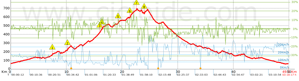
Distance in Km: 49.9
Climb in m: 1093
IBP: 82 BYC

Near ...
Boqueres, Monteros, Los (San Vicente Del Raspeig), Sant Vicent Del Raspeig
David Quereda
90 published routes

Add to my Group or Club

 Height in m      Climb in %      Speed in Km/h      Speed < 2 Km/h

Climbs > 5%

Climbs >5% Climbs >10% Climbs >15% Climbs >20% Climbs >25%
 Steep slope of 223 m.   Average slope  Distances  Download as waypoint
1
 Km 7.28  6%  148 m
2
 Km 7.428  15%  75 m
 Steep slope of 171 m.  Average slope  Distances  Download as waypoint
3
 Km 8.178  7%  171 m
 Steep slope of 104 m.  Average slope  Distances  Download as waypoint
4
 Km 9.309  5%  104 m
 Steep slope of 282 m.  Average slope  Distances  Download as waypoint
5
 Km 9.626  7%  282 m
 Steep slope of 337 m.  Average slope  Distances  Download as waypoint
6
 Km 10.083  6%  70 m
7
 Km 10.152  11%  135 m
8
 Km 10.287  9%  132 m
 Steep slope of 175 m.  Average slope  Distances  Download as waypoint
9
 Km 10.52  8%  69 m
10
 Km 10.589  5%  106 m
 Steep slope of 140 m.  Average slope  Distances  Download as waypoint
11
 Km 11.733  8%  140 m
 Steep slope of 235 m.  Average slope  Distances  Download as waypoint
12
 Km 12.111  6%  235 m
 Steep slope of 139 m.  Average slope  Distances  Download as waypoint
13
 Km 12.985  7%  139 m
 Steep slope of 402 m.  Average slope  Distances  Download as waypoint
14
 Km 13.362  6%  402 m
 Steep slope of 139 m.  Average slope  Distances  Download as waypoint
15
 Km 14.248  6%  139 m
 Steep slope of 175 m.  Average slope  Distances  Download as waypoint
16
 Km 14.59  6%  175 m
 Steep slope of 136 m.  Average slope  Distances  Download as waypoint
17
 Km 14.863  9%  136 m
 Steep slope of 1372 m.  Average slope  Distances  Download as waypoint
18
 Km 15.3  7%  672 m
19
 Km 15.972  10%  234 m
20
 Km 16.206  9%  200 m
21
 Km 16.406  13%  201 m
22
 Km 16.607  7%  65 m
 Steep slope of 135 m.  Average slope  Distances  Download as waypoint
23
 Km 17.053  7%  135 m
 Steep slope of 377 m.  Average slope  Distances  Download as waypoint
24
 Km 18.2  7%  377 m
 Steep slope of 132 m.  Average slope  Distances  Download as waypoint
25
 Km 18.676  5%  132 m
 Steep slope of 392 m.  Average slope  Distances  Download as waypoint
26
 Km 19.058  6%  229 m
27
 Km 19.287  11%  163 m
 Steep slope of 339 m.  Average slope  Distances  Download as waypoint
28
 Km 20.622  8%  339 m
 Steep slope of 393 m.  Average slope  Distances  Download as waypoint
29
 Km 21.345  8%  34 m
30
 Km 21.379  13%  327 m
31
 Km 21.706  8%  32 m
 Steep slope of 233 m.  Average slope  Distances  Download as waypoint
32
 Km 21.84  8%  233 m
 Steep slope of 203 m.  Average slope  Distances  Download as waypoint
33
 Km 22.449  8%  69 m
34
 Km 22.518  12%  100 m
35
 Km 22.619  12%  34 m
 Steep slope of 172 m.  Average slope  Distances  Download as waypoint
36
 Km 23.995  16%  139 m
37
 Km 24.134  8%  33 m
 Steep slope of 267 m.  Average slope  Distances  Download as waypoint
38
 Km 24.307  9%  267 m
 Steep slope of 106 m.  Average slope  Distances  Download as waypoint
39
 Km 26.615  6%  106 m
 Steep slope of 97 m.  Average slope  Distances  Download as waypoint
40
 Km 26.971  6%  97 m
 Steep slope of 113 m.  Average slope  Distances  Download as waypoint
41
 Km 37.337  8%  113 m
 Steep slope of 176 m.  Average slope  Distances  Download as waypoint
42
 Km 37.663  8%  176 m
 Steep slope of 135 m.  Average slope  Distances  Download as waypoint
43
 Km 41.264  6%  135 m


Description of the route


Presence of ramps


 Climbs  Distance  % of the total  Speed  Your speed would be  Time  Your time would be
   15 - 30%  0.409  0.82  6.97  ?  0:03:31  ?
   10 - 15%  1.947  3.9  8.01  ?  0:14:35  ?
   5 - 10%  6.623  13.27  10.14  ?  0:39:12  ?
   1 - 5%  12.589  25.23  15.99  ?  0:47:15  ?
   Total*  21.568 Km  43.22 %  12.38 Km/h  ? Km/h    1:44:33 h  ? h  
 Flat
   1 - -1%  6.994 Km  14.02 %  20.22 Km/h  ? Km/h    0:20:45 h  ? h  
 Descents
   -1 - -5%  12.212  24.47  24.42  ?  0:30:00  ?
   -5 - -10%  7.195  14.42  27.85  ?  0:15:30  ?
   -10 - -15%  1.568  3.14  27.54  ?  0:03:25  ?
   -15 - -30%  0.364  0.73  13.09  ?  0:01:40  ?
   Total*  21.339 Km  42.76 %  25.31 Km/h  ? Km/h    0:50:35 h  ? h  
* The total has not necessarily coincide with the sum of the partials after correction of errors

How long would it take you?

How long would it take you to cover this route?
There are routes without a valid time information, but with your average stats you can assess the possible duration

David Quereda to cover this route you've need a time of:   2:55:53 h 
If you sign in and have a minimum of two tracks of this same modality, you can know your time for this route, calculated from your stats..


¿Cuanto consumirá tu E-BIKE?

Entra tu E-IBP (formato n,nn)

E-IBP :   X 82 = 


 Detected activity type =  ()
 Penalization due to track conditions: 74 %   ( > 50 % = MTB, < 50 % = RDB)
 Reliability of the track: C   (1093/52/0/-/-/52)
 Correction level applied to the track: 0
DIFFICULTY OF THE ROUTE
IBP = 82 BYC
According to your statistics
 Your time in motion would be: ? h
Your average speed would be: ? Km/h
 

 Total Distance: 49.9 Km
 Analysed distance: 49.9 Km
 Linear distance: 0.37 Km

 Cumulated positive ramps: 1093 m  list of points info
 Cumulated negative ramps: 1099.4 m
 Maximum height: 692.6 m
 Minimum height: 57.8 m
 Climbing Ratio: 5.07 %
 Descent ratio: 5.15 %
 Cumulated postive ramps per Km: 21.9 m
 Cumulated negative ramps per Km: 22.03 m

 Total time: 3:18:17 h
 Time in movement: 2:55:53 h
 According to your statistics
 Your time in motion would be: ? h  
 Stopped time: 0:22:24 h
 Maximum slope filter: ~30 %
 Minimum separation analysed: ~30 m
 Number of points: 3876   (cad. 12.87 m)
 Significant waypoints: 1419   (cad. 35.17 m / 36.61 %)

 Changes in direction per Km: 12.24
 Changes in direction > 5º por Km: 7.29
 Cumulated straight stretches: 12.298 Km
 Straight stretches per Km: 246.45 m
 Penalized slope changes: 6
 Penalized slope changes per Km: 0.12

 Average speed in total: 15.1 Km/h
 Average speed while moving: 17.02 Km/h
 According to your statistics
 Your average speed would be: ? Km/h  
 Maximum sustained speed: 47.59 Km/h


Comments

You can be the first one in commenting this route

 
My comments
:
Add comment  (Registered users)
 
Notify me answers to my comment  Do not notify answers to my comment


Share this route with a friend

Your friend will receive a message with a link to this page:
will see your email and your user name if you do it as registered user.


Write here your name (optional)

E-mail address of your friend(s). You can include various addresses separated by commas

Text or comment (optional) maximum 255 characters long, 255 Available characters

As a non registered users you need to fill-in the captcha text.
  Change image
Type the image characters.
 
 Share with a friend


Visited history

Delete history

Marked routes for review later or compare

My favorites


  Notify anomaly in this route Share in Facebook