Rhin 12 Ede-Amsterdam y FIN

Road
Ref..: 831434
Published: 24/09/2019
Performed: 24/09/2019
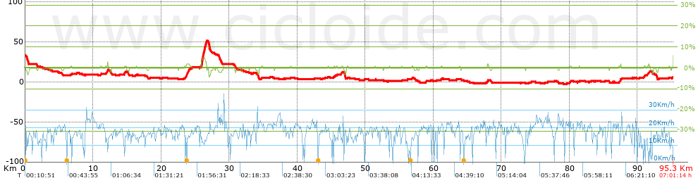
Distance in Km: 95.29
Climb in m: 63
IBP: 43 BYC
 View on STRAVA
Near ...
Ede
Ede

This route belongs to a multi-day journey 14 days documented with 14 independent routes
You can download the tracks of this multi-day route from each of the associated stages .| Day or stage | One day stage | Distance | Climb in | IBP |
| Day 1 | 823608 Rhin 1 Andermatt-Zug 1/2 | 47 Km | 367 m | 34 |
| Day 2 | 823609 Rhin 1 Andermatt-Zug 2/2 | 38 Km | 540 m | 32 |
| Day 3 | 825452 Rhin 2 Zug-Lago Constanza | 108 Km | 897 m | 81 |
| Day 4 | 825451 Rhin 3 Lago Constanza-Bad Zurzach | 86 Km | 449 m | 48 |
| Day 5 | 825599 Rhin 4 Bad Zurzach-Breisach 1/2 | 68 Km | 226 m | 33 |
| Day 6 | 825596 Rhin 4 Bad Zurzach-Breisach 2/2 | 17 Km | 3 m | 9 |
| Day 7 | 826402 Rhin 5 Breisach-Estrasburgo | 81 Km | 40 m | 35 |
| Day 8 | 827389 Rhin 6 Estrasburgo-Karslruhe | 96 Km | 42 m | 44 |
| Day 9 | 827613 Rhin 7 Karlsruhe-Worms Hbf | 99 Km | 45 m | 46 |
| Day 10 | 828705 Rhin 8 Oppenheim-Bingen | 57 Km | 33 m | 27 |
| Day 11 | 828979 Rhin 9 Koblenz-K�lh | 112 Km | 160 m | 62 |
| Day 12 | 829930 Rhin 10 K�lh-Rheinberg | 92 Km | 57 m | 41 |
| Day 13 | 830850 Rhin 11 Rheinberg-Ede | 102 Km | 83 m | 45 |
| Day 14 | 831434 Rhin 12 Ede-Amsterdam y FIN (This) | 95 Km | 63 m | 43 |
| Total 14 days | 1098 Km | 3005 m | 41 / d�a |
Description of the route
Presence of ramps
| Climbs | Distance | % of the total | Speed | Your speed would be | Time | Your time would be | |
| 15 - 30% | 0 | 0 | 0 | ? | 0:00:00 | ? | |
| 10 - 15% | 0 | 0 | 0 | ? | 0:00:00 | ? | |
| 5 - 10% | 0.011 | 0.01 | 5.16 | ? | 0:00:08 | ? | |
| 1 - 5% | 2.652 | 2.78 | 13.08 | ? | 0:12:10 | ? | |
| Total* | 2.663 Km | 2.79 % | 12.99 Km/h | ?
Km/h  |
0:12:18 h | ? h |
|
| Flat | |||||||
| 1 - -1% | 88.828 Km | 93.22 % | 16.22 Km/h | ?
Km/h |
5:28:37 h | ? h |
|
| Descents | |||||||
| -1 - -5% | 3.801 | 3.99 | 19.14 | ? | 0:11:55 | ? | |
| -5 - -10% | 0 | 0 | 0 | ? | 0:00:00 | ? | |
| -10 - -15% | 0 | 0 | 0 | ? | 0:00:00 | ? | |
| -15 - -30% | 0 | 0 | 0 | ? | 0:00:00 | ? | |
| Total* | 3.801 Km | 3.99 % | 19.14 Km/h | ?
Km/h |
0:11:55 h | ? h |
|
How long would it take you?
 |
|
�Cuanto consumir� tu E-BIKE?
Entra tu E-IBP (formato n,nn)
| Detected activity type = () |
| Penalization due to track conditions: 38 % ( > 50 % = MTB, < 50 % = RDB) |
|
|
Correction level applied to the track:
7
 See analyis without corrections See analyis without corrections
|
|
|
| DIFFICULTY OF THE ROUTE |
IBP = 43 BYC |
| According to your statistics Your time in motion would be: ? h |
| Your average speed would be:
? Km/h |
| Total Distance: 95.29 Km |
| Analysed distance: 95.29 Km |
| Linear distance: 67.25 Km |
| Cumulated positive ramps: 62.8 m |
list of points info |
| Cumulated negative ramps: 75.22 m | |
| Maximum height: 51.25 m | |
| Minimum height: -2.89 m | |
| Climbing Ratio: 2.36 % | |
| Descent ratio: 1.98 % | |
| Cumulated postive ramps per Km: 0.66 m | |
| Cumulated negative ramps per Km: 0.79 m | |
| Total time: 7:01:14 h |
| Time in movement: 5:52:50 h |
| According to your statistics Your time in motion would be: ? h
|
| Stopped time: 1:08:24 h |
| Maximum slope filter: ~30 % |
| Minimum separation analysed: ~30 m |
| Number of points: 7681 (cad. 12.41 m) |
| Significant waypoints: 2610 (cad. 36.51 m / 33.98 %) |
| Changes in direction per Km: 14.79 |
| Changes in direction > 5� por Km: 5.99 |
| Cumulated straight stretches: 33.147 Km |
| Straight stretches per Km: 347.85 m |
| Penalized slope changes: 0 |
| Penalized slope changes per Km: 0 |
| Average speed in total: 13.57 Km/h |
| Average speed while moving: 16.2 Km/h |
| According to your statistics Your average speed would be: ? Km/h
|
| Maximum sustained speed: 33.56 Km/h |


