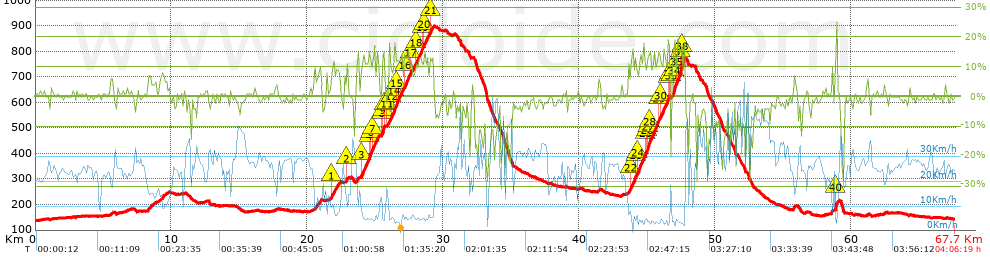
Sella dell'Oca da Iseo Lake (_ Marathon dell'altopiano Stage 2)

MTB
MTB
Ref..: 817758
Published: 07/09/2019
Performed: 07/09/2019
Distance in Km: 67.72
Climb in m: 1604
IBP: 148 BYC

Beppe Cavalli
569 published routes

Add to my Group or Club

 Height in m      Climb in %      Speed in Km/h      Speed < 2 Km/h

Climbs > 10%

Climbs >5% Climbs >10% Climbs >15% Climbs >20% Climbs >25%
 Steep slope of 310 m.   Average slope  Distances  Download as waypoint
1
 Km 21.754  10%  206 m
2
 Km 22.877  11%  104 m
 Steep slope of 1297 m.  Average slope  Distances  Download as waypoint
3
 Km 23.968  12%  581 m
4
 Km 24.549  15%  131 m
5
 Km 24.68  16%  32 m
6
 Km 24.713  13%  99 m
7
 Km 24.812  12%  362 m
8
 Km 25.488  14%  65 m
9
 Km 25.553  18%  94 m
10
 Km 25.647  15%  32 m
 Steep slope of 2482 m.  Average slope  Distances  Download as waypoint
11
 Km 25.894  10%  267 m
12
 Km 26.161  12%  167 m
13
 Km 26.328  12%  67 m
14
 Km 26.395  15%  159 m
15
 Km 26.553  12%  453 m
16
 Km 27.137  13%  457 m
17
 Km 27.595  10%  366 m
18
 Km 27.961  12%  550 m
19
 Km 28.511  11%  96 m
20
 Km 28.607  12%  326 m
21
 Km 29.031  11%  203 m
 Steep slope of 2457 m.  Average slope  Distances  Download as waypoint
22
 Km 43.798  13%  335 m
23
 Km 44.133  11%  169 m
24
 Km 44.302  13%  559 m
25
 Km 44.861  12%  96 m
26
 Km 44.958  13%  160 m
27
 Km 45.117  17%  91 m
28
 Km 45.209  13%  637 m
29
 Km 45.846  11%  100 m
30
 Km 45.946  12%  574 m
31
 Km 46.52  15%  101 m
32
 Km 46.621  17%  35 m
 Steep slope of 924 m.  Average slope  Distances  Download as waypoint
33
 Km 46.792  13%  192 m
34
 Km 46.985  19%  153 m
35
 Km 47.137  13%  287 m
36
 Km 47.424  15%  31 m
37
 Km 47.456  20%  98 m
38
 Km 47.554  18%  163 m
 Steep slope of 170 m.  Average slope  Distances  Download as waypoint
39
 Km 58.827  10%  35 m
40
 Km 58.862  20%  135 m


Description of the route


Presence of ramps


 Climbs  Distance  % of the total  Speed  Your speed would be  Time  Your time would be
   15 - 30%  2.096  3.09  4.5  ?  0:27:58  ?
   10 - 15%  5.974  8.82  6.23  ?  0:57:34  ?
   5 - 10%  4.244  6.27  9.28  ?  0:27:26  ?
   1 - 5%  7.934  11.71  19.3  ?  0:24:40  ?
   Total*  20.247 Km  29.9 %  8.83 Km/h  ? Km/h    2:17:38 h  ? h  
 Flat
   1 - -1%  22.528 Km  33.27 %  25.17 Km/h  ? Km/h    0:53:42 h  ? h  
 Descents
   -1 - -5%  14.611  21.57  29.19  ?  0:30:02  ?
   -5 - -10%  4.79  7.07  34.35  ?  0:08:22  ?
   -10 - -15%  2.904  4.29  37.07  ?  0:04:42  ?
   -15 - -30%  2.642  3.9  21.37  ?  0:07:25  ?
   Total*  24.947 Km  36.84 %  29.63 Km/h  ? Km/h    0:50:31 h  ? h  
* The total has not necessarily coincide with the sum of the partials after correction of errors

How long would it take you?

How long would it take you to cover this route?
There are routes without a valid time information, but with your average stats you can assess the possible duration

Beppe Cavalli to cover this route you've need a time of:   4:01:51 h 
If you sign in and have a minimum of two tracks of this same modality, you can know your time for this route, calculated from your stats..


¿Cuanto consumirá tu E-BIKE?

Entra tu E-IBP (formato n,nn)

E-IBP :   X 148 = 


 Detected activity type =  ()
 Penalization due to track conditions: 61 %   ( > 50 % = MTB, < 50 % = RDB)
 Reliability of the track: A   (1604/79/0/-/-/79)
 Correction level applied to the track: 0
DIFFICULTY OF THE ROUTE
IBP = 148 BYC
According to your statistics
 Your time in motion would be: ? h
Your average speed would be: ? Km/h
 

 Total Distance: 67.72 Km
 Analysed distance: 67.72 Km
 Linear distance: 0.35 Km

 Cumulated positive ramps: 1604.4 m  list of points info
 Cumulated negative ramps: 1593.4 m
 Maximum height: 899.8 m
 Minimum height: 136.2 m
 Climbing Ratio: 7.92 %
 Descent ratio: 6.39 %
 Cumulated postive ramps per Km: 23.69 m
 Cumulated negative ramps per Km: 23.53 m

 Total time: 4:06:19 h
 Time in movement: 4:01:51 h
 According to your statistics
 Your time in motion would be: ? h  
 Stopped time: 0:04:28 h
 Maximum slope filter: ~30 %
 Minimum separation analysed: ~30 m
 Number of points: 4936   (cad. 13.72 m)
 Significant waypoints: 1909   (cad. 35.48 m / 38.68 %)

 Changes in direction per Km: 10.93
 Changes in direction > 5º por Km: 6.45
 Cumulated straight stretches: 20.156 Km
 Straight stretches per Km: 297.64 m
 Penalized slope changes: 11
 Penalized slope changes per Km: 0.162

 Average speed in total: 16.5 Km/h
 Average speed while moving: 16.8 Km/h
 According to your statistics
 Your average speed would be: ? Km/h  
 Maximum sustained speed: 59.29 Km/h


Comments

You can be the first one in commenting this route

 
My comments
:
Add comment  (Registered users)
 
Notify me answers to my comment  Do not notify answers to my comment


Share this route with a friend

Your friend will receive a message with a link to this page:
will see your email and your user name if you do it as registered user.


Write here your name (optional)

E-mail address of your friend(s). You can include various addresses separated by commas

Text or comment (optional) maximum 255 characters long, 255 Available characters

As a non registered users you need to fill-in the captcha text.
  Change image
Type the image characters.
 
 Share with a friend


Visited history

Delete history

Marked routes for review later or compare

My favorites


  Notify anomaly in this route Share in Facebook