La colli Albani e i cinghiali a fare il tifo...___

MTB
MTB
Ref..: 810414
Published: 01/09/2019
Performed: 27/08/2019
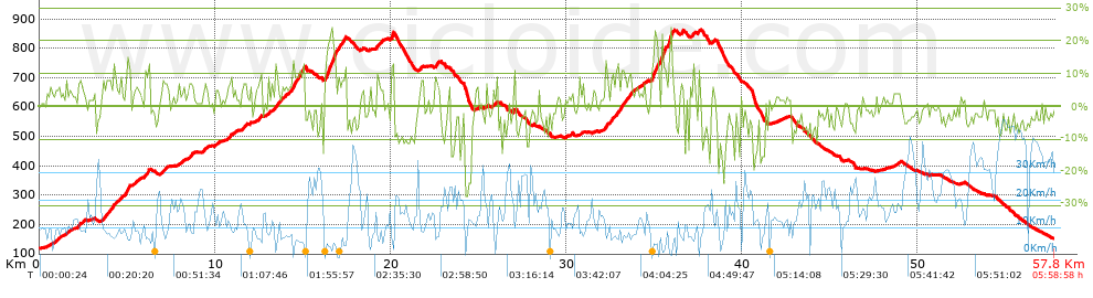
Distance in Km: 57.82
Climb in m: 1517
IBP: 108 BYC

Near ...
Casabianca, Ciampino, Ciampino Aeroporto, Frattocchie, Marino, Santa Maria Delle Mole
Mario_Volpe
Author: Mario_Volpe
582 published routes

Add to my Group or Club

 Height in m      Climb in %      Speed in Km/h      Speed < 2 Km/h

Climbs > 5%

Climbs >5% Climbs >10% Climbs >15% Climbs >20% Climbs >25%
 Steep slope of 102 m.   Average slope  Distances  Download as waypoint
1
 Km 1.112  8%  102 m
 Steep slope of 97 m.  Average slope  Distances  Download as waypoint
2
 Km 1.509  6%  97 m
 Steep slope of 112 m.  Average slope  Distances  Download as waypoint
3
 Km 1.708  6%  112 m
 Steep slope of 242 m.  Average slope  Distances  Download as waypoint
4
 Km 2.21  6%  242 m
 Steep slope of 503 m.  Average slope  Distances  Download as waypoint
5
 Km 3.56  7%  503 m
 Steep slope of 262 m.  Average slope  Distances  Download as waypoint
6
 Km 4.163  8%  262 m
 Steep slope of 130 m.  Average slope  Distances  Download as waypoint
7
 Km 4.599  9%  130 m
 Steep slope of 265 m.  Average slope  Distances  Download as waypoint
8
 Km 4.902  12%  196 m
9
 Km 5.097  12%  69 m
 Steep slope of 216 m.  Average slope  Distances  Download as waypoint
10
 Km 5.31  6%  216 m
 Steep slope of 229 m.  Average slope  Distances  Download as waypoint
11
 Km 5.991  9%  229 m
 Steep slope of 141 m.  Average slope  Distances  Download as waypoint
12
 Km 6.993  7%  141 m
 Steep slope of 306 m.  Average slope  Distances  Download as waypoint
13
 Km 8.501  6%  306 m
 Steep slope of 220 m.  Average slope  Distances  Download as waypoint
14
 Km 9.366  7%  220 m
 Steep slope of 153 m.  Average slope  Distances  Download as waypoint
15
 Km 10.037  5%  153 m
 Steep slope of 251 m.  Average slope  Distances  Download as waypoint
16
 Km 10.697  5%  251 m
 Steep slope of 233 m.  Average slope  Distances  Download as waypoint
17
 Km 11.558  7%  233 m
 Steep slope of 262 m.  Average slope  Distances  Download as waypoint
18
 Km 12.344  6%  262 m
 Steep slope of 334 m.  Average slope  Distances  Download as waypoint
19
 Km 13.222  6%  207 m
20
 Km 13.429  10%  95 m
21
 Km 13.524  9%  32 m
 Steep slope of 159 m.  Average slope  Distances  Download as waypoint
22
 Km 13.656  7%  159 m
 Steep slope of 1153 m.  Average slope  Distances  Download as waypoint
23
 Km 13.914  6%  475 m
24
 Km 14.389  12%  128 m
25
 Km 14.517  10%  260 m
26
 Km 14.777  12%  100 m
27
 Km 14.878  10%  94 m
28
 Km 14.972  12%  96 m
 Steep slope of 1162 m.  Average slope  Distances  Download as waypoint
29
 Km 16.227  8%  34 m
30
 Km 16.261  9%  68 m
31
 Km 16.329  16%  162 m
32
 Km 16.492  15%  386 m
33
 Km 16.878  9%  385 m
34
 Km 17.263  11%  127 m
 Steep slope of 360 m.  Average slope  Distances  Download as waypoint
35
 Km 19.204  8%  360 m
 Steep slope of 162 m.  Average slope  Distances  Download as waypoint
36
 Km 20.02  12%  33 m
37
 Km 20.052  16%  96 m
38
 Km 20.148  13%  33 m
 Steep slope of 99 m.  Average slope  Distances  Download as waypoint
39
 Km 21.682  7%  99 m
 Steep slope of 223 m.  Average slope  Distances  Download as waypoint
40
 Km 22.549  8%  223 m
 Steep slope of 115 m.  Average slope  Distances  Download as waypoint
41
 Km 25.428  7%  115 m
 Steep slope of 201 m.  Average slope  Distances  Download as waypoint
42
 Km 25.787  6%  201 m
 Steep slope of 113 m.  Average slope  Distances  Download as waypoint
43
 Km 27.004  11%  113 m
 Steep slope of 167 m.  Average slope  Distances  Download as waypoint
44
 Km 32.197  10%  167 m
 Steep slope of 1375 m.  Average slope  Distances  Download as waypoint
45
 Km 32.464  7%  644 m
46
 Km 33.108  10%  128 m
47
 Km 33.235  8%  101 m
48
 Km 33.337  8%  502 m
 Steep slope of 151 m.  Average slope  Distances  Download as waypoint
49
 Km 34.3  6%  151 m
 Steep slope of 802 m.  Average slope  Distances  Download as waypoint
50
 Km 34.845  13%  196 m
51
 Km 35.042  16%  96 m
52
 Km 35.138  21%  32 m
53
 Km 35.17  9%  225 m
54
 Km 35.395  17%  187 m
55
 Km 35.582  15%  66 m
 Steep slope of 361 m.  Average slope  Distances  Download as waypoint
56
 Km 35.749  6%  34 m
57
 Km 35.783  14%  65 m
58
 Km 35.848  15%  30 m
59
 Km 35.878  24%  132 m
60
 Km 36.01  11%  32 m
61
 Km 36.041  10%  68 m
 Steep slope of 160 m.  Average slope  Distances  Download as waypoint
62
 Km 36.53  10%  160 m
 Steep slope of 96 m.  Average slope  Distances  Download as waypoint
63
 Km 37.196  11%  96 m
 Steep slope of 131 m.  Average slope  Distances  Download as waypoint
64
 Km 37.496  9%  131 m


Description of the route


Presence of ramps


 Climbs  Distance  % of the total  Speed  Your speed would be  Time  Your time would be
   15 - 30%  1.032  1.78  3.84  ?  0:16:07  ?
   10 - 15%  2.734  4.73  6.13  ?  0:26:45  ?
   5 - 10%  8.873  15.35  8.65  ?  1:01:33  ?
   1 - 5%  13.054  22.58  11.68  ?  1:07:05  ?
   Total*  25.693 Km  44.43 %  8.99 Km/h  ? Km/h    2:51:30 h  ? h  
 Flat
   1 - -1%  6.723 Km  11.63 %  15.98 Km/h  ? Km/h    0:25:15 h  ? h  
 Descents
   -1 - -5%  14.221  24.59  19.58  ?  0:43:35  ?
   -5 - -10%  6.958  12.03  18.9  ?  0:22:05  ?
   -10 - -15%  3.18  5.5  12.73  ?  0:14:59  ?
   -15 - -30%  1.05  1.82  9.5  ?  0:06:38  ?
   Total*  25.408 Km  43.94 %  17.47 Km/h  ? Km/h    1:27:17 h  ? h  
* The total has not necessarily coincide with the sum of the partials after correction of errors

How long would it take you?

How long would it take you to cover this route?
There are routes without a valid time information, but with your average stats you can assess the possible duration

Mario_Volpe to cover this route you've need a time of:   4:44:02 h 
If you sign in and have a minimum of two tracks of this same modality, you can know your time for this route, calculated from your stats..


¿Cuanto consumirá tu E-BIKE?

Entra tu E-IBP (formato n,nn)

E-IBP :   X 108 = 


 Detected activity type =  ()
 Penalization due to track conditions: 60 %   ( > 50 % = MTB, < 50 % = RDB)
 Reliability of the track: B   (1517/66/0/-/-/66)
 Correction level applied to the track: 0
DIFFICULTY OF THE ROUTE
IBP = 108 BYC
According to your statistics
 Your time in motion would be: ? h
Your average speed would be: ? Km/h
 

 Total Distance: 57.82 Km
 Analysed distance: 57.82 Km
 Linear distance: 1.12 Km

 Cumulated positive ramps: 1516.6 m  list of points info
 Cumulated negative ramps: 1484.8 m
 Maximum height: 863.2 m
 Minimum height: 118.2 m
 Climbing Ratio: 5.9 %
 Descent ratio: 5.84 %
 Cumulated postive ramps per Km: 26.23 m
 Cumulated negative ramps per Km: 25.68 m

 Total time: 5:58:58 h
 Time in movement: 4:44:02 h
 According to your statistics
 Your time in motion would be: ? h  
 Stopped time: 1:14:56 h
 Maximum slope filter: ~30 %
 Minimum separation analysed: ~30 m
 Number of points: 4726   (cad. 12.24 m)
 Significant waypoints: 1645   (cad. 35.15 m / 34.81 %)

 Changes in direction per Km: 13.09
 Changes in direction > 5º por Km: 7
 Cumulated straight stretches: 18.42 Km
 Straight stretches per Km: 318.57 m
 Penalized slope changes: 17
 Penalized slope changes per Km: 0.294

 Average speed in total: 9.67 Km/h
 Average speed while moving: 12.21 Km/h
 According to your statistics
 Your average speed would be: ? Km/h  
 Maximum sustained speed: 52.28 Km/h


Comments

You can be the first one in commenting this route

 
My comments
:
Add comment  (Registered users)
 
Notify me answers to my comment  Do not notify answers to my comment


Share this route with a friend

Your friend will receive a message with a link to this page:
will see your email and your user name if you do it as registered user.


Write here your name (optional)

E-mail address of your friend(s). You can include various addresses separated by commas

Text or comment (optional) maximum 255 characters long, 255 Available characters

As a non registered users you need to fill-in the captcha text.
  Change image
Type the image characters.
 
 Share with a friend


Visited history

Delete history

Marked routes for review later or compare

My favorites


  Notify anomaly in this route Share in Facebook