Salida por la tarde

MTB
MTB
Ref..: 808963
Published: 01/09/2019
Performed: 28/08/2019
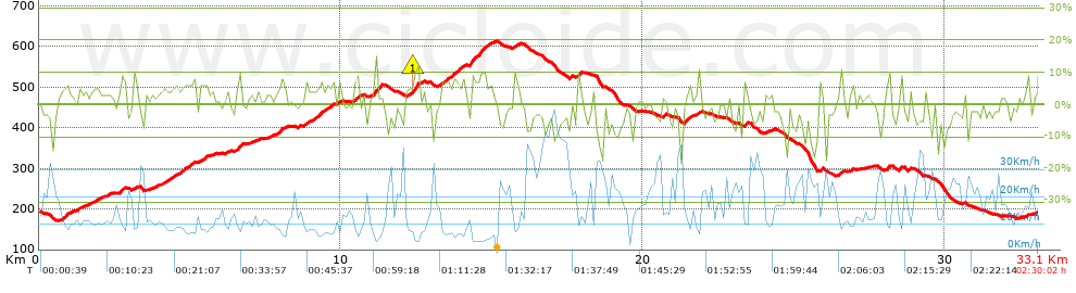
Distance in Km: 33.08
Climb in m: 703
IBP: 46 BYC

Salvador_Demures
119 published routes

Add to my Group or Club

 Height in m      Climb in %      Speed in Km/h      Speed < 2 Km/h

Climbs > 5%

Climbs >5% Climbs >10% Climbs >15% Climbs >20% Climbs >25%
 Steep slope of 204 m.   Average slope  Distances  Download as waypoint
1
 Km 0.772  7%  204 m
 Steep slope of 143 m.  Average slope  Distances  Download as waypoint
2
 Km 2.661  6%  143 m
 Steep slope of 139 m.  Average slope  Distances  Download as waypoint
3
 Km 3.147  7%  139 m
 Steep slope of 153 m.  Average slope  Distances  Download as waypoint
4
 Km 4.537  5%  153 m
 Steep slope of 295 m.  Average slope  Distances  Download as waypoint
5
 Km 4.82  6%  295 m
 Steep slope of 220 m.  Average slope  Distances  Download as waypoint
6
 Km 5.312  5%  220 m
 Steep slope of 147 m.  Average slope  Distances  Download as waypoint
7
 Km 6.564  9%  147 m
 Steep slope of 256 m.  Average slope  Distances  Download as waypoint
8
 Km 7.872  6%  256 m
 Steep slope of 129 m.  Average slope  Distances  Download as waypoint
9
 Km 8.774  5%  129 m
 Steep slope of 349 m.  Average slope  Distances  Download as waypoint
10
 Km 9.154  6%  349 m
 Steep slope of 102 m.  Average slope  Distances  Download as waypoint
11
 Km 9.682  7%  102 m
 Steep slope of 190 m.  Average slope  Distances  Download as waypoint
12
 Km 10.425  8%  190 m
 Steep slope of 186 m.  Average slope  Distances  Download as waypoint
13
 Km 11.083  9%  186 m
 Steep slope of 210 m.  Average slope  Distances  Download as waypoint
14
 Km 12.414  12%  174 m
15
 Km 12.588  6%  36 m
 Steep slope of 423 m.  Average slope  Distances  Download as waypoint
16
 Km 13.314  6%  423 m
 Steep slope of 231 m.  Average slope  Distances  Download as waypoint
17
 Km 13.838  6%  231 m
 Steep slope of 540 m.  Average slope  Distances  Download as waypoint
18
 Km 14.265  9%  540 m
 Steep slope of 156 m.  Average slope  Distances  Download as waypoint
19
 Km 14.902  5%  156 m
 Steep slope of 111 m.  Average slope  Distances  Download as waypoint
20
 Km 15.713  7%  111 m
 Steep slope of 108 m.  Average slope  Distances  Download as waypoint
21
 Km 17.839  10%  108 m
 Steep slope of 156 m.  Average slope  Distances  Download as waypoint
22
 Km 21.351  8%  156 m
 Steep slope of 116 m.  Average slope  Distances  Download as waypoint
23
 Km 21.784  8%  116 m
 Steep slope of 118 m.  Average slope  Distances  Download as waypoint
24
 Km 23.326  8%  118 m
 Steep slope of 92 m.  Average slope  Distances  Download as waypoint
25
 Km 25.846  10%  92 m
 Steep slope of 116 m.  Average slope  Distances  Download as waypoint
26
 Km 26.478  7%  116 m
 Steep slope of 101 m.  Average slope  Distances  Download as waypoint
27
 Km 28.027  6%  101 m
 Steep slope of 106 m.  Average slope  Distances  Download as waypoint
28
 Km 32.686  7%  106 m


Description of the route


Presence of ramps


 Climbs  Distance  % of the total  Speed  Your speed would be  Time  Your time would be
   15 - 30%  0.106  0.32  6.95  ?  0:00:55  ?
   10 - 15%  0.659  1.99  7.02  ?  0:05:38  ?
   5 - 10%  5.098  15.41  8.24  ?  0:37:06  ?
   1 - 5%  8.738  26.41  11  ?  0:47:40  ?
   Total*  14.6 Km  44.13 %  9.59 Km/h  ? Km/h    1:31:19 h  ? h  
 Flat
   1 - -1%  4.934 Km  14.91 %  15.72 Km/h  ? Km/h    0:18:50 h  ? h  
 Descents
   -1 - -5%  8.517  25.74  21.19  ?  0:24:07  ?
   -5 - -10%  3.342  10.1  25.82  ?  0:07:46  ?
   -10 - -15%  1.183  3.58  24.06  ?  0:02:57  ?
   -15 - -30%  0.507  1.53  22.8  ?  0:01:20  ?
   Total*  13.549 Km  40.95 %  22.48 Km/h  ? Km/h    0:36:10 h  ? h  
* The total has not necessarily coincide with the sum of the partials after correction of errors

How long would it take you?

How long would it take you to cover this route?
There are routes without a valid time information, but with your average stats you can assess the possible duration

Salvador_Demures to cover this route you've need a time of:   2:26:19 h 
If you sign in and have a minimum of two tracks of this same modality, you can know your time for this route, calculated from your stats..


¿Cuanto consumirá tu E-BIKE?

Entra tu E-IBP (formato n,nn)

E-IBP :   X 46 = 


 Detected activity type =  ()
 Penalization due to track conditions: 69 %   ( > 50 % = MTB, < 50 % = RDB)
 Reliability of the track: B   (703/63/0/-/-/63)
 Correction level applied to the track: 0
DIFFICULTY OF THE ROUTE
IBP = 46 BYC
According to your statistics
 Your time in motion would be: ? h
Your average speed would be: ? Km/h
 

 Total Distance: 33.08 Km
 Analysed distance: 33.08 Km
 Linear distance: 0.01 Km

 Cumulated positive ramps: 702.6 m  list of points info
 Cumulated negative ramps: 700 m
 Maximum height: 612.8 m
 Minimum height: 171 m
 Climbing Ratio: 4.81 %
 Descent ratio: 5.17 %
 Cumulated postive ramps per Km: 21.24 m
 Cumulated negative ramps per Km: 21.16 m

 Total time: 2:30:02 h
 Time in movement: 2:26:19 h
 According to your statistics
 Your time in motion would be: ? h  
 Stopped time: 0:03:43 h
 Maximum slope filter: ~30 %
 Minimum separation analysed: ~30 m
 Number of points: 1850   (cad. 17.88 m)
 Significant waypoints: 839   (cad. 39.43 m / 45.35 %)

 Changes in direction per Km: 11.03
 Changes in direction > 5º por Km: 7.35
 Cumulated straight stretches: 7.026 Km
 Straight stretches per Km: 212.39 m
 Penalized slope changes: 4
 Penalized slope changes per Km: 0.121

 Average speed in total: 13.23 Km/h
 Average speed while moving: 13.57 Km/h
 According to your statistics
 Your average speed would be: ? Km/h  
 Maximum sustained speed: 53.73 Km/h


Comments

You can be the first one in commenting this route

 
My comments
:
Add comment  (Registered users)
 
Notify me answers to my comment  Do not notify answers to my comment


Share this route with a friend

Your friend will receive a message with a link to this page:
will see your email and your user name if you do it as registered user.


Write here your name (optional)

E-mail address of your friend(s). You can include various addresses separated by commas

Text or comment (optional) maximum 255 characters long, 255 Available characters

As a non registered users you need to fill-in the captcha text.
  Change image
Type the image characters.
 
 Share with a friend


Visited history

Delete history

Marked routes for review later or compare

My favorites


  Notify anomaly in this route Share in Facebook