Jaen (Jaén)

MTB
MTB
Ref..: 808094
Published: 31/08/2019
Performed: 27/08/2019
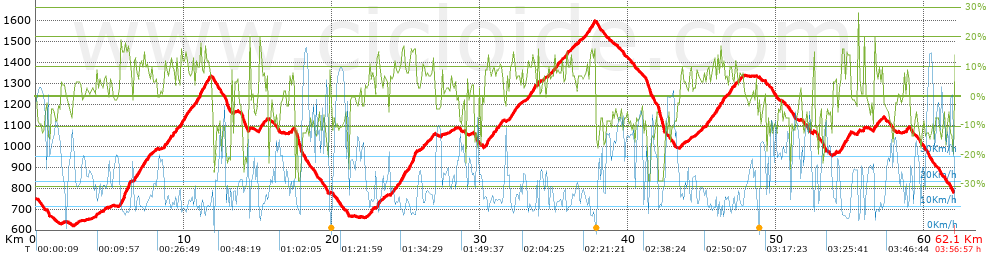
Distance in Km: 62.08
Climb in m: 2580
IBP: 200 BYC


 Height in m      Climb in %      Speed in Km/h      Speed < 2 Km/h

Climbs > 5%

Climbs >5% Climbs >10% Climbs >15% Climbs >20% Climbs >25%
 Steep slope of 106 m.   Average slope  Distances  Download as waypoint
1
 Km 2.652  5%  106 m
 Steep slope of 235 m.  Average slope  Distances  Download as waypoint
2
 Km 3.914  5%  235 m
 Steep slope of 225 m.  Average slope  Distances  Download as waypoint
3
 Km 4.599  6%  225 m
 Steep slope of 767 m.  Average slope  Distances  Download as waypoint
4
 Km 5.71  5%  38 m
5
 Km 5.749  17%  289 m
6
 Km 6.038  15%  101 m
7
 Km 6.139  18%  208 m
8
 Km 6.347  13%  43 m
9
 Km 6.39  7%  88 m
 Steep slope of 1272 m.  Average slope  Distances  Download as waypoint
10
 Km 6.627  13%  191 m
11
 Km 6.818  9%  147 m
12
 Km 6.965  11%  552 m
13
 Km 7.517  9%  382 m
 Steep slope of 150 m.  Average slope  Distances  Download as waypoint
14
 Km 8.067  6%  150 m
 Steep slope of 996 m.  Average slope  Distances  Download as waypoint
15
 Km 8.677  11%  185 m
16
 Km 8.861  9%  131 m
17
 Km 8.993  11%  151 m
18
 Km 9.144  9%  529 m
 Steep slope of 866 m.  Average slope  Distances  Download as waypoint
19
 Km 9.794  13%  473 m
20
 Km 10.267  9%  393 m
 Steep slope of 1095 m.  Average slope  Distances  Download as waypoint
21
 Km 10.756  8%  79 m
22
 Km 10.835  12%  219 m
23
 Km 11.054  16%  226 m
24
 Km 11.28  12%  385 m
25
 Km 11.665  9%  186 m
 Steep slope of 612 m.  Average slope  Distances  Download as waypoint
26
 Km 15.083  13%  273 m
27
 Km 15.356  9%  339 m
 Steep slope of 245 m.  Average slope  Distances  Download as waypoint
28
 Km 17.129  7%  245 m
 Steep slope of 133 m.  Average slope  Distances  Download as waypoint
29
 Km 19.811  10%  133 m
 Steep slope of 386 m.  Average slope  Distances  Download as waypoint
30
 Km 22.483  10%  170 m
31
 Km 22.652  9%  216 m
 Steep slope of 549 m.  Average slope  Distances  Download as waypoint
32
 Km 23.026  13%  30 m
33
 Km 23.056  16%  103 m
34
 Km 23.16  11%  37 m
35
 Km 23.197  7%  379 m
 Steep slope of 1817 m.  Average slope  Distances  Download as waypoint
36
 Km 23.929  8%  321 m
37
 Km 24.25  11%  112 m
38
 Km 24.361  9%  189 m
39
 Km 24.55  12%  430 m
40
 Km 24.98  8%  180 m
41
 Km 25.16  12%  184 m
42
 Km 25.344  17%  299 m
43
 Km 25.643  16%  62 m
44
 Km 25.704  9%  40 m
 Steep slope of 835 m.  Average slope  Distances  Download as waypoint
45
 Km 26.036  5%  90 m
46
 Km 26.127  11%  109 m
47
 Km 26.235  8%  560 m
48
 Km 26.796  12%  76 m
 Steep slope of 100 m.  Average slope  Distances  Download as waypoint
49
 Km 27.973  6%  100 m
 Steep slope of 1346 m.  Average slope  Distances  Download as waypoint
50
 Km 30.266  9%  204 m
51
 Km 30.47  14%  195 m
52
 Km 30.665  8%  192 m
53
 Km 30.857  12%  117 m
54
 Km 30.974  9%  351 m
55
 Km 31.325  10%  109 m
56
 Km 31.434  8%  178 m
 Steep slope of 730 m.  Average slope  Distances  Download as waypoint
57
 Km 31.991  8%  50 m
58
 Km 32.041  12%  287 m
59
 Km 32.328  9%  393 m
 Steep slope of 804 m.  Average slope  Distances  Download as waypoint
60
 Km 33.139  7%  72 m
61
 Km 33.211  11%  452 m
62
 Km 33.663  8%  280 m
 Steep slope of 375 m.  Average slope  Distances  Download as waypoint
63
 Km 34.239  6%  375 m
 Steep slope of 1310 m.  Average slope  Distances  Download as waypoint
64
 Km 34.713  8%  1135 m
65
 Km 35.848  11%  143 m
66
 Km 35.991  9%  32 m
 Steep slope of 310 m.  Average slope  Distances  Download as waypoint
67
 Km 36.122  8%  310 m
 Steep slope of 1147 m.  Average slope  Distances  Download as waypoint
68
 Km 36.575  7%  575 m
69
 Km 37.15  10%  110 m
70
 Km 37.261  8%  189 m
71
 Km 37.45  13%  273 m
 Steep slope of 337 m.  Average slope  Distances  Download as waypoint
72
 Km 43.497  7%  337 m
 Steep slope of 138 m.  Average slope  Distances  Download as waypoint
73
 Km 44.106  7%  138 m
 Steep slope of 358 m.  Average slope  Distances  Download as waypoint
74
 Km 44.513  6%  358 m
 Steep slope of 1698 m.  Average slope  Distances  Download as waypoint
75
 Km 44.984  7%  280 m
76
 Km 45.264  10%  299 m
77
 Km 45.563  10%  158 m
78
 Km 45.72  8%  102 m
79
 Km 45.823  11%  544 m
80
 Km 46.367  17%  98 m
81
 Km 46.464  7%  217 m
 Steep slope of 783 m.  Average slope  Distances  Download as waypoint
82
 Km 46.796  6%  34 m
83
 Km 46.83  12%  141 m
84
 Km 46.971  8%  608 m
 Steep slope of 121 m.  Average slope  Distances  Download as waypoint
85
 Km 47.719  8%  121 m
 Steep slope of 119 m.  Average slope  Distances  Download as waypoint
86
 Km 52.491  10%  119 m
 Steep slope of 167 m.  Average slope  Distances  Download as waypoint
87
 Km 53.873  7%  167 m
 Steep slope of 734 m.  Average slope  Distances  Download as waypoint
88
 Km 54.265  9%  150 m
89
 Km 54.415  15%  149 m
90
 Km 54.565  8%  175 m
91
 Km 54.74  16%  110 m
92
 Km 54.85  14%  111 m
93
 Km 54.961  17%  39 m
 Steep slope of 121 m.  Average slope  Distances  Download as waypoint
94
 Km 55.535  16%  121 m
 Steep slope of 118 m.  Average slope  Distances  Download as waypoint
95
 Km 55.894  12%  118 m
 Steep slope of 542 m.  Average slope  Distances  Download as waypoint
96
 Km 56.613  15%  118 m
97
 Km 56.73  9%  37 m
98
 Km 56.768  9%  387 m
 Steep slope of 258 m.  Average slope  Distances  Download as waypoint
99
 Km 58.621  7%  258 m


Description of the route


Presence of ramps


 Climbs  Distance  % of the total  Speed  Your speed would be  Time  Your time would be
   15 - 30%  2.854  4.6  7.52  ?  0:22:46  ?
   10 - 15%  7.51  12.1  10.54  ?  0:42:45  ?
   5 - 10%  12.389  19.96  14.57  ?  0:51:00  ?
   1 - 5%  8.348  13.45  21.13  ?  0:23:42  ?
   Total*  31.101 Km  50.1 %  13.31 Km/h  ? Km/h    2:20:13 h  ? h  
 Flat
   1 - -1%  3.853 Km  6.21 %  24.16 Km/h  ? Km/h    0:09:34 h  ? h  
 Descents
   -1 - -5%  6.848  11.03  23.34  ?  0:17:36  ?
   -5 - -10%  9.553  15.39  35.71  ?  0:16:03  ?
   -10 - -15%  6.97  11.23  32.42  ?  0:12:54  ?
   -15 - -30%  3.754  6.05  18.39  ?  0:12:15  ?
   Total*  27.124 Km  43.69 %  27.68 Km/h  ? Km/h    0:58:48 h  ? h  
* The total has not necessarily coincide with the sum of the partials after correction of errors

How long would it take you?

How long would it take you to cover this route?
There are routes without a valid time information, but with your average stats you can assess the possible duration

Jose_Manuel_Diaz_Gallego to cover this route you've need a time of:   3:28:35 h 
If you sign in and have a minimum of two tracks of this same modality, you can know your time for this route, calculated from your stats..


¿Cuanto consumirá tu E-BIKE?

Entra tu E-IBP (formato n,nn)

E-IBP :   X 200 = 


 Detected activity type =  ()
 Penalization due to track conditions: 64 %   ( > 50 % = MTB, < 50 % = RDB)
 Reliability of the track: A   (2580/87/0/-/-/87)
 Correction level applied to the track: 0
DIFFICULTY OF THE ROUTE
IBP = 200 BYC
According to your statistics
 Your time in motion would be: ? h
Your average speed would be: ? Km/h
 

 Total Distance: 62.08 Km
 Analysed distance: 62.08 Km
 Linear distance: 0.17 Km

 Cumulated positive ramps: 2579.6 m  list of points info
 Cumulated negative ramps: 2550.8 m
 Maximum height: 1602.8 m
 Minimum height: 621.8 m
 Climbing Ratio: 8.29 %
 Descent ratio: 9.4 %
 Cumulated postive ramps per Km: 41.55 m
 Cumulated negative ramps per Km: 41.09 m

 Total time: 3:56:57 h
 Time in movement: 3:28:35 h
 According to your statistics
 Your time in motion would be: ? h  
 Stopped time: 0:28:22 h
 Maximum slope filter: ~30 %
 Minimum separation analysed: ~30 m
 Number of points: 3796   (cad. 16.35 m)
 Significant waypoints: 1619   (cad. 38.34 m / 42.65 %)

 Changes in direction per Km: 10.15
 Changes in direction > 5º por Km: 6.93
 Cumulated straight stretches: 10.603 Km
 Straight stretches per Km: 170.8 m
 Penalized slope changes: 18
 Penalized slope changes per Km: 0.29

 Average speed in total: 15.72 Km/h
 Average speed while moving: 17.86 Km/h
 According to your statistics
 Your average speed would be: ? Km/h  
 Maximum sustained speed: 75.09 Km/h


Comments

You can be the first one in commenting this route

 
My comments
:
Add comment  (Registered users)
 
Notify me answers to my comment  Do not notify answers to my comment


Share this route with a friend

Your friend will receive a message with a link to this page:
will see your email and your user name if you do it as registered user.


Write here your name (optional)

E-mail address of your friend(s). You can include various addresses separated by commas

Text or comment (optional) maximum 255 characters long, 255 Available characters

As a non registered users you need to fill-in the captcha text.
  Change image
Type the image characters.
 
 Share with a friend


Visited history

Delete history

Marked routes for review later or compare

My favorites


  Notify anomaly in this route Share in Facebook