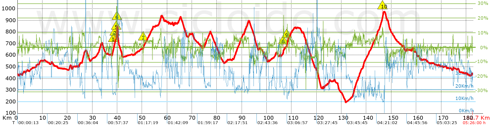
La indurain 2019. General P-22 /Subida cronometrada P-28 /Muy muy contento con el resultado, con 220...

Road
Road
Ref..: 779668
Published: 26/07/2019
Performed: 20/07/2019
Distance in Km: 182.7
Climb in m: 3358
IBP: 226 BYC

hfo
Author: hfo
67 published routes

Add to my Group or Club

 Height in m      Climb in %      Speed in Km/h      Speed < 2 Km/h

Climbs > 5%

Climbs >5% Climbs >10% Climbs >15% Climbs >20% Climbs >25%
 Steep slope of 112 m.   Average slope  Distances  Download as waypoint
1
 Km 0.718  8%  112 m
 Steep slope of 107 m.  Average slope  Distances  Download as waypoint
2
 Km 2.1  7%  107 m
 Steep slope of 179 m.  Average slope  Distances  Download as waypoint
3
 Km 8.697  7%  179 m
 Steep slope of 170 m.  Average slope  Distances  Download as waypoint
4
 Km 13.519  6%  170 m
 Steep slope of 348 m.  Average slope  Distances  Download as waypoint
5
 Km 20.802  7%  348 m
 Steep slope of 180 m.  Average slope  Distances  Download as waypoint
6
 Km 22.034  8%  180 m
 Steep slope of 307 m.  Average slope  Distances  Download as waypoint
7
 Km 24.676  7%  307 m
 Steep slope of 966 m.  Average slope  Distances  Download as waypoint
8
 Km 25.95  9%  966 m
 Steep slope of 990 m.  Average slope  Distances  Download as waypoint
9
 Km 32.589  7%  990 m
 Steep slope of 1945 m.  Average slope  Distances  Download as waypoint
10
 Km 38.019  9%  423 m
11
 Km 38.443  10%  139 m
12
 Km 38.582  9%  462 m
13
 Km 39.044  10%  241 m
14
 Km 39.285  7%  324 m
15
 Km 39.609  11%  45 m
16
 Km 39.654  24%  35 m
17
 Km 39.688  28%  276 m
 Steep slope of 43 m.  Average slope  Distances  Download as waypoint
18
 Km 39.994  15%  43 m
 Steep slope of 250 m.  Average slope  Distances  Download as waypoint
19
 Km 50.463  7%  32 m
20
 Km 50.495  12%  148 m
21
 Km 50.643  7%  70 m
 Steep slope of 113 m.  Average slope  Distances  Download as waypoint
22
 Km 52.165  5%  113 m
 Steep slope of 165 m.  Average slope  Distances  Download as waypoint
23
 Km 53.339  5%  165 m
 Steep slope of 275 m.  Average slope  Distances  Download as waypoint
24
 Km 54.19  8%  275 m
 Steep slope of 911 m.  Average slope  Distances  Download as waypoint
25
 Km 56.759  7%  911 m
 Steep slope of 170 m.  Average slope  Distances  Download as waypoint
26
 Km 61.935  7%  170 m
 Steep slope of 102 m.  Average slope  Distances  Download as waypoint
27
 Km 62.767  6%  102 m
 Steep slope of 99 m.  Average slope  Distances  Download as waypoint
28
 Km 64.209  6%  99 m
 Steep slope of 292 m.  Average slope  Distances  Download as waypoint
29
 Km 64.586  6%  292 m
 Steep slope of 191 m.  Average slope  Distances  Download as waypoint
30
 Km 65.074  6%  191 m
 Steep slope of 167 m.  Average slope  Distances  Download as waypoint
31
 Km 74.901  5%  167 m
 Steep slope of 873 m.  Average slope  Distances  Download as waypoint
32
 Km 75.171  6%  873 m
 Steep slope of 91 m.  Average slope  Distances  Download as waypoint
33
 Km 76.132  5%  91 m
 Steep slope of 120 m.  Average slope  Distances  Download as waypoint
34
 Km 76.368  5%  120 m
 Steep slope of 113 m.  Average slope  Distances  Download as waypoint
35
 Km 76.652  5%  113 m
 Steep slope of 254 m.  Average slope  Distances  Download as waypoint
36
 Km 76.919  5%  254 m
 Steep slope of 160 m.  Average slope  Distances  Download as waypoint
37
 Km 77.292  6%  160 m
 Steep slope of 376 m.  Average slope  Distances  Download as waypoint
38
 Km 86.816  7%  376 m
 Steep slope of 483 m.  Average slope  Distances  Download as waypoint
39
 Km 87.334  7%  483 m
 Steep slope of 300 m.  Average slope  Distances  Download as waypoint
40
 Km 87.958  7%  300 m
 Steep slope of 151 m.  Average slope  Distances  Download as waypoint
41
 Km 88.453  5%  151 m
 Steep slope of 244 m.  Average slope  Distances  Download as waypoint
42
 Km 88.75  5%  244 m
 Steep slope of 515 m.  Average slope  Distances  Download as waypoint
43
 Km 89.117  6%  515 m
 Steep slope of 439 m.  Average slope  Distances  Download as waypoint
44
 Km 89.751  6%  439 m
 Steep slope of 785 m.  Average slope  Distances  Download as waypoint
45
 Km 90.867  7%  785 m
 Steep slope of 663 m.  Average slope  Distances  Download as waypoint
46
 Km 92.04  6%  663 m
 Steep slope of 199 m.  Average slope  Distances  Download as waypoint
47
 Km 103.333  6%  199 m
 Steep slope of 140 m.  Average slope  Distances  Download as waypoint
48
 Km 103.678  6%  140 m
 Steep slope of 114 m.  Average slope  Distances  Download as waypoint
49
 Km 105.249  6%  114 m
 Steep slope of 220 m.  Average slope  Distances  Download as waypoint
50
 Km 106.563  7%  111 m
51
 Km 106.675  16%  109 m
 Steep slope of 721 m.  Average slope  Distances  Download as waypoint
52
 Km 108.05  10%  41 m
53
 Km 108.091  13%  208 m
54
 Km 108.299  8%  472 m
 Steep slope of 351 m.  Average slope  Distances  Download as waypoint
55
 Km 109.01  6%  351 m
 Steep slope of 301 m.  Average slope  Distances  Download as waypoint
56
 Km 109.485  6%  301 m
 Steep slope of 117 m.  Average slope  Distances  Download as waypoint
57
 Km 110.103  5%  117 m
 Steep slope of 141 m.  Average slope  Distances  Download as waypoint
58
 Km 120.003  8%  141 m
 Steep slope of 219 m.  Average slope  Distances  Download as waypoint
59
 Km 125.12  7%  219 m
 Steep slope of 182 m.  Average slope  Distances  Download as waypoint
60
 Km 134.281  5%  182 m
 Steep slope of 811 m.  Average slope  Distances  Download as waypoint
61
 Km 134.568  8%  811 m
 Steep slope of 748 m.  Average slope  Distances  Download as waypoint
62
 Km 135.484  7%  748 m
 Steep slope of 384 m.  Average slope  Distances  Download as waypoint
63
 Km 136.457  7%  384 m
 Steep slope of 389 m.  Average slope  Distances  Download as waypoint
64
 Km 137.038  7%  389 m
 Steep slope of 253 m.  Average slope  Distances  Download as waypoint
65
 Km 137.615  8%  253 m
 Steep slope of 703 m.  Average slope  Distances  Download as waypoint
66
 Km 138.633  8%  703 m
 Steep slope of 323 m.  Average slope  Distances  Download as waypoint
67
 Km 140.924  6%  323 m
 Steep slope of 114 m.  Average slope  Distances  Download as waypoint
68
 Km 141.797  5%  114 m
 Steep slope of 183 m.  Average slope  Distances  Download as waypoint
69
 Km 142.019  6%  183 m
 Steep slope of 101 m.  Average slope  Distances  Download as waypoint
70
 Km 142.354  7%  101 m
 Steep slope of 334 m.  Average slope  Distances  Download as waypoint
71
 Km 142.587  6%  334 m
 Steep slope of 298 m.  Average slope  Distances  Download as waypoint
72
 Km 143.707  7%  298 m
 Steep slope of 422 m.  Average slope  Distances  Download as waypoint
73
 Km 144.123  8%  422 m
 Steep slope of 1895 m.  Average slope  Distances  Download as waypoint
74
 Km 145.072  7%  1367 m
75
 Km 146.439  11%  278 m
76
 Km 146.717  8%  250 m
 Steep slope of 128 m.  Average slope  Distances  Download as waypoint
77
 Km 154.751  9%  128 m
 Steep slope of 199 m.  Average slope  Distances  Download as waypoint
78
 Km 158.27  6%  199 m
 Steep slope of 256 m.  Average slope  Distances  Download as waypoint
79
 Km 174.728  8%  256 m
 Steep slope of 135 m.  Average slope  Distances  Download as waypoint
80
 Km 182.315  7%  135 m


Description of the route


Presence of ramps


 Climbs  Distance  % of the total  Speed  Your speed would be  Time  Your time would be
   15 - 30%  0.587  0.32  27.45  ?  0:01:17  ?
   10 - 15%  2.242  1.23  18.77  ?  0:07:10  ?
   5 - 10%  23.628  12.93  21.12  ?  1:07:08  ?
   1 - 5%  46.429  25.41  28.76  ?  1:36:52  ?
   Total*  72.886 Km  39.89 %  25.36 Km/h  ? Km/h    2:52:27 h  ? h  
 Flat
   1 - -1%  41.678 Km  22.81 %  38.11 Km/h  ? Km/h    1:05:37 h  ? h  
 Descents
   -1 - -5%  38.507  21.08  42.91  ?  0:53:51  ?
   -5 - -10%  26.274  14.38  51.57  ?  0:30:34  ?
   -10 - -15%  2.343  1.28  49.61  ?  0:02:50  ?
   -15 - -30%  1.012  0.55  88.9  ?  0:00:41  ?
   Total*  68.136 Km  37.29 %  46.49 Km/h  ? Km/h    1:27:56 h  ? h  
* The total has not necessarily coincide with the sum of the partials after correction of errors

How long would it take you?

How long would it take you to cover this route?
There are routes without a valid time information, but with your average stats you can assess the possible duration

hfo to cover this route you've need a time of:   5:26:00 h 
If you sign in and have a minimum of two tracks of this same modality, you can know your time for this route, calculated from your stats..


¿Cuanto consumirá tu E-BIKE?

Entra tu E-IBP (formato n,nn)

E-IBP :   X 226 = 


 Detected activity type =  ()
 Penalization due to track conditions: 37 %   ( > 50 % = MTB, < 50 % = RDB)
 Reliability of the track: A   (3359/75/0/-/-/75)
 Correction level applied to the track: 0
DIFFICULTY OF THE ROUTE
IBP = 226 BYC
According to your statistics
 Your time in motion would be: ? h
Your average speed would be: ? Km/h
 

 Total Distance: 182.7 Km
 Analysed distance: 182.7 Km
 Linear distance: 0.06 Km

 Cumulated positive ramps: 3358.2 m  list of points info
 Cumulated negative ramps: 3358.8 m
 Maximum height: 972.6 m
 Minimum height: 195.3 m
 Climbing Ratio: 4.61 %
 Descent ratio: 4.93 %
 Cumulated postive ramps per Km: 18.38 m
 Cumulated negative ramps per Km: 18.38 m

 Total time: 5:26:00 h
 Time in movement: 5:26:00 h
 According to your statistics
 Your time in motion would be: ? h  
 Stopped time: 0:00:00 h
 Maximum slope filter: ~30 %
 Minimum separation analysed: ~30 m
 Number of points: 13274   (cad. 13.76 m)
 Significant waypoints: 5128   (cad. 35.63 m / 38.63 %)

 Changes in direction per Km: 7.88
 Changes in direction > 5º por Km: 3.98
 Cumulated straight stretches: 65.822 Km
 Straight stretches per Km: 360.27 m
 Penalized slope changes: 34
 Penalized slope changes per Km: 0.186

 Average speed in total: 33.63 Km/h
 Average speed while moving: 33.63 Km/h
 According to your statistics
 Your average speed would be: ? Km/h  
 Maximum sustained speed: 80.63 Km/h


Comments

You can be the first one in commenting this route

 
My comments
:
Add comment  (Registered users)
 
Notify me answers to my comment  Do not notify answers to my comment


Share this route with a friend

Your friend will receive a message with a link to this page:
will see your email and your user name if you do it as registered user.


Write here your name (optional)

E-mail address of your friend(s). You can include various addresses separated by commas

Text or comment (optional) maximum 255 characters long, 255 Available characters

As a non registered users you need to fill-in the captcha text.
  Change image
Type the image characters.
 
 Share with a friend


Visited history

Delete history

Marked routes for review later or compare

My favorites


  Notify anomaly in this route Share in Facebook