Unas Moras - Santi Petri TrackTrack

MTB
MTB
Ref..: 775791
Published: 17/07/2019
Performed: 16/07/2019
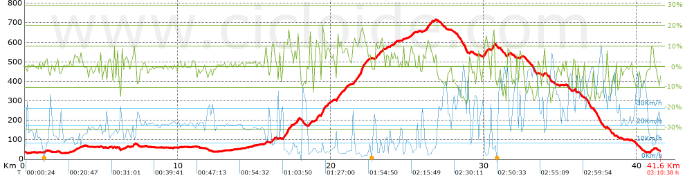
Distance in Km: 41.57
Climb in m: 1075
IBP: 90 BYC

Near ...
Cartama, Cartama, Ampliacion, Casapalma, Fahala, Villafranco Del Guadalhorce

 Height in m      Climb in %      Speed in Km/h      Speed < 2 Km/h

Climbs > 5%

Climbs >5% Climbs >10% Climbs >15% Climbs >20% Climbs >25%
 Steep slope of 179 m.   Average slope  Distances  Download as waypoint
1
 Km 3.207  6%  179 m
 Steep slope of 177 m.  Average slope  Distances  Download as waypoint
2
 Km 7.027  8%  177 m
 Steep slope of 110 m.  Average slope  Distances  Download as waypoint
3
 Km 15.724  8%  110 m
 Steep slope of 242 m.  Average slope  Distances  Download as waypoint
4
 Km 16.092  8%  242 m
 Steep slope of 591 m.  Average slope  Distances  Download as waypoint
5
 Km 16.874  13%  481 m
6
 Km 17.355  9%  110 m
 Steep slope of 291 m.  Average slope  Distances  Download as waypoint
7
 Km 17.608  7%  192 m
8
 Km 17.801  15%  99 m
 Steep slope of 108 m.  Average slope  Distances  Download as waypoint
9
 Km 18.644  13%  108 m
 Steep slope of 239 m.  Average slope  Distances  Download as waypoint
10
 Km 19.015  12%  194 m
11
 Km 19.209  8%  45 m
 Steep slope of 544 m.  Average slope  Distances  Download as waypoint
12
 Km 19.361  14%  62 m
13
 Km 19.423  19%  151 m
14
 Km 19.574  11%  71 m
15
 Km 19.644  8%  260 m
 Steep slope of 115 m.  Average slope  Distances  Download as waypoint
16
 Km 20.058  6%  115 m
 Steep slope of 772 m.  Average slope  Distances  Download as waypoint
17
 Km 20.367  12%  261 m
18
 Km 20.628  9%  511 m
 Steep slope of 1130 m.  Average slope  Distances  Download as waypoint
19
 Km 21.447  12%  222 m
20
 Km 21.669  9%  176 m
21
 Km 21.845  13%  79 m
22
 Km 21.925  18%  262 m
23
 Km 22.186  11%  144 m
24
 Km 22.33  7%  247 m
 Steep slope of 450 m.  Average slope  Distances  Download as waypoint
25
 Km 22.94  11%  103 m
26
 Km 23.042  7%  198 m
27
 Km 23.24  12%  149 m
 Steep slope of 124 m.  Average slope  Distances  Download as waypoint
28
 Km 23.603  7%  124 m
 Steep slope of 157 m.  Average slope  Distances  Download as waypoint
29
 Km 24.144  8%  157 m
 Steep slope of 99 m.  Average slope  Distances  Download as waypoint
30
 Km 24.701  9%  99 m
 Steep slope of 351 m.  Average slope  Distances  Download as waypoint
31
 Km 25.133  7%  351 m
 Steep slope of 570 m.  Average slope  Distances  Download as waypoint
32
 Km 26.014  5%  238 m
33
 Km 26.252  12%  147 m
34
 Km 26.399  9%  185 m
 Steep slope of 357 m.  Average slope  Distances  Download as waypoint
35
 Km 29.971  9%  31 m
36
 Km 30.002  13%  220 m
37
 Km 30.221  8%  106 m
 Steep slope of 251 m.  Average slope  Distances  Download as waypoint
38
 Km 30.497  6%  44 m
39
 Km 30.541  15%  207 m
 Steep slope of 170 m.  Average slope  Distances  Download as waypoint
40
 Km 31.522  8%  170 m
 Steep slope of 114 m.  Average slope  Distances  Download as waypoint
41
 Km 33.865  9%  114 m
 Steep slope of 207 m.  Average slope  Distances  Download as waypoint
42
 Km 40.912  8%  207 m


Description of the route


Presence of ramps


 Climbs  Distance  % of the total  Speed  Your speed would be  Time  Your time would be
   15 - 30%  0.763  1.83  5.17  ?  0:08:51  ?
   10 - 15%  2.648  6.37  6.88  ?  0:23:06  ?
   5 - 10%  5.176  12.45  8.58  ?  0:36:12  ?
   1 - 5%  9.087  21.86  14.27  ?  0:38:13  ?
   Total*  17.674 Km  42.52 %  9.97 Km/h  ? Km/h    1:46:22 h  ? h  
 Flat
   1 - -1%  8.055 Km  19.38 %  18.2 Km/h  ? Km/h    0:26:33 h  ? h  
 Descents
   -1 - -5%  6.415  15.43  21.95  ?  0:17:32  ?
   -5 - -10%  5.8  13.95  32.27  ?  0:10:47  ?
   -10 - -15%  2.81  6.76  42.32  ?  0:03:59  ?
   -15 - -30%  0.817  1.96  44.55  ?  0:01:06  ?
   Total*  15.841 Km  38.11 %  28.46 Km/h  ? Km/h    0:33:24 h  ? h  
* The total has not necessarily coincide with the sum of the partials after correction of errors

How long would it take you?

How long would it take you to cover this route?
There are routes without a valid time information, but with your average stats you can assess the possible duration

Jorge_Manuel_Santiago_Espejo to cover this route you've need a time of:   2:46:19 h 
If you sign in and have a minimum of two tracks of this same modality, you can know your time for this route, calculated from your stats..


¿Cuanto consumirá tu E-BIKE?

Entra tu E-IBP (formato n,nn)

E-IBP :   X 90 = 


 Detected activity type =  ()
 Penalization due to track conditions: 75 %   ( > 50 % = MTB, < 50 % = RDB)
 Reliability of the track: B   (1075/61/0/-/-/61)
 Correction level applied to the track: 0
DIFFICULTY OF THE ROUTE
IBP = 90 BYC
According to your statistics
 Your time in motion would be: ? h
Your average speed would be: ? Km/h
 

 Total Distance: 41.57 Km
 Analysed distance: 41.57 Km
 Linear distance: 0 Km

 Cumulated positive ramps: 1074.8 m  list of points info
 Cumulated negative ramps: 1073.9 m
 Maximum height: 716.4 m
 Minimum height: 31.6 m
 Climbing Ratio: 6.08 %
 Descent ratio: 6.78 %
 Cumulated postive ramps per Km: 25.86 m
 Cumulated negative ramps per Km: 25.83 m

 Total time: 3:10:38 h
 Time in movement: 2:46:19 h
 According to your statistics
 Your time in motion would be: ? h  
 Stopped time: 0:24:19 h
 Maximum slope filter: ~30 %
 Minimum separation analysed: ~30 m
 Number of points: 1907   (cad. 21.8 m)
 Significant waypoints: 954   (cad. 43.57 m / 50.03 %)

 Changes in direction per Km: 9.65
 Changes in direction > 5º por Km: 7.67
 Cumulated straight stretches: 6.998 Km
 Straight stretches per Km: 168.34 m
 Penalized slope changes: 8
 Penalized slope changes per Km: 0.192

 Average speed in total: 13.08 Km/h
 Average speed while moving: 15 Km/h
 According to your statistics
 Your average speed would be: ? Km/h  
 Maximum sustained speed: 68.25 Km/h


Comments

You can be the first one in commenting this route

 
My comments
:
Add comment  (Registered users)
 
Notify me answers to my comment  Do not notify answers to my comment


Share this route with a friend

Your friend will receive a message with a link to this page:
will see your email and your user name if you do it as registered user.


Write here your name (optional)

E-mail address of your friend(s). You can include various addresses separated by commas

Text or comment (optional) maximum 255 characters long, 255 Available characters

As a non registered users you need to fill-in the captcha text.
  Change image
Type the image characters.
 
 Share with a friend


Visited history

Delete history

Marked routes for review later or compare

My favorites


  Notify anomaly in this route Share in Facebook