Caminos Santiago Cantábrico 10. Grandas de Salime-Cadavo Baleira.

MTB
MTB
Ref..: 772680
Published: 14/07/2019
Performed: 10/07/2019
Distance in Km: 50.11
Climb in m: 1623
IBP: 126 BYC

Near ...
Airela, Arregaida, Aviñola, La, Brualla, Busmayor (Grandas De Salime), Carballo Del Cuito
zinaztli
Author: zinaztli
480 published routes

Add to my Group or Club


Varios dias

This route belongs to a multi-day journey 12 days documented with 12 independent routes

You can download the tracks of this multi-day route from each of the associated stages .
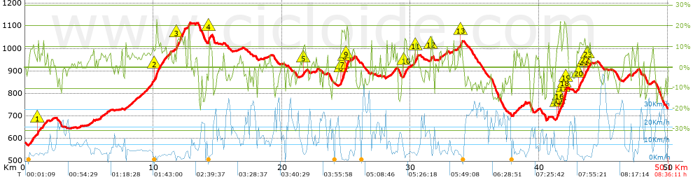
 Day or stage  One day stage  Distance  Climb in  IBP
 Day 1  772668 Caminos Santiago Cantábrico 01. Santander-San Vicente de la Barquera.  77 Km  1405 m  98
 Day 2  772669 Caminos Santiago Cantábrico 02. San Vicente de la Barquera-Cicera.  43 Km  1361 m  109
 Day 3  772670 Caminos Santiago Cantábrico 03. Cicera-Fuente De.  51 Km  2186 m  181
 Day 4  772674 Caminos Santiago Cantábrico 04. Fuente De-Cistierna.  79 Km  1259 m  112
 Day 5  772675 Caminos Santiago Cantábrico 05. Cistierna-León.  65 Km  165 m  28
 Day 6  772676 Caminos Santiago Cantábrico 06. León-Pajares.  66 Km  1738 m  147
 Day 7  772677 Caminos Santiago Cantábrico 07. Pajares-Oviedo.  55 Km  1222 m  113
 Day 8  772678 Caminos Santiago Cantábrico 08. Oviedo-Tineo.  68 Km  2000 m  151
 Day 9  772679 Caminos Santiago Cantábrico 09. Tineo-Grandas de Salime.  61 Km  2175 m  167
 Day 10  772680 Caminos Santiago Cantábrico 10. Grandas de Salime-Cadavo Baleira. (This)  50 Km  1623 m  126
 Day 11  772684 Caminos Santiago Cantábrico 11. Cadavo Baleira-Melide.  79 Km  1614 m  105
 Day 12  772687 Caminos Santiago Cantábrico 12. Melide-Santiago de Compostela.  54 Km  1064 m  74
 Total 12 days  748 Km  17812 m  118 / día

 Height in m      Climb in %      Speed in Km/h      Speed < 2 Km/h


Description of the route


Presence of ramps


 Climbs  Distance  % of the total  Speed  Your speed would be  Time  Your time would be
   15 - 30%  1.621  3.24  2.96  ?  0:32:52  ?
   10 - 15%  3.956  7.89  4.46  ?  0:53:15  ?
   5 - 10%  8.026  16.02  6.48  ?  1:14:18  ?
   1 - 5%  9.857  19.67  8.89  ?  1:06:31  ?
   Total*  23.46 Km  46.82 %  6.2 Km/h  ? Km/h    3:46:56 h  ? h  
 Flat
   1 - -1%  6.713 Km  13.4 %  13.01 Km/h  ? Km/h    0:30:58 h  ? h  
 Descents
   -1 - -5%  7.09  14.15  17.05  ?  0:24:57  ?
   -5 - -10%  7.854  15.67  22  ?  0:21:25  ?
   -10 - -15%  3.333  6.65  19.14  ?  0:10:27  ?
   -15 - -30%  1.663  3.32  22.01  ?  0:04:32  ?
   Total*  19.94 Km  39.79 %  19.5 Km/h  ? Km/h    1:01:21 h  ? h  
* The total has not necessarily coincide with the sum of the partials after correction of errors

How long would it take you?

How long would it take you to cover this route?
There are routes without a valid time information, but with your average stats you can assess the possible duration

zinaztli to cover this route you've need a time of:   5:19:15 h 
If you sign in and have a minimum of two tracks of this same modality, you can know your time for this route, calculated from your stats..


¿Cuanto consumirá tu E-BIKE?

Entra tu E-IBP (formato n,nn)

E-IBP :   X 126 = 


 Detected activity type =  ()
 Penalization due to track conditions: 60 %   ( > 50 % = MTB, < 50 % = RDB)
 Reliability of the track: A   (1623/77/0/-/-/77)
 Correction level applied to the track: 0
DIFFICULTY OF THE ROUTE
IBP = 126 BYC
According to your statistics
 Your time in motion would be: ? h
Your average speed would be: ? Km/h
 

 Total Distance: 50.11 Km
 Analysed distance: 50.11 Km
 Linear distance: 37.79 Km

 Cumulated positive ramps: 1623.22 m  list of points info
 Cumulated negative ramps: 1471.35 m
 Maximum height: 1114.31 m
 Minimum height: 569.72 m
 Climbing Ratio: 6.92 %
 Descent ratio: 7.38 %
 Cumulated postive ramps per Km: 32.39 m
 Cumulated negative ramps per Km: 29.36 m

 Total time: 8:36:11 h
 Time in movement: 5:19:15 h
 According to your statistics
 Your time in motion would be: ? h  
 Stopped time: 3:16:56 h
 Maximum slope filter: ~30 %
 Minimum separation analysed: ~30 m
 Number of points: 1681   (cad. 29.81 m)
 Significant waypoints: 1096   (cad. 45.76 m / 65.2 %)

 Changes in direction per Km: 8.7
 Changes in direction > 5º por Km: 5.71
 Cumulated straight stretches: 9.769 Km
 Straight stretches per Km: 194.95 m
 Penalized slope changes: 14
 Penalized slope changes per Km: 0.279

 Average speed in total: 5.82 Km/h
 Average speed while moving: 9.42 Km/h
 According to your statistics
 Your average speed would be: ? Km/h  
 Maximum sustained speed: 51.81 Km/h


Comments

You can be the first one in commenting this route

 
My comments
:
Add comment  (Registered users)
 
Notify me answers to my comment  Do not notify answers to my comment


Share this route with a friend

Your friend will receive a message with a link to this page:
will see your email and your user name if you do it as registered user.


Write here your name (optional)

E-mail address of your friend(s). You can include various addresses separated by commas

Text or comment (optional) maximum 255 characters long, 255 Available characters

As a non registered users you need to fill-in the captcha text.
  Change image
Type the image characters.
 
 Share with a friend


Visited history

Delete history

Marked routes for review later or compare

My favorites


  Notify anomaly in this route Share in Facebook