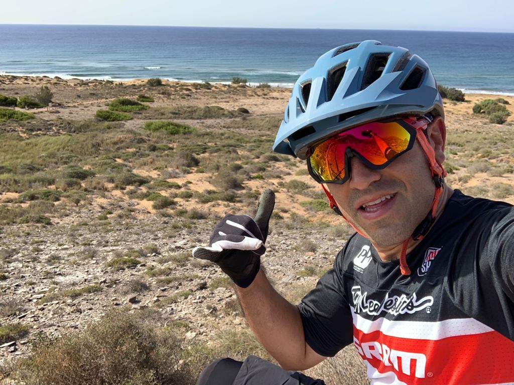
Entrenamiento nocturno

MTB
MTB
Ref..: 771533
Published: 13/07/2019
Performed: 08/07/2019
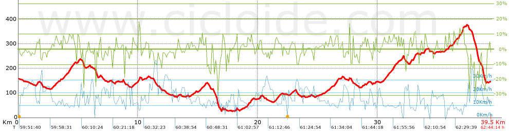
Distance in Km: 39.47
Climb in m: 935
IBP: 66 BYC

galluta
Author: galluta
41 published routes

Add to my Group or Club

 Height in m      Climb in %      Speed in Km/h      Speed < 2 Km/h

Climbs > 5%

Climbs >5% Climbs >10% Climbs >15% Climbs >20% Climbs >25%
 Steep slope of 142 m.   Average slope  Distances  Download as waypoint
1
 Km 1.465  6%  142 m
 Steep slope of 237 m.  Average slope  Distances  Download as waypoint
2
 Km 3.045  6%  237 m
 Steep slope of 107 m.  Average slope  Distances  Download as waypoint
3
 Km 3.466  6%  107 m
 Steep slope of 241 m.  Average slope  Distances  Download as waypoint
4
 Km 3.722  6%  241 m
 Steep slope of 619 m.  Average slope  Distances  Download as waypoint
5
 Km 4.122  7%  619 m
 Steep slope of 173 m.  Average slope  Distances  Download as waypoint
6
 Km 4.933  9%  173 m
 Steep slope of 104 m.  Average slope  Distances  Download as waypoint
7
 Km 5.81  8%  104 m
 Steep slope of 140 m.  Average slope  Distances  Download as waypoint
8
 Km 9.499  7%  140 m
 Steep slope of 169 m.  Average slope  Distances  Download as waypoint
9
 Km 10.011  13%  133 m
10
 Km 10.144  14%  36 m
 Steep slope of 100 m.  Average slope  Distances  Download as waypoint
11
 Km 14.438  5%  100 m
 Steep slope of 109 m.  Average slope  Distances  Download as waypoint
12
 Km 15.137  7%  109 m
 Steep slope of 135 m.  Average slope  Distances  Download as waypoint
13
 Km 15.342  6%  135 m
 Steep slope of 176 m.  Average slope  Distances  Download as waypoint
14
 Km 15.574  8%  176 m
 Steep slope of 107 m.  Average slope  Distances  Download as waypoint
15
 Km 17.005  6%  107 m
 Steep slope of 135 m.  Average slope  Distances  Download as waypoint
16
 Km 18.139  7%  135 m
 Steep slope of 133 m.  Average slope  Distances  Download as waypoint
17
 Km 19.098  8%  133 m
 Steep slope of 144 m.  Average slope  Distances  Download as waypoint
18
 Km 19.372  8%  144 m
 Steep slope of 146 m.  Average slope  Distances  Download as waypoint
19
 Km 20.124  7%  146 m
 Steep slope of 285 m.  Average slope  Distances  Download as waypoint
20
 Km 21.425  6%  285 m
 Steep slope of 343 m.  Average slope  Distances  Download as waypoint
21
 Km 26.383  8%  343 m
 Steep slope of 104 m.  Average slope  Distances  Download as waypoint
22
 Km 26.951  6%  104 m
 Steep slope of 108 m.  Average slope  Distances  Download as waypoint
23
 Km 29.068  5%  108 m
 Steep slope of 319 m.  Average slope  Distances  Download as waypoint
24
 Km 30.479  6%  319 m
 Steep slope of 218 m.  Average slope  Distances  Download as waypoint
25
 Km 30.911  7%  218 m
 Steep slope of 340 m.  Average slope  Distances  Download as waypoint
26
 Km 31.236  7%  340 m
 Steep slope of 207 m.  Average slope  Distances  Download as waypoint
27
 Km 31.93  8%  207 m
 Steep slope of 173 m.  Average slope  Distances  Download as waypoint
28
 Km 32.669  9%  173 m
 Steep slope of 234 m.  Average slope  Distances  Download as waypoint
29
 Km 32.976  7%  70 m
30
 Km 33.046  12%  131 m
31
 Km 33.177  7%  33 m
 Steep slope of 103 m.  Average slope  Distances  Download as waypoint
32
 Km 33.56  6%  103 m
 Steep slope of 132 m.  Average slope  Distances  Download as waypoint
33
 Km 33.898  9%  132 m
 Steep slope of 142 m.  Average slope  Distances  Download as waypoint
34
 Km 35.59  7%  142 m
 Steep slope of 104 m.  Average slope  Distances  Download as waypoint
35
 Km 35.868  7%  104 m
 Steep slope of 274 m.  Average slope  Distances  Download as waypoint
36
 Km 36.307  8%  274 m
 Steep slope of 398 m.  Average slope  Distances  Download as waypoint
37
 Km 36.718  7%  35 m
38
 Km 36.753  12%  98 m
39
 Km 36.85  6%  168 m
40
 Km 37.019  13%  97 m


Description of the route


Presence of ramps


 Climbs  Distance  % of the total  Speed  Your speed would be  Time  Your time would be
   15 - 30%  0.196  0.5  5.27  ?  0:02:14  ?
   10 - 15%  1.044  2.65  7.47  ?  0:08:23  ?
   5 - 10%  6.96  17.64  10.64  ?  0:39:15  ?
   1 - 5%  10.067  25.51  13.27  ?  0:45:31  ?
   Total*  18.267 Km  46.29 %  11.49 Km/h  ? Km/h    1:35:23 h  ? h  
 Flat
   1 - -1%  6.354 Km  16.1 %  17.84 Km/h  ? Km/h    0:21:22 h  ? h  
 Descents
   -1 - -5%  8.768  22.22  22.15  ?  0:23:45  ?
   -5 - -10%  3.532  8.95  20.35  ?  0:10:25  ?
   -10 - -15%  1.03  2.61  15.01  ?  0:04:07  ?
   -15 - -30%  1.514  3.84  12.56  ?  0:07:14  ?
   Total*  14.845 Km  37.61 %  19.57 Km/h  ? Km/h    0:45:31 h  ? h  
* The total has not necessarily coincide with the sum of the partials after correction of errors

How long would it take you?

How long would it take you to cover this route?
There are routes without a valid time information, but with your average stats you can assess the possible duration

galluta to cover this route you've need a time of:   2:42:16 h 
If you sign in and have a minimum of two tracks of this same modality, you can know your time for this route, calculated from your stats..


¿Cuanto consumirá tu E-BIKE?

Entra tu E-IBP (formato n,nn)

E-IBP :   X 66 = 


 Detected activity type =  ()
 Penalization due to track conditions: 76 %   ( > 50 % = MTB, < 50 % = RDB)
 Reliability of the track: C   (936/55/0/-/-/55)
 Correction level applied to the track: 0
DIFFICULTY OF THE ROUTE
IBP = 66 BYC
According to your statistics
 Your time in motion would be: ? h
Your average speed would be: ? Km/h
 

 Total Distance: 39.47 Km
 Analysed distance: 39.47 Km
 Linear distance: 0.13 Km

 Cumulated positive ramps: 935.4 m  list of points info
 Cumulated negative ramps: 941.8 m
 Maximum height: 376.8 m
 Minimum height: 25.4 m
 Climbing Ratio: 5.12 %
 Descent ratio: 6.34 %
 Cumulated postive ramps per Km: 23.7 m
 Cumulated negative ramps per Km: 23.86 m

 Total time: 62:44:14 h
 Time in movement: 2:42:16 h
 According to your statistics
 Your time in motion would be: ? h  
 Stopped time: 60:01:58 h
 Maximum slope filter: ~30 %
 Minimum separation analysed: ~30 m
 Number of points: 3182   (cad. 12.4 m)
 Significant waypoints: 1112   (cad. 35.49 m / 34.95 %)

 Changes in direction per Km: 10.67
 Changes in direction > 5º por Km: 7.88
 Cumulated straight stretches: 6.479 Km
 Straight stretches per Km: 164.15 m
 Penalized slope changes: 9
 Penalized slope changes per Km: 0.228

 Average speed in total: 0.63 Km/h
 Average speed while moving: 14.59 Km/h
 According to your statistics
 Your average speed would be: ? Km/h  
 Maximum sustained speed: 47.05 Km/h


Comments

You can be the first one in commenting this route

 
My comments
:
Add comment  (Registered users)
 
Notify me answers to my comment  Do not notify answers to my comment


Share this route with a friend

Your friend will receive a message with a link to this page:
will see your email and your user name if you do it as registered user.


Write here your name (optional)

E-mail address of your friend(s). You can include various addresses separated by commas

Text or comment (optional) maximum 255 characters long, 255 Available characters

As a non registered users you need to fill-in the captcha text.
  Change image
Type the image characters.
 
 Share with a friend


Visited history

Delete history

Marked routes for review later or compare

My favorites


  Notify anomaly in this route Share in Facebook