Manzanares El Real (Madrid)

MTB
MTB
Ref..: 769054
Published: 11/07/2019
Performed: 10/07/2019
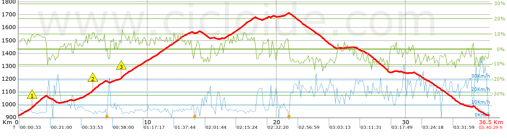
Distance in Km: 36.51
Climb in m: 1030
IBP: 56 BYC

orcinus63
Author: orcinus63
105 published routes

Add to my Group or Club

 Height in m      Climb in %      Speed in Km/h      Speed < 2 Km/h

Climbs > 5%

Climbs >5% Climbs >10% Climbs >15% Climbs >20% Climbs >25%
 Steep slope of 296 m.   Average slope  Distances  Download as waypoint
1
 Km 0.137  6%  296 m
 Steep slope of 1493 m.  Average slope  Distances  Download as waypoint
2
 Km 0.568  6%  457 m
3
 Km 1.026  11%  96 m
4
 Km 1.122  8%  940 m
 Steep slope of 270 m.  Average slope  Distances  Download as waypoint
5
 Km 4.976  6%  270 m
 Steep slope of 872 m.  Average slope  Distances  Download as waypoint
6
 Km 5.44  8%  289 m
7
 Km 5.728  10%  96 m
8
 Km 5.824  9%  487 m
 Steep slope of 281 m.  Average slope  Distances  Download as waypoint
9
 Km 6.407  7%  281 m
 Steep slope of 111 m.  Average slope  Distances  Download as waypoint
10
 Km 7.104  5%  111 m
 Steep slope of 96 m.  Average slope  Distances  Download as waypoint
11
 Km 7.319  7%  96 m
 Steep slope of 746 m.  Average slope  Distances  Download as waypoint
12
 Km 7.801  6%  198 m
13
 Km 7.998  11%  143 m
14
 Km 8.142  8%  405 m
 Steep slope of 591 m.  Average slope  Distances  Download as waypoint
15
 Km 8.675  7%  591 m
 Steep slope of 490 m.  Average slope  Distances  Download as waypoint
16
 Km 9.43  7%  490 m
 Steep slope of 165 m.  Average slope  Distances  Download as waypoint
17
 Km 10.087  6%  165 m
 Steep slope of 919 m.  Average slope  Distances  Download as waypoint
18
 Km 10.35  7%  919 m
 Steep slope of 496 m.  Average slope  Distances  Download as waypoint
19
 Km 11.367  7%  496 m
 Steep slope of 809 m.  Average slope  Distances  Download as waypoint
20
 Km 11.997  7%  809 m
 Steep slope of 134 m.  Average slope  Distances  Download as waypoint
21
 Km 13.005  5%  134 m
 Steep slope of 134 m.  Average slope  Distances  Download as waypoint
22
 Km 13.273  6%  134 m
 Steep slope of 165 m.  Average slope  Distances  Download as waypoint
23
 Km 13.823  7%  165 m
 Steep slope of 333 m.  Average slope  Distances  Download as waypoint
24
 Km 15.963  7%  333 m
 Steep slope of 326 m.  Average slope  Distances  Download as waypoint
25
 Km 16.426  7%  326 m
 Steep slope of 1433 m.  Average slope  Distances  Download as waypoint
26
 Km 16.847  7%  1433 m
 Steep slope of 132 m.  Average slope  Distances  Download as waypoint
27
 Km 18.927  5%  132 m
 Steep slope of 170 m.  Average slope  Distances  Download as waypoint
28
 Km 19.225  6%  170 m
 Steep slope of 99 m.  Average slope  Distances  Download as waypoint
29
 Km 19.607  7%  99 m
 Steep slope of 263 m.  Average slope  Distances  Download as waypoint
30
 Km 20.633  6%  263 m


Description of the route


Presence of ramps


 Climbs  Distance  % of the total  Speed  Your speed would be  Time  Your time would be
   15 - 30%  0  0  0  ?  0:00:00  ?
   10 - 15%  0.779  2.13  5.56  ?  0:08:24  ?
   5 - 10%  10.509  28.79  7.1  ?  1:28:50  ?
   1 - 5%  6.346  17.38  10.14  ?  0:37:34  ?
   Total*  17.635 Km  48.3 %  7.85 Km/h  ? Km/h    2:14:48 h  ? h  
 Flat
   1 - -1%  2.399 Km  6.57 %  17.07 Km/h  ? Km/h    0:08:26 h  ? h  
 Descents
   -1 - -5%  5.563  15.24  18.09  ?  0:18:27  ?
   -5 - -10%  9.508  26.04  22.61  ?  0:25:14  ?
   -10 - -15%  1.325  3.63  18.14  ?  0:04:23  ?
   -15 - -30%  0.078  0.21  28.06  ?  0:00:10  ?
   Total*  16.473 Km  45.12 %  20.49 Km/h  ? Km/h    0:48:14 h  ? h  
* The total has not necessarily coincide with the sum of the partials after correction of errors

How long would it take you?

How long would it take you to cover this route?
There are routes without a valid time information, but with your average stats you can assess the possible duration

orcinus63 to cover this route you've need a time of:   3:11:28 h 
If you sign in and have a minimum of two tracks of this same modality, you can know your time for this route, calculated from your stats..


¿Cuanto consumirá tu E-BIKE?

Entra tu E-IBP (formato n,nn)

E-IBP :   X 56 = 


 Detected activity type =  ()
 Penalization due to track conditions: 54 %   ( > 50 % = MTB, < 50 % = RDB)
 Reliability of the track: A   (1029/85/0/-/-/85)
 Correction level applied to the track: 0
DIFFICULTY OF THE ROUTE
IBP = 56 BYC
According to your statistics
 Your time in motion would be: ? h
Your average speed would be: ? Km/h
 

 Total Distance: 36.51 Km
 Analysed distance: 36.51 Km
 Linear distance: 0.08 Km

 Cumulated positive ramps: 1029.8 m  list of points info
 Cumulated negative ramps: 1029.6 m
 Maximum height: 1713.4 m
 Minimum height: 914.4 m
 Climbing Ratio: 5.84 %
 Descent ratio: 6.25 %
 Cumulated postive ramps per Km: 28.21 m
 Cumulated negative ramps per Km: 28.2 m

 Total time: 3:40:29 h
 Time in movement: 3:11:28 h
 According to your statistics
 Your time in motion would be: ? h  
 Stopped time: 0:29:01 h
 Maximum slope filter: ~30 %
 Minimum separation analysed: ~30 m
 Number of points: 2958   (cad. 12.34 m)
 Significant waypoints: 1044   (cad. 34.97 m / 35.29 %)

 Changes in direction per Km: 13.04
 Changes in direction > 5º por Km: 9.26
 Cumulated straight stretches: 5.239 Km
 Straight stretches per Km: 143.49 m
 Penalized slope changes: 9
 Penalized slope changes per Km: 0.247

 Average speed in total: 9.93 Km/h
 Average speed while moving: 11.44 Km/h
 According to your statistics
 Your average speed would be: ? Km/h  
 Maximum sustained speed: 55.87 Km/h


Comments

You can be the first one in commenting this route

 
My comments
:
Add comment  (Registered users)
 
Notify me answers to my comment  Do not notify answers to my comment


Share this route with a friend

Your friend will receive a message with a link to this page:
will see your email and your user name if you do it as registered user.


Write here your name (optional)

E-mail address of your friend(s). You can include various addresses separated by commas

Text or comment (optional) maximum 255 characters long, 255 Available characters

As a non registered users you need to fill-in the captcha text.
  Change image
Type the image characters.
 
 Share with a friend


Visited history

Delete history

Marked routes for review later or compare

My favorites


  Notify anomaly in this route Share in Facebook