Trail Tozal de Guara

Running
Running
Ref..: 724563
Published: 30/05/2019
Performed: 27/05/2019
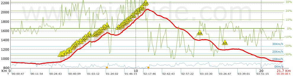
Distance in Km: 21.67
Climb in m: 1367
IBP: 298 RNG


 Height in m      Climb in %      Speed in Km/h      Speed < 2 Km/h

Climbs > 5%

Climbs >5% Climbs >10% Climbs >15% Climbs >20% Climbs >25%
 Steep slope of 339 m.   Average slope  Distances  Download as waypoint
1
 Km 3.987  6%  32 m
2
 Km 4.019  21%  100 m
3
 Km 4.119  8%  140 m
4
 Km 4.259  20%  67 m
 Steep slope of 939 m.  Average slope  Distances  Download as waypoint
5
 Km 4.436  16%  32 m
6
 Km 4.468  18%  112 m
7
 Km 4.581  19%  108 m
8
 Km 4.688  22%  144 m
9
 Km 4.832  29%  137 m
10
 Km 4.97  32%  68 m
11
 Km 5.037  19%  34 m
12
 Km 5.071  26%  138 m
13
 Km 5.209  18%  100 m
14
 Km 5.309  26%  66 m
 Steep slope of 836 m.  Average slope  Distances  Download as waypoint
15
 Km 5.475  9%  32 m
16
 Km 5.507  16%  74 m
17
 Km 5.581  19%  135 m
18
 Km 5.716  21%  101 m
19
 Km 5.817  26%  69 m
20
 Km 5.886  23%  97 m
21
 Km 5.983  19%  165 m
22
 Km 6.148  26%  97 m
23
 Km 6.245  24%  33 m
24
 Km 6.278  18%  33 m
 Steep slope of 1017 m.  Average slope  Distances  Download as waypoint
25
 Km 6.66  15%  34 m
26
 Km 6.694  11%  100 m
27
 Km 6.794  19%  69 m
28
 Km 6.863  18%  100 m
29
 Km 6.963  22%  97 m
30
 Km 7.06  29%  136 m
31
 Km 7.195  22%  142 m
32
 Km 7.337  13%  105 m
33
 Km 7.442  18%  197 m
34
 Km 7.639  16%  37 m
 Steep slope of 1116 m.  Average slope  Distances  Download as waypoint
35
 Km 8.548  15%  34 m
36
 Km 8.582  18%  138 m
37
 Km 8.72  24%  102 m
38
 Km 8.822  20%  94 m
39
 Km 8.916  26%  99 m
40
 Km 9.015  21%  33 m
41
 Km 9.048  7%  69 m
42
 Km 9.116  18%  33 m
43
 Km 9.15  38%  140 m
44
 Km 9.29  16%  32 m
45
 Km 9.322  11%  135 m
46
 Km 9.457  22%  36 m
47
 Km 9.493  36%  137 m
48
 Km 9.629  26%  34 m
 Steep slope of 546 m.  Average slope  Distances  Download as waypoint
49
 Km 9.733  12%  31 m
50
 Km 9.764  34%  205 m
51
 Km 9.969  21%  72 m
52
 Km 10.042  18%  67 m
53
 Km 10.109  13%  98 m
54
 Km 10.207  36%  73 m
 Steep slope of 547 m.  Average slope  Distances  Download as waypoint
55
 Km 10.39  26%  96 m
56
 Km 10.487  40%  175 m
57
 Km 10.662  32%  70 m
58
 Km 10.732  12%  206 m
 Steep slope of 173 m.  Average slope  Distances  Download as waypoint
59
 Km 15.022  5%  173 m
 Steep slope of 100 m.  Average slope  Distances  Download as waypoint
60
 Km 17.05  8%  100 m


Description of the route


Presence of ramps


 Climbs  Distance  % of the total  Speed  Your speed would be  Time  Your time would be
   15 - 30%  3.309  15.27  3.84  ?  0:51:44  ?
   10 - 15%  0.788  3.64  4.35  ?  0:10:52  ?
   5 - 10%  1.81  8.35  6.28  ?  0:17:17  ?
   1 - 5%  1.802  8.31  7.12  ?  0:15:11  ?
   Total*  8.666 Km  40 %  4.31 Km/h  ? Km/h    2:00:32 h  ? h  
 Flat
   1 - -1%  2.513 Km  11.6 %  7.06 Km/h  ? Km/h    0:21:22 h  ? h  
 Descents
   -1 - -5%  2.259  10.42  7.92  ?  0:17:07  ?
   -5 - -10%  2.895  13.36  7.53  ?  0:23:05  ?
   -10 - -15%  1.536  7.09  6.57  ?  0:14:02  ?
   -15 - -30%  3.186  14.7  5.77  ?  0:33:06  ?
   Total*  10.488 Km  48.41 %  6.57 Km/h  ? Km/h    1:35:45 h  ? h  
* The total has not necessarily coincide with the sum of the partials after correction of errors

How long would it take you?

How long would it take you to cover this route?
There are routes without a valid time information, but with your average stats you can assess the possible duration

Roberto Rodrigo Perez to cover this route you've need a time of:   3:57:39 h 
If you sign in and have a minimum of two tracks of this same modality, you can know your time for this route, calculated from your stats..


 Detected activity type =  ()
 Penalization due to track conditions: 0 %   ( > 50 % = MTB, < 50 % = RDB)
 Reliability of the track: A   (1367/80/0/-/-/80)
 Correction level applied to the track: 0
DIFFICULTY OF THE ROUTE
IBP = 298 RNG
According to your statistics
 Your time in motion would be: ? h
Your average speed would be: ? Km/h
 

 Total Distance: 21.67 Km
 Analysed distance: 21.67 Km
 Linear distance: 0.03 Km

 Cumulated positive ramps: 1367 m  list of points info
 Cumulated negative ramps: 1352 m
 Maximum height: 2074 m
 Minimum height: 889 m
 Climbing Ratio: 15.77 %
 Descent ratio: 12.89 %
 Cumulated postive ramps per Km: 63.08 m
 Cumulated negative ramps per Km: 62.39 m

 Total time: 4:09:08 h
 Time in movement: 3:57:39 h
 According to your statistics
 Your time in motion would be: ? h  
 Stopped time: 0:11:29 h
 Maximum slope filter: ~55 %
 Minimum separation analysed: ~30 m
 Number of points: 1909   (cad. 11.35 m)
 Significant waypoints: 635   (cad. 34.12 m / 33.26 %)

 Changes in direction per Km: 13.11
 Changes in direction > 5º por Km: 10.61
 Cumulated straight stretches: 2.891 Km
 Straight stretches per Km: 133.41 m
 Penalized slope changes: 9
 Penalized slope changes per Km: 0.415

 Average speed in total: 5.22 Km/h
 Average speed while moving: 5.47 Km/h
 According to your statistics
 Your average speed would be: ? Km/h  
 Maximum sustained speed: 11.02 Km/h


Comments

You can be the first one in commenting this route

 
My comments
:
Add comment  (Registered users)
 
Notify me answers to my comment  Do not notify answers to my comment


Share this route with a friend

Your friend will receive a message with a link to this page:
will see your email and your user name if you do it as registered user.


Write here your name (optional)

E-mail address of your friend(s). You can include various addresses separated by commas

Text or comment (optional) maximum 255 characters long, 255 Available characters

As a non registered users you need to fill-in the captcha text.
  Change image
Type the image characters.
 
 Share with a friend


Visited history

Delete history

Marked routes for review later or compare

My favorites


  Notify anomaly in this route Share in Facebook