20190514 Camino a Oporto-Hinojosa del Duero

Road
Ref..: 708147
Published: 14/05/2019
Performed: 14/05/2019
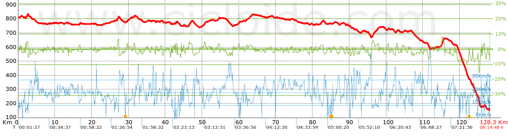
Distance in Km: 128.31
Climb in m: 792
IBP: 79 BYC
 View on STRAVA
Near ...
Salamanca
Salamanca

This route belongs to a multi-day journey 6 days documented with 6 independent routes
You can download the tracks of this multi-day route from each of the associated stages .| Day or stage | One day stage | Distance | Climb in | IBP |
| Day 1 | 705541 20190512 Camino a Oporto-Ar�valo | 81 Km | 674 m | 42 |
| Day 2 | 706858 20190513 Camino a Oporto-Salamanca | 93 Km | 227 m | 37 |
| Day 3 | 708147 20190514 Camino a Oporto-Hinojosa del Duero (This) | 128 Km | 756 m | 78 |
| Day 4 | 709231 21090515 Camino a Oporto-Pocinho/Pinhao | 49 Km | 1261 m | 77 |
| Day 5 | 710260 20190516 Camino a Oporto-Cinf_es | 78 Km | 1261 m | 83 |
| Day 6 | 711328 20190517 Camino a Oporto-Oporto | 72 Km | 1082 m | 81 |
| Total 6 days | 501 Km | 5261 m | 66 / d�a |
Description of the route

Presence of ramps
| Climbs | Distance | % of the total | Speed | Your speed would be | Time | Your time would be | |
| 15 - 30% | 0 | 0 | 0 | ? | 0:00:00 | ? | |
| 10 - 15% | 0.043 | 0.03 | 0 | ? | 0:00:00 | ? | |
| 5 - 10% | 1.751 | 1.36 | 8.29 | ? | 0:12:41 | ? | |
| 1 - 5% | 31.406 | 24.48 | 13.71 | ? | 2:17:25 | ? | |
| Total* | 33.2 Km | 25.87 % | 13.27 Km/h | ?
Km/h  |
2:30:06 h | ? h |
|
| Flat | |||||||
| 1 - -1% | 47.121 Km | 36.72 % | 18.92 Km/h | ?
Km/h |
2:29:27 h | ? h |
|
| Descents | |||||||
| -1 - -5% | 41.324 | 32.21 | 21.79 | ? | 1:53:47 | ? | |
| -5 - -10% | 6.375 | 4.97 | 17.82 | ? | 0:21:28 | ? | |
| -10 - -15% | 0.073 | 0.06 | 18.9 | ? | 0:00:14 | ? | |
| -15 - -30% | 0.246 | 0.19 | 10.2 | ? | 0:01:27 | ? | |
| Total* | 48.02 Km | 37.42 % | 21.04 Km/h | ?
Km/h |
2:16:56 h | ? h |
|
How long would it take you?
 |
|
�Cuanto consumir� tu E-BIKE?
Entra tu E-IBP (formato n,nn)
| Detected activity type = () |
| Penalization due to track conditions: 23 % ( > 50 % = MTB, < 50 % = RDB) |
|
|
Correction level applied to the track:
3
 See analyis without corrections See analyis without corrections
|
|
|
| DIFFICULTY OF THE ROUTE |
IBP = 79 BYC |
| According to your statistics Your time in motion would be: ? h |
| Your average speed would be:
? Km/h |
| Total Distance: 128.32 Km |
| Analysed distance: 128.32 Km |
| Linear distance: 96.1 Km |
| Cumulated positive ramps: 791.92 m |
list of points info |
| Cumulated negative ramps: 1425.25 m | |
| Maximum height: 834.3 m | |
| Minimum height: 149.64 m | |
| Climbing Ratio: 2.39 % | |
| Descent ratio: 2.97 % | |
| Cumulated postive ramps per Km: 6.17 m | |
| Cumulated negative ramps per Km: 11.11 m | |
| Total time: 8:14:48 h |
| Time in movement: 7:16:29 h |
| According to your statistics Your time in motion would be: ? h
|
| Stopped time: 0:58:19 h |
| Maximum slope filter: ~30 % |
| Minimum separation analysed: ~30 m |
| Number of points: 9795 (cad. 13.1 m) |
| Significant waypoints: 3551 (cad. 36.15 m / 36.25 %) |
| Changes in direction per Km: 13.67 |
| Changes in direction > 5� por Km: 4.33 |
| Cumulated straight stretches: 54.346 Km |
| Straight stretches per Km: 423.52 m |
| Penalized slope changes: 12 |
| Penalized slope changes per Km: 0.094 |
| Average speed in total: 15.56 Km/h |
| Average speed while moving: 17.64 Km/h |
| According to your statistics Your average speed would be: ? Km/h
|
| Maximum sustained speed: 56.63 Km/h |


