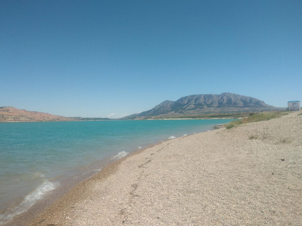
Playa de Freila (Granada)

Road
Road
Ref..: 699953
Published: 07/05/2019
Performed: 04/05/2019
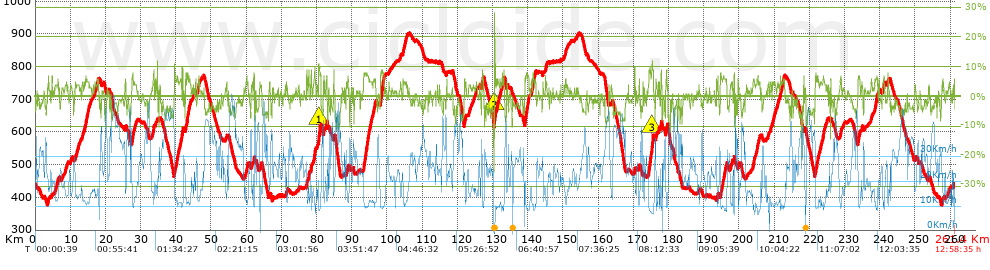
Distance in Km: 261.41
Climb in m: 4012
IBP: 287 BYC


 Height in m      Climb in %      Speed in Km/h      Speed < 2 Km/h

Climbs > 5%

Climbs >5% Climbs >10% Climbs >15% Climbs >20% Climbs >25%
 Steep slope of 143 m.   Average slope  Distances  Download as waypoint
1
 Km 3.713  8%  143 m
 Steep slope of 449 m.  Average slope  Distances  Download as waypoint
2
 Km 14.275  6%  449 m
 Steep slope of 262 m.  Average slope  Distances  Download as waypoint
3
 Km 14.952  6%  262 m
 Steep slope of 158 m.  Average slope  Distances  Download as waypoint
4
 Km 17.593  6%  158 m
 Steep slope of 544 m.  Average slope  Distances  Download as waypoint
5
 Km 27.482  6%  544 m
 Steep slope of 180 m.  Average slope  Distances  Download as waypoint
6
 Km 33.622  8%  180 m
 Steep slope of 180 m.  Average slope  Distances  Download as waypoint
7
 Km 39.546  8%  180 m
 Steep slope of 680 m.  Average slope  Distances  Download as waypoint
8
 Km 40.122  6%  680 m
 Steep slope of 98 m.  Average slope  Distances  Download as waypoint
9
 Km 40.93  5%  98 m
 Steep slope of 232 m.  Average slope  Distances  Download as waypoint
10
 Km 41.347  6%  232 m
 Steep slope of 339 m.  Average slope  Distances  Download as waypoint
11
 Km 41.686  9%  339 m
 Steep slope of 213 m.  Average slope  Distances  Download as waypoint
12
 Km 42.809  7%  213 m
 Steep slope of 759 m.  Average slope  Distances  Download as waypoint
13
 Km 43.13  7%  759 m
 Steep slope of 247 m.  Average slope  Distances  Download as waypoint
14
 Km 46.152  6%  247 m
 Steep slope of 101 m.  Average slope  Distances  Download as waypoint
15
 Km 46.499  6%  101 m
 Steep slope of 393 m.  Average slope  Distances  Download as waypoint
16
 Km 60.052  6%  393 m
 Steep slope of 108 m.  Average slope  Distances  Download as waypoint
17
 Km 61.671  6%  108 m
 Steep slope of 219 m.  Average slope  Distances  Download as waypoint
18
 Km 62.081  8%  219 m
 Steep slope of 91 m.  Average slope  Distances  Download as waypoint
19
 Km 66.562  5%  91 m
 Steep slope of 269 m.  Average slope  Distances  Download as waypoint
20
 Km 77.063  7%  269 m
 Steep slope of 249 m.  Average slope  Distances  Download as waypoint
21
 Km 77.645  7%  249 m
 Steep slope of 244 m.  Average slope  Distances  Download as waypoint
22
 Km 78.323  8%  244 m
 Steep slope of 392 m.  Average slope  Distances  Download as waypoint
23
 Km 79.294  7%  392 m
 Steep slope of 706 m.  Average slope  Distances  Download as waypoint
24
 Km 80.507  10%  35 m
25
 Km 80.542  11%  159 m
26
 Km 80.702  8%  512 m
 Steep slope of 194 m.  Average slope  Distances  Download as waypoint
27
 Km 81.951  6%  194 m
 Steep slope of 287 m.  Average slope  Distances  Download as waypoint
28
 Km 82.63  6%  287 m
 Steep slope of 136 m.  Average slope  Distances  Download as waypoint
29
 Km 88.795  6%  136 m
 Steep slope of 1609 m.  Average slope  Distances  Download as waypoint
30
 Km 93.334  7%  1609 m
 Steep slope of 203 m.  Average slope  Distances  Download as waypoint
31
 Km 95.042  5%  203 m
 Steep slope of 166 m.  Average slope  Distances  Download as waypoint
32
 Km 95.349  5%  166 m
 Steep slope of 135 m.  Average slope  Distances  Download as waypoint
33
 Km 95.613  5%  135 m
 Steep slope of 409 m.  Average slope  Distances  Download as waypoint
34
 Km 96.056  5%  409 m
 Steep slope of 159 m.  Average slope  Distances  Download as waypoint
35
 Km 96.575  6%  159 m
 Steep slope of 1077 m.  Average slope  Distances  Download as waypoint
36
 Km 98.089  8%  1077 m
 Steep slope of 175 m.  Average slope  Distances  Download as waypoint
37
 Km 104.499  5%  175 m
 Steep slope of 107 m.  Average slope  Distances  Download as waypoint
38
 Km 104.913  5%  107 m
 Steep slope of 103 m.  Average slope  Distances  Download as waypoint
39
 Km 116.868  6%  103 m
 Steep slope of 202 m.  Average slope  Distances  Download as waypoint
40
 Km 121.947  7%  202 m
 Steep slope of 169 m.  Average slope  Distances  Download as waypoint
41
 Km 122.258  6%  169 m
 Steep slope of 365 m.  Average slope  Distances  Download as waypoint
42
 Km 126.959  7%  365 m
 Steep slope of 312 m.  Average slope  Distances  Download as waypoint
43
 Km 130.463  6%  32 m
44
 Km 130.496  16%  98 m
45
 Km 130.594  10%  182 m
 Steep slope of 188 m.  Average slope  Distances  Download as waypoint
46
 Km 131.38  6%  188 m
 Steep slope of 171 m.  Average slope  Distances  Download as waypoint
47
 Km 131.987  5%  171 m
 Steep slope of 135 m.  Average slope  Distances  Download as waypoint
48
 Km 133.112  9%  135 m
 Steep slope of 1119 m.  Average slope  Distances  Download as waypoint
49
 Km 139.139  8%  1119 m
 Steep slope of 146 m.  Average slope  Distances  Download as waypoint
50
 Km 141.051  6%  146 m
 Steep slope of 284 m.  Average slope  Distances  Download as waypoint
51
 Km 141.369  8%  284 m
 Steep slope of 201 m.  Average slope  Distances  Download as waypoint
52
 Km 142.036  6%  201 m
 Steep slope of 109 m.  Average slope  Distances  Download as waypoint
53
 Km 144.978  6%  109 m
 Steep slope of 178 m.  Average slope  Distances  Download as waypoint
54
 Km 150.659  6%  178 m
 Steep slope of 190 m.  Average slope  Distances  Download as waypoint
55
 Km 170.318  9%  190 m
 Steep slope of 184 m.  Average slope  Distances  Download as waypoint
56
 Km 171.551  7%  184 m
 Steep slope of 1483 m.  Average slope  Distances  Download as waypoint
57
 Km 174.265  8%  1042 m
58
 Km 175.307  10%  115 m
59
 Km 175.422  9%  326 m
 Steep slope of 105 m.  Average slope  Distances  Download as waypoint
60
 Km 176.331  5%  105 m
 Steep slope of 181 m.  Average slope  Distances  Download as waypoint
61
 Km 177.166  6%  181 m
 Steep slope of 271 m.  Average slope  Distances  Download as waypoint
62
 Km 177.747  8%  271 m
 Steep slope of 336 m.  Average slope  Distances  Download as waypoint
63
 Km 179.224  6%  336 m
 Steep slope of 135 m.  Average slope  Distances  Download as waypoint
64
 Km 193.874  7%  135 m
 Steep slope of 372 m.  Average slope  Distances  Download as waypoint
65
 Km 194.713  6%  372 m
 Steep slope of 1199 m.  Average slope  Distances  Download as waypoint
66
 Km 195.225  6%  1199 m
 Steep slope of 142 m.  Average slope  Distances  Download as waypoint
67
 Km 198.524  8%  142 m
 Steep slope of 111 m.  Average slope  Distances  Download as waypoint
68
 Km 199.725  6%  111 m
 Steep slope of 320 m.  Average slope  Distances  Download as waypoint
69
 Km 204.011  6%  320 m
 Steep slope of 340 m.  Average slope  Distances  Download as waypoint
70
 Km 205.079  6%  340 m
 Steep slope of 96 m.  Average slope  Distances  Download as waypoint
71
 Km 209.429  5%  96 m
 Steep slope of 147 m.  Average slope  Distances  Download as waypoint
72
 Km 211.686  6%  147 m
 Steep slope of 200 m.  Average slope  Distances  Download as waypoint
73
 Km 212.061  5%  200 m
 Steep slope of 219 m.  Average slope  Distances  Download as waypoint
74
 Km 212.488  5%  219 m
 Steep slope of 100 m.  Average slope  Distances  Download as waypoint
75
 Km 218.379  8%  100 m
 Steep slope of 858 m.  Average slope  Distances  Download as waypoint
76
 Km 221.606  6%  858 m
 Steep slope of 224 m.  Average slope  Distances  Download as waypoint
77
 Km 223.161  6%  224 m
 Steep slope of 376 m.  Average slope  Distances  Download as waypoint
78
 Km 223.811  6%  376 m
 Steep slope of 304 m.  Average slope  Distances  Download as waypoint
79
 Km 228.731  6%  304 m
 Steep slope of 527 m.  Average slope  Distances  Download as waypoint
80
 Km 233.822  6%  527 m
 Steep slope of 142 m.  Average slope  Distances  Download as waypoint
81
 Km 237.553  5%  142 m
 Steep slope of 805 m.  Average slope  Distances  Download as waypoint
82
 Km 238.557  6%  805 m
 Steep slope of 221 m.  Average slope  Distances  Download as waypoint
83
 Km 241.058  6%  221 m
 Steep slope of 168 m.  Average slope  Distances  Download as waypoint
84
 Km 242.278  7%  168 m
 Steep slope of 108 m.  Average slope  Distances  Download as waypoint
85
 Km 257.87  6%  108 m
 Steep slope of 101 m.  Average slope  Distances  Download as waypoint
86
 Km 261.095  6%  101 m


Description of the route


Presence of ramps


 Climbs  Distance  % of the total  Speed  Your speed would be  Time  Your time would be
   15 - 30%  0.176  0.07  10.38  ?  0:01:01  ?
   10 - 15%  0.976  0.37  10.98  ?  0:05:20  ?
   5 - 10%  27.81  10.64  12.17  ?  2:17:04  ?
   1 - 5%  71.308  27.28  16.15  ?  4:24:51  ?
   Total*  100.27 Km  38.36 %  14.74 Km/h  ? Km/h    6:48:16 h  ? h  
 Flat
   1 - -1%  61.184 Km  23.41 %  23.59 Km/h  ? Km/h    2:35:39 h  ? h  
 Descents
   -1 - -5%  71.115  27.2  30.73  ?  2:18:51  ?
   -5 - -10%  27.577  10.55  37.63  ?  0:43:58  ?
   -10 - -15%  1.1  0.42  27.5  ?  0:02:24  ?
   -15 - -30%  0.16  0.06  9.15  ?  0:01:03  ?
   Total*  99.952 Km  38.24 %  32.2 Km/h  ? Km/h    3:06:16 h  ? h  
* The total has not necessarily coincide with the sum of the partials after correction of errors

How long would it take you?

How long would it take you to cover this route?
There are routes without a valid time information, but with your average stats you can assess the possible duration

Francisco_Javier_Alcázar_Martínez to cover this route you've need a time of:   12:30:11 h 
If you sign in and have a minimum of two tracks of this same modality, you can know your time for this route, calculated from your stats..


¿Cuanto consumirá tu E-BIKE?

Entra tu E-IBP (formato n,nn)

E-IBP :   X 287 = 


 Detected activity type =  ()
 Penalization due to track conditions: 31 %   ( > 50 % = MTB, < 50 % = RDB)
 Reliability of the track: A   (4011/79/0/-/-/79)
 Correction level applied to the track: 0
DIFFICULTY OF THE ROUTE
IBP = 287 BYC
According to your statistics
 Your time in motion would be: ? h
Your average speed would be: ? Km/h
 

 Total Distance: 261.41 Km
 Analysed distance: 261.41 Km
 Linear distance: 0.09 Km

 Cumulated positive ramps: 4011.6 m  list of points info
 Cumulated negative ramps: 4005.6 m
 Maximum height: 902.5 m
 Minimum height: 377 m
 Climbing Ratio: 4 %
 Descent ratio: 4.01 %
 Cumulated postive ramps per Km: 15.35 m
 Cumulated negative ramps per Km: 15.32 m

 Total time: 12:58:35 h
 Time in movement: 12:30:11 h
 According to your statistics
 Your time in motion would be: ? h  
 Stopped time: 0:28:24 h
 Maximum slope filter: ~30 %
 Minimum separation analysed: ~30 m
 Number of points: 20059   (cad. 13.03 m)
 Significant waypoints: 7371   (cad. 35.46 m / 36.75 %)

 Changes in direction per Km: 8.51
 Changes in direction > 5º por Km: 2.56
 Cumulated straight stretches: 128.372 Km
 Straight stretches per Km: 491.08 m
 Penalized slope changes: 41
 Penalized slope changes per Km: 0.157

 Average speed in total: 20.14 Km/h
 Average speed while moving: 20.91 Km/h
 According to your statistics
 Your average speed would be: ? Km/h  
 Maximum sustained speed: 56.63 Km/h


Comments

You can be the first one in commenting this route

 
My comments
:
Add comment  (Registered users)
 
Notify me answers to my comment  Do not notify answers to my comment


Share this route with a friend

Your friend will receive a message with a link to this page:
will see your email and your user name if you do it as registered user.


Write here your name (optional)

E-mail address of your friend(s). You can include various addresses separated by commas

Text or comment (optional) maximum 255 characters long, 255 Available characters

As a non registered users you need to fill-in the captcha text.
  Change image
Type the image characters.
 
 Share with a friend


Visited history

Delete history

Marked routes for review later or compare

My favorites


  Notify anomaly in this route Share in Facebook