Ride: #VueltalafincademitioEPIC

MTB
MTB
Ref..: 699428
Published: 06/05/2019
Performed: 04/05/2019
Distance in Km: 70.71
Climb in m: 2376
IBP: 188 BYC

Alejandro_Andrade_M
143 published routes

Add to my Group or Club

 Height in m      Climb in %      Speed in Km/h      Speed < 2 Km/h

Climbs > 5%

Climbs >5% Climbs >10% Climbs >15% Climbs >20% Climbs >25%
 Steep slope of 475 m.   Average slope  Distances  Download as waypoint
1
 Km 1.549  7%  407 m
2
 Km 1.956  11%  37 m
3
 Km 1.992  15%  31 m
 Steep slope of 1565 m.  Average slope  Distances  Download as waypoint
4
 Km 2.416  8%  811 m
5
 Km 3.227  11%  430 m
6
 Km 3.658  17%  188 m
7
 Km 3.846  16%  30 m
8
 Km 3.876  9%  106 m
 Steep slope of 242 m.  Average slope  Distances  Download as waypoint
9
 Km 4.292  8%  242 m
 Steep slope of 210 m.  Average slope  Distances  Download as waypoint
10
 Km 4.857  8%  210 m
 Steep slope of 314 m.  Average slope  Distances  Download as waypoint
11
 Km 5.439  10%  314 m
 Steep slope of 245 m.  Average slope  Distances  Download as waypoint
12
 Km 6.376  10%  245 m
 Steep slope of 359 m.  Average slope  Distances  Download as waypoint
13
 Km 6.954  8%  359 m
 Steep slope of 159 m.  Average slope  Distances  Download as waypoint
14
 Km 8.688  5%  159 m
 Steep slope of 260 m.  Average slope  Distances  Download as waypoint
15
 Km 9.176  6%  260 m
 Steep slope of 130 m.  Average slope  Distances  Download as waypoint
16
 Km 10.89  9%  130 m
 Steep slope of 177 m.  Average slope  Distances  Download as waypoint
17
 Km 12.028  14%  143 m
18
 Km 12.171  7%  34 m
 Steep slope of 117 m.  Average slope  Distances  Download as waypoint
19
 Km 12.379  7%  117 m
 Steep slope of 411 m.  Average slope  Distances  Download as waypoint
20
 Km 13.287  8%  411 m
 Steep slope of 118 m.  Average slope  Distances  Download as waypoint
21
 Km 14.136  8%  118 m
 Steep slope of 327 m.  Average slope  Distances  Download as waypoint
22
 Km 14.518  11%  236 m
23
 Km 14.754  6%  91 m
 Steep slope of 151 m.  Average slope  Distances  Download as waypoint
24
 Km 30.939  5%  151 m
 Steep slope of 102 m.  Average slope  Distances  Download as waypoint
25
 Km 33.804  6%  102 m
 Steep slope of 209 m.  Average slope  Distances  Download as waypoint
26
 Km 34.494  7%  209 m
 Steep slope of 285 m.  Average slope  Distances  Download as waypoint
27
 Km 35.874  6%  285 m
 Steep slope of 355 m.  Average slope  Distances  Download as waypoint
28
 Km 36.267  7%  355 m
 Steep slope of 339 m.  Average slope  Distances  Download as waypoint
29
 Km 38.247  7%  339 m
 Steep slope of 175 m.  Average slope  Distances  Download as waypoint
30
 Km 42.83  13%  175 m
 Steep slope of 186 m.  Average slope  Distances  Download as waypoint
31
 Km 43.637  9%  39 m
32
 Km 43.676  17%  102 m
33
 Km 43.779  12%  45 m
 Steep slope of 269 m.  Average slope  Distances  Download as waypoint
34
 Km 45.224  5%  269 m
 Steep slope of 1512 m.  Average slope  Distances  Download as waypoint
35
 Km 46.087  7%  40 m
36
 Km 46.127  16%  519 m
37
 Km 46.646  11%  485 m
38
 Km 47.131  9%  255 m
39
 Km 47.385  12%  35 m
40
 Km 47.42  20%  145 m
41
 Km 47.565  10%  33 m
 Steep slope of 1029 m.  Average slope  Distances  Download as waypoint
42
 Km 47.746  7%  286 m
43
 Km 48.032  12%  623 m
44
 Km 48.655  6%  120 m
 Steep slope of 1359 m.  Average slope  Distances  Download as waypoint
45
 Km 48.963  7%  263 m
46
 Km 49.226  12%  284 m
47
 Km 49.51  15%  245 m
48
 Km 49.755  13%  290 m
49
 Km 50.045  9%  277 m
 Steep slope of 1193 m.  Average slope  Distances  Download as waypoint
50
 Km 50.741  13%  505 m
51
 Km 51.246  17%  538 m
52
 Km 51.784  14%  150 m
 Steep slope of 420 m.  Average slope  Distances  Download as waypoint
53
 Km 54.077  7%  32 m
54
 Km 54.109  16%  108 m
55
 Km 54.217  9%  280 m
 Steep slope of 2769 m.  Average slope  Distances  Download as waypoint
56
 Km 55.268  12%  920 m
57
 Km 56.188  9%  615 m
58
 Km 56.803  11%  265 m
59
 Km 57.068  9%  969 m
 Steep slope of 119 m.  Average slope  Distances  Download as waypoint
60
 Km 58.546  8%  119 m
 Steep slope of 350 m.  Average slope  Distances  Download as waypoint
61
 Km 58.911  9%  350 m
 Steep slope of 413 m.  Average slope  Distances  Download as waypoint
62
 Km 59.418  5%  31 m
63
 Km 59.449  13%  382 m
 Steep slope of 841 m.  Average slope  Distances  Download as waypoint
64
 Km 60.028  11%  247 m
65
 Km 60.275  6%  594 m
 Steep slope of 226 m.  Average slope  Distances  Download as waypoint
66
 Km 61.095  8%  226 m
 Steep slope of 106 m.  Average slope  Distances  Download as waypoint
67
 Km 61.921  7%  106 m
 Steep slope of 717 m.  Average slope  Distances  Download as waypoint
68
 Km 62.229  8%  260 m
69
 Km 62.49  13%  261 m
70
 Km 62.751  8%  196 m
 Steep slope of 269 m.  Average slope  Distances  Download as waypoint
71
 Km 63.946  8%  269 m
 Steep slope of 276 m.  Average slope  Distances  Download as waypoint
72
 Km 64.67  9%  276 m
 Steep slope of 285 m.  Average slope  Distances  Download as waypoint
73
 Km 65.487  10%  285 m
 Steep slope of 146 m.  Average slope  Distances  Download as waypoint
74
 Km 66.69  7%  146 m
 Steep slope of 949 m.  Average slope  Distances  Download as waypoint
75
 Km 69.74  11%  398 m
76
 Km 70.138  5%  381 m
77
 Km 70.518  9%  170 m


Description of the route


Presence of ramps


 Climbs  Distance  % of the total  Speed  Your speed would be  Time  Your time would be
   15 - 30%  2.052  2.9  4.97  ?  0:24:47  ?
   10 - 15%  6.791  9.6  5.92  ?  1:08:50  ?
   5 - 10%  12.075  17.07  7.82  ?  1:32:42  ?
   1 - 5%  10.51  14.86  11.92  ?  0:52:55  ?
   Total*  31.429 Km  44.43 %  7.88 Km/h  ? Km/h    3:59:14 h  ? h  
 Flat
   1 - -1%  7.238 Km  10.23 %  17.83 Km/h  ? Km/h    0:24:21 h  ? h  
 Descents
   -1 - -5%  13.875  19.62  14.54  ?  0:57:16  ?
   -5 - -10%  11.226  15.87  21.2  ?  0:31:46  ?
   -10 - -15%  4.072  5.76  17.56  ?  0:13:55  ?
   -15 - -30%  3.069  4.34  6.77  ?  0:27:12  ?
   Total*  32.242 Km  45.58 %  14.86 Km/h  ? Km/h    2:10:09 h  ? h  
* The total has not necessarily coincide with the sum of the partials after correction of errors

How long would it take you?

How long would it take you to cover this route?
There are routes without a valid time information, but with your average stats you can assess the possible duration

Alejandro_Andrade_M to cover this route you've need a time of:   6:33:44 h 
If you sign in and have a minimum of two tracks of this same modality, you can know your time for this route, calculated from your stats..


¿Cuanto consumirá tu E-BIKE?

Entra tu E-IBP (formato n,nn)

E-IBP :   X 188 = 


 Detected activity type =  ()
 Penalization due to track conditions: 82 %   ( > 50 % = MTB, < 50 % = RDB)
 Reliability of the track: D   (2769/49/1/8/-/70)
 Correction level applied to the track: 2        
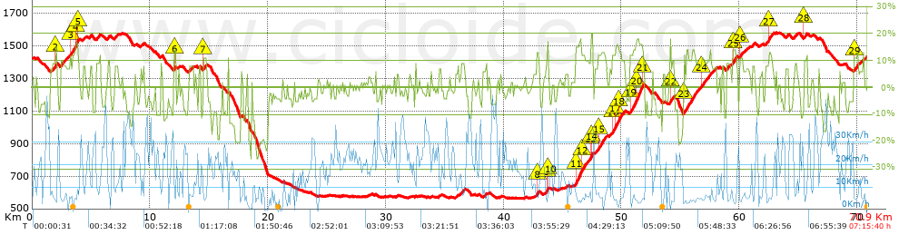
See analyis without corrections
DIFFICULTY OF THE ROUTE
IBP = 188 BYC
According to your statistics
 Your time in motion would be: ? h
Your average speed would be: ? Km/h
 

 Total Distance: 70.73 Km
 Analysed distance: 70.73 Km
 Linear distance: 0.1 Km

 Cumulated positive ramps: 2376.1 m  list of points info
 Cumulated negative ramps: 2363.12 m
 Maximum height: 1581.57 m
 Minimum height: 562.58 m
 Climbing Ratio: 7.56 %
 Descent ratio: 7.33 %
 Cumulated postive ramps per Km: 33.59 m
 Cumulated negative ramps per Km: 33.41 m

 Total time: 7:15:40 h
 Time in movement: 6:33:44 h
 According to your statistics
 Your time in motion would be: ? h  
 Stopped time: 0:41:56 h
 Maximum slope filter: ~30 %
 Minimum separation analysed: ~30 m
 Number of points: 4415   (cad. 16.02 m)
 Significant waypoints: 1857   (cad. 38.13 m / 42.06 %)

 Changes in direction per Km: 10.73
 Changes in direction > 5º por Km: 8.7
 Cumulated straight stretches: 9.298 Km
 Straight stretches per Km: 131.46 m
 Penalized slope changes: 18
 Penalized slope changes per Km: 0.254

 Average speed in total: 9.74 Km/h
 Average speed while moving: 10.78 Km/h
 According to your statistics
 Your average speed would be: ? Km/h  
 Maximum sustained speed: 52.33 Km/h


Comments

You can be the first one in commenting this route

 
My comments
:
Add comment  (Registered users)
 
Notify me answers to my comment  Do not notify answers to my comment


Share this route with a friend

Your friend will receive a message with a link to this page:
will see your email and your user name if you do it as registered user.


Write here your name (optional)

E-mail address of your friend(s). You can include various addresses separated by commas

Text or comment (optional) maximum 255 characters long, 255 Available characters

As a non registered users you need to fill-in the captcha text.
  Change image
Type the image characters.
 
 Share with a friend


Visited history

Delete history

Marked routes for review later or compare

My favorites


  Notify anomaly in this route Share in Facebook