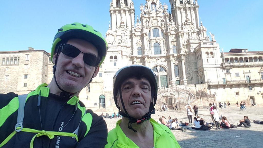
Feans (Elviña-Coruña, A) (A Coruña)

MTB
MTB
Ref..: 687197
Published: 25/04/2019
Performed: 28/03/2019
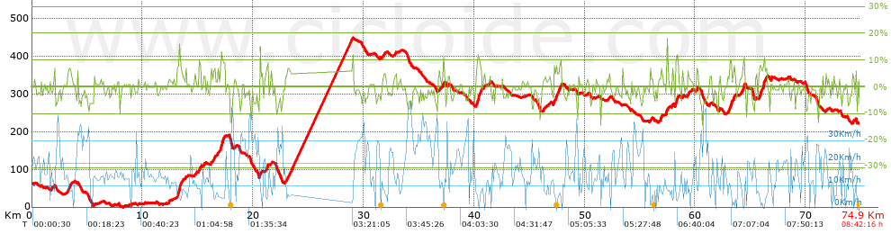
Distance in Km: 74.91
Climb in m: 1340
IBP: 93 BYC

troleiro
Author: troleiro
229 published routes

Add to my Group or Club

 Height in m      Climb in %      Speed in Km/h      Speed < 2 Km/h

Climbs > 5%

Climbs >5% Climbs >10% Climbs >15% Climbs >20% Climbs >25%
 Steep slope of 97 m.   Average slope  Distances  Download as waypoint
1
 Km 1.996  6%  97 m
 Steep slope of 279 m.  Average slope  Distances  Download as waypoint
2
 Km 3.261  6%  279 m
 Steep slope of 453 m.  Average slope  Distances  Download as waypoint
3
 Km 13.116  8%  175 m
4
 Km 13.291  13%  133 m
5
 Km 13.425  7%  145 m
 Steep slope of 154 m.  Average slope  Distances  Download as waypoint
6
 Km 15.137  9%  154 m
 Steep slope of 175 m.  Average slope  Distances  Download as waypoint
7
 Km 16.392  6%  175 m
 Steep slope of 408 m.  Average slope  Distances  Download as waypoint
8
 Km 17.042  7%  64 m
9
 Km 17.106  12%  135 m
10
 Km 17.242  8%  209 m
 Steep slope of 134 m.  Average slope  Distances  Download as waypoint
11
 Km 21.219  10%  134 m
 Steep slope of 470 m.  Average slope  Distances  Download as waypoint
12
 Km 23.103  6%  470 m
 Steep slope of 106 m.  Average slope  Distances  Download as waypoint
13
 Km 37.209  8%  106 m
 Steep slope of 498 m.  Average slope  Distances  Download as waypoint
14
 Km 40.237  8%  106 m
15
 Km 40.343  12%  140 m
16
 Km 40.483  7%  252 m
 Steep slope of 768 m.  Average slope  Distances  Download as waypoint
17
 Km 47.162  7%  768 m
 Steep slope of 108 m.  Average slope  Distances  Download as waypoint
18
 Km 56.858  8%  108 m
 Steep slope of 143 m.  Average slope  Distances  Download as waypoint
19
 Km 57.399  11%  143 m
 Steep slope of 281 m.  Average slope  Distances  Download as waypoint
20
 Km 58.203  10%  281 m
 Steep slope of 110 m.  Average slope  Distances  Download as waypoint
21
 Km 58.837  7%  110 m
 Steep slope of 156 m.  Average slope  Distances  Download as waypoint
22
 Km 60.091  6%  156 m
 Steep slope of 299 m.  Average slope  Distances  Download as waypoint
23
 Km 62.951  7%  299 m
 Steep slope of 169 m.  Average slope  Distances  Download as waypoint
24
 Km 63.448  8%  169 m
 Steep slope of 282 m.  Average slope  Distances  Download as waypoint
25
 Km 64.213  7%  145 m
26
 Km 64.358  12%  102 m
27
 Km 64.46  7%  35 m
 Steep slope of 698 m.  Average slope  Distances  Download as waypoint
28
 Km 65.806  8%  345 m
29
 Km 66.151  12%  134 m
30
 Km 66.285  7%  219 m


Description of the route


Presence of ramps


 Climbs  Distance  % of the total  Speed  Your speed would be  Time  Your time would be
   15 - 30%  0.108  0.14  7.78  ?  0:00:50  ?
   10 - 15%  1.28  1.71  5.61  ?  0:13:41  ?
   5 - 10%  11.412  15.23  5.08  ?  2:14:51  ?
   1 - 5%  15.656  20.9  10.14  ?  1:32:38  ?
   Total*  28.456 Km  37.99 %  7.06 Km/h  ? Km/h    4:02:00 h  ? h  
 Flat
   1 - -1%  16.978 Km  22.66 %  13.43 Km/h  ? Km/h    1:15:51 h  ? h  
 Descents
   -1 - -5%  21.464  28.65  18.63  ?  1:09:08  ?
   -5 - -10%  6.674  8.91  22.41  ?  0:17:52  ?
   -10 - -15%  1.303  1.74  12.06  ?  0:06:29  ?
   -15 - -30%  0.036  0.05  16.25  ?  0:00:08  ?
   Total*  29.477 Km  39.35 %  18.89 Km/h  ? Km/h    1:33:37 h  ? h  
* The total has not necessarily coincide with the sum of the partials after correction of errors

How long would it take you?

How long would it take you to cover this route?
There are routes without a valid time information, but with your average stats you can assess the possible duration

troleiro to cover this route you've need a time of:   6:51:28 h 
If you sign in and have a minimum of two tracks of this same modality, you can know your time for this route, calculated from your stats..


¿Cuanto consumirá tu E-BIKE?

Entra tu E-IBP (formato n,nn)

E-IBP :   X 93 = 


 Detected activity type =  ()
 Penalization due to track conditions: 62 %   ( > 50 % = MTB, < 50 % = RDB)
 Reliability of the track: B   (1340/58/0/-/-/58)
 Correction level applied to the track: 0
DIFFICULTY OF THE ROUTE
IBP = 93 BYC
According to your statistics
 Your time in motion would be: ? h
Your average speed would be: ? Km/h
 

 Total Distance: 74.91 Km
 Analysed distance: 74.91 Km
 Linear distance: 51.16 Km

 Cumulated positive ramps: 1340.1 m  list of points info
 Cumulated negative ramps: 1182.4 m
 Maximum height: 449 m
 Minimum height: 0.3 m
 Climbing Ratio: 4.71 %
 Descent ratio: 4.01 %
 Cumulated postive ramps per Km: 17.89 m
 Cumulated negative ramps per Km: 15.78 m

 Total time: 8:42:16 h
 Time in movement: 6:51:28 h
 According to your statistics
 Your time in motion would be: ? h  
 Stopped time: 1:50:48 h
 Maximum slope filter: ~30 %
 Minimum separation analysed: ~30 m
 Number of points: 5487   (cad. 13.65 m)
 Significant waypoints: 1930   (cad. 38.81 m / 35.17 %)

 Changes in direction per Km: 11.31
 Changes in direction > 5º por Km: 6.89
 Cumulated straight stretches: 17.089 Km
 Straight stretches per Km: 228.13 m
 Penalized slope changes: 10
 Penalized slope changes per Km: 0.133

 Average speed in total: 8.61 Km/h
 Average speed while moving: 10.92 Km/h
 According to your statistics
 Your average speed would be: ? Km/h  
 Maximum sustained speed: 49.63 Km/h


Comments

You can be the first one in commenting this route

 
My comments
:
Add comment  (Registered users)
 
Notify me answers to my comment  Do not notify answers to my comment


Share this route with a friend

Your friend will receive a message with a link to this page:
will see your email and your user name if you do it as registered user.


Write here your name (optional)

E-mail address of your friend(s). You can include various addresses separated by commas

Text or comment (optional) maximum 255 characters long, 255 Available characters

As a non registered users you need to fill-in the captcha text.
  Change image
Type the image characters.
 
 Share with a friend


Visited history

Delete history

Marked routes for review later or compare

My favorites


  Notify anomaly in this route Share in Facebook