Pasquetta Detox

MTB
MTB
Ref..: 686063
Published: 24/04/2019
Performed: 22/04/2019
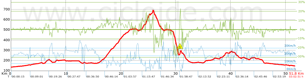
Distance in Km: 51.82
Climb in m: 922
IBP: 68 BYC

Beppe Cavalli
569 published routes

Add to my Group or Club

 Height in m      Climb in %      Speed in Km/h      Speed < 2 Km/h

Climbs > 5%

Climbs >5% Climbs >10% Climbs >15% Climbs >20% Climbs >25%
 Steep slope of 292 m.   Average slope  Distances  Download as waypoint
1
 Km 6.225  7%  292 m
 Steep slope of 219 m.  Average slope  Distances  Download as waypoint
2
 Km 8.071  7%  219 m
 Steep slope of 237 m.  Average slope  Distances  Download as waypoint
3
 Km 16.36  6%  237 m
 Steep slope of 324 m.  Average slope  Distances  Download as waypoint
4
 Km 17.097  7%  324 m
 Steep slope of 710 m.  Average slope  Distances  Download as waypoint
5
 Km 17.52  7%  710 m
 Steep slope of 666 m.  Average slope  Distances  Download as waypoint
6
 Km 18.615  7%  666 m
 Steep slope of 508 m.  Average slope  Distances  Download as waypoint
7
 Km 19.426  7%  132 m
8
 Km 19.559  9%  139 m
9
 Km 19.698  9%  237 m
 Steep slope of 494 m.  Average slope  Distances  Download as waypoint
10
 Km 20.038  7%  494 m
 Steep slope of 105 m.  Average slope  Distances  Download as waypoint
11
 Km 20.776  6%  105 m
 Steep slope of 278 m.  Average slope  Distances  Download as waypoint
12
 Km 21.275  8%  278 m
 Steep slope of 475 m.  Average slope  Distances  Download as waypoint
13
 Km 23.817  11%  136 m
14
 Km 23.953  10%  339 m
 Steep slope of 711 m.  Average slope  Distances  Download as waypoint
15
 Km 24.497  19%  191 m
16
 Km 24.688  12%  196 m
17
 Km 24.883  9%  163 m
18
 Km 25.046  15%  161 m
 Steep slope of 106 m.  Average slope  Distances  Download as waypoint
19
 Km 25.376  9%  106 m
 Steep slope of 257 m.  Average slope  Distances  Download as waypoint
20
 Km 25.653  8%  101 m
21
 Km 25.754  18%  124 m
22
 Km 25.878  7%  32 m
 Steep slope of 112 m.  Average slope  Distances  Download as waypoint
23
 Km 28.006  7%  112 m
 Steep slope of 188 m.  Average slope  Distances  Download as waypoint
24
 Km 30.741  16%  33 m
25
 Km 30.774  23%  94 m
26
 Km 30.869  18%  61 m
 Steep slope of 166 m.  Average slope  Distances  Download as waypoint
27
 Km 35.287  5%  166 m
 Steep slope of 110 m.  Average slope  Distances  Download as waypoint
28
 Km 36.928  6%  110 m
 Steep slope of 138 m.  Average slope  Distances  Download as waypoint
29
 Km 38.07  8%  138 m
 Steep slope of 137 m.  Average slope  Distances  Download as waypoint
30
 Km 38.505  6%  137 m
 Steep slope of 307 m.  Average slope  Distances  Download as waypoint
31
 Km 38.75  7%  204 m
32
 Km 38.954  12%  103 m
 Steep slope of 103 m.  Average slope  Distances  Download as waypoint
33
 Km 39.752  11%  103 m


Description of the route


Presence of ramps


 Climbs  Distance  % of the total  Speed  Your speed would be  Time  Your time would be
   15 - 30%  0.699  1.35  4.71  ?  0:08:54  ?
   10 - 15%  0.966  1.86  7.68  ?  0:07:33  ?
   5 - 10%  6.039  11.65  11.41  ?  0:31:46  ?
   1 - 5%  10.517  20.3  17.22  ?  0:36:38  ?
   Total*  18.22 Km  35.16 %  12.88 Km/h  ? Km/h    1:24:51 h  ? h  
 Flat
   1 - -1%  18.704 Km  36.1 %  23.97 Km/h  ? Km/h    0:46:49 h  ? h  
 Descents
   -1 - -5%  9.544  18.42  25.49  ?  0:22:28  ?
   -5 - -10%  2.645  5.11  22.78  ?  0:06:58  ?
   -10 - -15%  1.006  1.94  17.67  ?  0:03:25  ?
   -15 - -30%  1.698  3.28  8.78  ?  0:11:36  ?
   Total*  14.894 Km  28.74 %  20.1 Km/h  ? Km/h    0:44:27 h  ? h  
* The total has not necessarily coincide with the sum of the partials after correction of errors

How long would it take you?

How long would it take you to cover this route?
There are routes without a valid time information, but with your average stats you can assess the possible duration

Beppe Cavalli to cover this route you've need a time of:   2:56:07 h 
If you sign in and have a minimum of two tracks of this same modality, you can know your time for this route, calculated from your stats..


¿Cuanto consumirá tu E-BIKE?

Entra tu E-IBP (formato n,nn)

E-IBP :   X 68 = 


 Detected activity type =  ()
 Penalization due to track conditions: 51 %   ( > 50 % = MTB, < 50 % = RDB)
 Reliability of the track: B   (924/71/0/-/-/71)
 Correction level applied to the track: 0
DIFFICULTY OF THE ROUTE
IBP = 68 BYC
According to your statistics
 Your time in motion would be: ? h
Your average speed would be: ? Km/h
 

 Total Distance: 51.82 Km
 Analysed distance: 51.82 Km
 Linear distance: 0.02 Km

 Cumulated positive ramps: 922.44 m  list of points info
 Cumulated negative ramps: 914.04 m
 Maximum height: 692.8 m
 Minimum height: 134.6 m
 Climbing Ratio: 5.06 %
 Descent ratio: 6.14 %
 Cumulated postive ramps per Km: 17.8 m
 Cumulated negative ramps per Km: 17.64 m

 Total time: 3:02:51 h
 Time in movement: 2:56:07 h
 According to your statistics
 Your time in motion would be: ? h  
 Stopped time: 0:06:44 h
 Maximum slope filter: ~30 %
 Minimum separation analysed: ~30 m
 Number of points: 3959   (cad. 13.09 m)
 Significant waypoints: 1472   (cad. 35.2 m / 37.18 %)

 Changes in direction per Km: 10.54
 Changes in direction > 5º por Km: 5.44
 Cumulated straight stretches: 17.134 Km
 Straight stretches per Km: 330.64 m
 Penalized slope changes: 9
 Penalized slope changes per Km: 0.174

 Average speed in total: 17 Km/h
 Average speed while moving: 17.65 Km/h
 According to your statistics
 Your average speed would be: ? Km/h  
 Maximum sustained speed: 41.65 Km/h


Comments

You can be the first one in commenting this route

 
My comments
:
Add comment  (Registered users)
 
Notify me answers to my comment  Do not notify answers to my comment


Share this route with a friend

Your friend will receive a message with a link to this page:
will see your email and your user name if you do it as registered user.


Write here your name (optional)

E-mail address of your friend(s). You can include various addresses separated by commas

Text or comment (optional) maximum 255 characters long, 255 Available characters

As a non registered users you need to fill-in the captcha text.
  Change image
Type the image characters.
 
 Share with a friend


Visited history

Delete history

Marked routes for review later or compare

My favorites


  Notify anomaly in this route Share in Facebook