Canedo (Ponteareas) (Pontevedra)

MTB
MTB
Ref..: 683566
Published: 22/04/2019
Performed: 19/04/2019
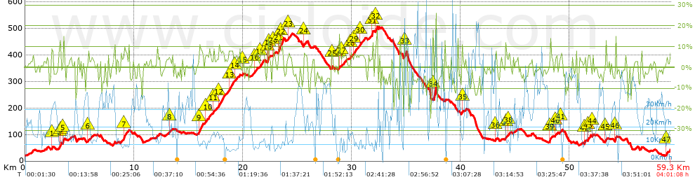
Distance in Km: 59.31
Climb in m: 1389
IBP: 97 BYC

Near ...
Abelleira (Angoares), Angoares (San Pedro), Arcos (Ponteareas), Areas (Ponteareas), Bugarin (Santa Cristina), Canedo (Ponteareas)
Carlos_Sotelino
264 published routes

Add to my Group or Club

 Height in m      Climb in %      Speed in Km/h      Speed < 2 Km/h

Climbs > 5%

Climbs >5% Climbs >10% Climbs >15% Climbs >20% Climbs >25%
 Steep slope of 170 m.   Average slope  Distances  Download as waypoint
1
 Km 2.424  8%  170 m
 Steep slope of 175 m.  Average slope  Distances  Download as waypoint
2
 Km 3.143  9%  74 m
3
 Km 3.218  15%  101 m
 Steep slope of 152 m.  Average slope  Distances  Download as waypoint
4
 Km 3.456  7%  37 m
5
 Km 3.493  13%  115 m
 Steep slope of 93 m.  Average slope  Distances  Download as waypoint
6
 Km 5.807  6%  93 m
 Steep slope of 307 m.  Average slope  Distances  Download as waypoint
7
 Km 9.051  9%  307 m
 Steep slope of 111 m.  Average slope  Distances  Download as waypoint
8
 Km 13.226  5%  111 m
 Steep slope of 389 m.  Average slope  Distances  Download as waypoint
9
 Km 15.982  9%  389 m
 Steep slope of 498 m.  Average slope  Distances  Download as waypoint
10
 Km 16.516  6%  498 m
 Steep slope of 110 m.  Average slope  Distances  Download as waypoint
11
 Km 17.308  7%  110 m
 Steep slope of 542 m.  Average slope  Distances  Download as waypoint
12
 Km 17.799  8%  542 m
 Steep slope of 381 m.  Average slope  Distances  Download as waypoint
13
 Km 18.749  8%  381 m
 Steep slope of 189 m.  Average slope  Distances  Download as waypoint
14
 Km 19.275  5%  189 m
 Steep slope of 111 m.  Average slope  Distances  Download as waypoint
15
 Km 19.991  6%  111 m
 Steep slope of 298 m.  Average slope  Distances  Download as waypoint
16
 Km 21.032  6%  298 m
 Steep slope of 350 m.  Average slope  Distances  Download as waypoint
17
 Km 21.585  7%  350 m
 Steep slope of 157 m.  Average slope  Distances  Download as waypoint
18
 Km 22.258  15%  119 m
19
 Km 22.377  5%  38 m
 Steep slope of 176 m.  Average slope  Distances  Download as waypoint
20
 Km 22.809  6%  176 m
 Steep slope of 470 m.  Average slope  Distances  Download as waypoint
21
 Km 23.273  12%  183 m
22
 Km 23.457  11%  287 m
 Steep slope of 353 m.  Average slope  Distances  Download as waypoint
23
 Km 24.123  6%  353 m
 Steep slope of 266 m.  Average slope  Distances  Download as waypoint
24
 Km 25.602  6%  266 m
 Steep slope of 94 m.  Average slope  Distances  Download as waypoint
25
 Km 28.121  8%  94 m
 Steep slope of 109 m.  Average slope  Distances  Download as waypoint
26
 Km 28.827  8%  109 m
 Steep slope of 369 m.  Average slope  Distances  Download as waypoint
27
 Km 29.083  5%  369 m
 Steep slope of 146 m.  Average slope  Distances  Download as waypoint
28
 Km 29.899  6%  146 m
 Steep slope of 426 m.  Average slope  Distances  Download as waypoint
29
 Km 30.189  6%  426 m
 Steep slope of 331 m.  Average slope  Distances  Download as waypoint
30
 Km 30.722  6%  331 m
 Steep slope of 118 m.  Average slope  Distances  Download as waypoint
31
 Km 31.852  14%  118 m
 Steep slope of 196 m.  Average slope  Distances  Download as waypoint
32
 Km 32.136  7%  196 m
 Steep slope of 226 m.  Average slope  Distances  Download as waypoint
33
 Km 34.842  12%  226 m
 Steep slope of 122 m.  Average slope  Distances  Download as waypoint
34
 Km 37.441  5%  122 m
 Steep slope of 94 m.  Average slope  Distances  Download as waypoint
35
 Km 40.132  9%  94 m
 Steep slope of 99 m.  Average slope  Distances  Download as waypoint
36
 Km 43.208  7%  99 m
 Steep slope of 121 m.  Average slope  Distances  Download as waypoint
37
 Km 44.146  7%  121 m
 Steep slope of 110 m.  Average slope  Distances  Download as waypoint
38
 Km 44.413  7%  110 m
 Steep slope of 109 m.  Average slope  Distances  Download as waypoint
39
 Km 48.158  12%  109 m
 Steep slope of 179 m.  Average slope  Distances  Download as waypoint
40
 Km 48.675  6%  179 m
 Steep slope of 160 m.  Average slope  Distances  Download as waypoint
41
 Km 49.138  6%  160 m
 Steep slope of 140 m.  Average slope  Distances  Download as waypoint
42
 Km 51.354  8%  140 m
 Steep slope of 254 m.  Average slope  Distances  Download as waypoint
43
 Km 51.668  8%  254 m
 Steep slope of 136 m.  Average slope  Distances  Download as waypoint
44
 Km 52.067  6%  136 m
 Steep slope of 148 m.  Average slope  Distances  Download as waypoint
45
 Km 53.301  9%  148 m
 Steep slope of 143 m.  Average slope  Distances  Download as waypoint
46
 Km 54.157  13%  143 m
 Steep slope of 111 m.  Average slope  Distances  Download as waypoint
47
 Km 58.851  6%  111 m


Description of the route


Presence of ramps


 Climbs  Distance  % of the total  Speed  Your speed would be  Time  Your time would be
   15 - 30%  0.467  0.79  20.25  ?  0:01:23  ?
   10 - 15%  1.812  3.06  16.51  ?  0:06:35  ?
   5 - 10%  9.308  15.69  13.26  ?  0:42:07  ?
   1 - 5%  14.907  25.14  16.49  ?  0:54:15  ?
   Total*  26.493 Km  44.67 %  15.24 Km/h  ? Km/h    1:44:20 h  ? h  
 Flat
   1 - -1%  8.496 Km  14.33 %  20.75 Km/h  ? Km/h    0:24:34 h  ? h  
 Descents
   -1 - -5%  12.932  21.8  26.08  ?  0:29:45  ?
   -5 - -10%  8.611  14.52  30.36  ?  0:17:01  ?
   -10 - -15%  1.835  3.09  36.31  ?  0:03:02  ?
   -15 - -30%  0.938  1.58  30.15  ?  0:01:52  ?
   Total*  24.316 Km  41 %  28.24 Km/h  ? Km/h    0:51:40 h  ? h  
* The total has not necessarily coincide with the sum of the partials after correction of errors

How long would it take you?

How long would it take you to cover this route?
There are routes without a valid time information, but with your average stats you can assess the possible duration

Carlos_Sotelino to cover this route you've need a time of:   3:00:34 h 
If you sign in and have a minimum of two tracks of this same modality, you can know your time for this route, calculated from your stats..


¿Cuanto consumirá tu E-BIKE?

Entra tu E-IBP (formato n,nn)

E-IBP :   X 97 = 


 Detected activity type =  ()
 Penalization due to track conditions: 73 %   ( > 50 % = MTB, < 50 % = RDB)
 Reliability of the track: C   (1389/56/0/-/-/56)
 Correction level applied to the track: 0
DIFFICULTY OF THE ROUTE
IBP = 97 BYC
According to your statistics
 Your time in motion would be: ? h
Your average speed would be: ? Km/h
 

 Total Distance: 59.31 Km
 Analysed distance: 59.31 Km
 Linear distance: 0.51 Km

 Cumulated positive ramps: 1389 m  list of points info
 Cumulated negative ramps: 1366 m
 Maximum height: 505.7 m
 Minimum height: 21 m
 Climbing Ratio: 5.24 %
 Descent ratio: 5.62 %
 Cumulated postive ramps per Km: 23.42 m
 Cumulated negative ramps per Km: 23.03 m

 Total time: 4:01:08 h
 Time in movement: 3:00:34 h
 According to your statistics
 Your time in motion would be: ? h  
 Stopped time: 1:00:34 h
 Maximum slope filter: ~30 %
 Minimum separation analysed: ~30 m
 Number of points: 4234   (cad. 14.01 m)
 Significant waypoints: 1575   (cad. 37.65 m / 37.2 %)

 Changes in direction per Km: 11.28
 Changes in direction > 5º por Km: 8.21
 Cumulated straight stretches: 8.685 Km
 Straight stretches per Km: 146.43 m
 Penalized slope changes: 7
 Penalized slope changes per Km: 0.118

 Average speed in total: 14.76 Km/h
 Average speed while moving: 19.71 Km/h
 According to your statistics
 Your average speed would be: ? Km/h  
 Maximum sustained speed: 74.44 Km/h


Comments

You can be the first one in commenting this route

 
My comments
:
Add comment  (Registered users)
 
Notify me answers to my comment  Do not notify answers to my comment


Share this route with a friend

Your friend will receive a message with a link to this page:
will see your email and your user name if you do it as registered user.


Write here your name (optional)

E-mail address of your friend(s). You can include various addresses separated by commas

Text or comment (optional) maximum 255 characters long, 255 Available characters

As a non registered users you need to fill-in the captcha text.
  Change image
Type the image characters.
 
 Share with a friend


Visited history

Delete history

Marked routes for review later or compare

My favorites


  Notify anomaly in this route Share in Facebook