Escarchon Trail 2018

Running
Running
Ref..: 614520
Published: 14/02/2019
Performed: 19/11/2017
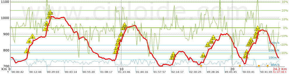
Distance in Km: 24.17
Climb in m: 1166
IBP: 241 RNG

Jorrupi_Chulilla
167 published routes

Add to my Group or Club

 Height in m      Climb in %      Speed in Km/h      Speed < 2 Km/h

Climbs > 5%

Climbs >5% Climbs >10% Climbs >15% Climbs >20% Climbs >25%
 Steep slope of 137 m.   Average slope  Distances  Download as waypoint
1
 Km 0.535  5%  137 m
 Steep slope of 296 m.  Average slope  Distances  Download as waypoint
2
 Km 1.44  15%  35 m
3
 Km 1.476  35%  149 m
4
 Km 1.625  25%  79 m
5
 Km 1.703  19%  33 m
 Steep slope of 186 m.  Average slope  Distances  Download as waypoint
6
 Km 1.848  7%  75 m
7
 Km 1.923  31%  74 m
8
 Km 1.997  16%  37 m
 Steep slope of 583 m.  Average slope  Distances  Download as waypoint
9
 Km 3.049  7%  45 m
10
 Km 3.094  9%  90 m
11
 Km 3.184  43%  112 m
12
 Km 3.296  43%  29 m
13
 Km 3.325  5%  119 m
14
 Km 3.444  30%  109 m
15
 Km 3.553  37%  30 m
16
 Km 3.583  21%  49 m
 Steep slope of 108 m.  Average slope  Distances  Download as waypoint
17
 Km 6.168  6%  108 m
 Steep slope of 439 m.  Average slope  Distances  Download as waypoint
18
 Km 9.41  25%  112 m
19
 Km 9.522  27%  79 m
20
 Km 9.601  17%  102 m
21
 Km 9.703  34%  107 m
22
 Km 9.81  46%  39 m
 Steep slope of 489 m.  Average slope  Distances  Download as waypoint
23
 Km 9.978  11%  38 m
24
 Km 10.016  25%  145 m
25
 Km 10.161  17%  90 m
26
 Km 10.25  18%  70 m
27
 Km 10.32  11%  146 m
 Steep slope of 107 m.  Average slope  Distances  Download as waypoint
28
 Km 13.66  10%  107 m
 Steep slope of 261 m.  Average slope  Distances  Download as waypoint
29
 Km 14.563  12%  73 m
30
 Km 14.636  20%  44 m
31
 Km 14.68  29%  144 m
 Steep slope of 123 m.  Average slope  Distances  Download as waypoint
32
 Km 14.919  10%  123 m
 Steep slope of 115 m.  Average slope  Distances  Download as waypoint
33
 Km 17.022  10%  115 m
 Steep slope of 525 m.  Average slope  Distances  Download as waypoint
34
 Km 17.365  8%  41 m
35
 Km 17.406  18%  313 m
36
 Km 17.719  16%  120 m
37
 Km 17.839  9%  51 m
 Steep slope of 528 m.  Average slope  Distances  Download as waypoint
38
 Km 18.053  11%  215 m
39
 Km 18.268  12%  102 m
40
 Km 18.37  10%  211 m
 Steep slope of 253 m.  Average slope  Distances  Download as waypoint
41
 Km 18.693  16%  253 m
 Steep slope of 774 m.  Average slope  Distances  Download as waypoint
42
 Km 21.131  11%  38 m
43
 Km 21.169  28%  142 m
44
 Km 21.311  24%  125 m
45
 Km 21.436  11%  139 m
46
 Km 21.575  14%  113 m
47
 Km 21.688  13%  163 m
48
 Km 21.851  6%  54 m
 Steep slope of 300 m.  Average slope  Distances  Download as waypoint
49
 Km 22.058  15%  90 m
50
 Km 22.148  23%  34 m
51
 Km 22.183  41%  108 m
52
 Km 22.291  37%  30 m
53
 Km 22.321  6%  38 m
 Steep slope of 124 m.  Average slope  Distances  Download as waypoint
54
 Km 22.548  5%  124 m


Description of the route


Presence of ramps


 Climbs  Distance  % of the total  Speed  Your speed would be  Time  Your time would be
   15 - 30%  1.919  7.94  3.83  ?  0:30:05  ?
   10 - 15%  1.115  4.61  4.67  ?  0:14:20  ?
   5 - 10%  2.299  9.51  6.08  ?  0:22:42  ?
   1 - 5%  3.377  13.97  7.27  ?  0:27:52  ?
   Total*  9.657 Km  39.95 %  4.93 Km/h  ? Km/h    1:57:29 h  ? h  
 Flat
   1 - -1%  2.541 Km  10.51 %  6.42 Km/h  ? Km/h    0:23:45 h  ? h  
 Descents
   -1 - -5%  4.513  18.67  7.78  ?  0:34:49  ?
   -5 - -10%  3.013  12.47  7.7  ?  0:23:28  ?
   -10 - -15%  1.802  7.45  7.58  ?  0:14:16  ?
   -15 - -30%  2.298  9.51  5.93  ?  0:23:15  ?
   Total*  11.973 Km  49.53 %  7.17 Km/h  ? Km/h    1:40:14 h  ? h  
* The total has not necessarily coincide with the sum of the partials after correction of errors

How long would it take you?

How long would it take you to cover this route?
There are routes without a valid time information, but with your average stats you can assess the possible duration

Jorrupi_Chulilla to cover this route you've need a time of:   4:01:28 h 
If you sign in and have a minimum of two tracks of this same modality, you can know your time for this route, calculated from your stats..


 Detected activity type =  ()
 Penalization due to track conditions: 0 %   ( > 50 % = MTB, < 50 % = RDB)
 Reliability of the track: C   (1166/56/0/-/-/56)
 Correction level applied to the track: 0
DIFFICULTY OF THE ROUTE
IBP = 241 RNG
According to your statistics
 Your time in motion would be: ? h
Your average speed would be: ? Km/h
 

 Total Distance: 24.17 Km
 Analysed distance: 24.17 Km
 Linear distance: 0 Km

 Cumulated positive ramps: 1165.75 m  list of points info
 Cumulated negative ramps: 1166.38 m
 Maximum height: 1010.16 m
 Minimum height: 701.32 m
 Climbing Ratio: 12.07 %
 Descent ratio: 9.74 %
 Cumulated postive ramps per Km: 48.23 m
 Cumulated negative ramps per Km: 48.26 m

 Total time: 51:07:08 h
 Time in movement: 4:01:28 h
 According to your statistics
 Your time in motion would be: ? h  
 Stopped time: 47:05:40 h
 Maximum slope filter: ~55 %
 Minimum separation analysed: ~30 m
 Number of points: 1282   (cad. 18.85 m)
 Significant waypoints: 605   (cad. 39.95 m / 47.19 %)

 Changes in direction per Km: 12.62
 Changes in direction > 5º por Km: 9.97
 Cumulated straight stretches: 2.702 Km
 Straight stretches per Km: 111.79 m
 Penalized slope changes: 14
 Penalized slope changes per Km: 0.579

 Average speed in total: 0.47 Km/h
 Average speed while moving: 6.01 Km/h
 According to your statistics
 Your average speed would be: ? Km/h  
 Maximum sustained speed: 13.22 Km/h


Comments

You can be the first one in commenting this route

 
My comments
:
Add comment  (Registered users)
 
Notify me answers to my comment  Do not notify answers to my comment


Share this route with a friend

Your friend will receive a message with a link to this page:
will see your email and your user name if you do it as registered user.


Write here your name (optional)

E-mail address of your friend(s). You can include various addresses separated by commas

Text or comment (optional) maximum 255 characters long, 255 Available characters

As a non registered users you need to fill-in the captcha text.
  Change image
Type the image characters.
 
 Share with a friend


Visited history

Delete history

Marked routes for review later or compare

My favorites


  Notify anomaly in this route Share in Facebook