Finde de montaña al completo

MTB
MTB
Ref..: 612356
Published: 12/02/2019
Performed: 10/02/2019
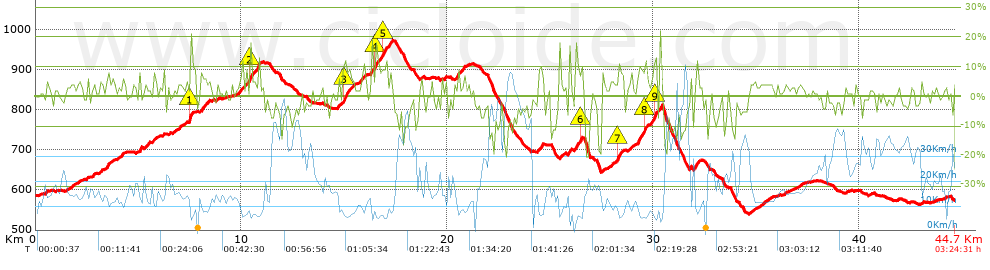
Distance in Km: 44.72
Climb in m: 1063
IBP: 77 BYC

Fermin_Tardon
58 published routes

Add to my Group or Club

 Height in m      Climb in %      Speed in Km/h      Speed < 2 Km/h

Climbs > 5%

Climbs >5% Climbs >10% Climbs >15% Climbs >20% Climbs >25%
 Steep slope of 207 m.   Average slope  Distances  Download as waypoint
1
 Km 3.381  6%  207 m
 Steep slope of 111 m.  Average slope  Distances  Download as waypoint
2
 Km 4.155  7%  111 m
 Steep slope of 171 m.  Average slope  Distances  Download as waypoint
3
 Km 5.282  5%  171 m
 Steep slope of 149 m.  Average slope  Distances  Download as waypoint
4
 Km 7.469  14%  149 m
 Steep slope of 331 m.  Average slope  Distances  Download as waypoint
5
 Km 8.001  7%  331 m
 Steep slope of 158 m.  Average slope  Distances  Download as waypoint
6
 Km 9.863  6%  158 m
 Steep slope of 182 m.  Average slope  Distances  Download as waypoint
7
 Km 10.399  14%  104 m
8
 Km 10.503  6%  78 m
 Steep slope of 150 m.  Average slope  Distances  Download as waypoint
9
 Km 10.682  8%  109 m
10
 Km 10.79  17%  41 m
 Steep slope of 460 m.  Average slope  Distances  Download as waypoint
11
 Km 14.713  5%  204 m
12
 Km 14.917  11%  178 m
13
 Km 15.095  10%  78 m
 Steep slope of 140 m.  Average slope  Distances  Download as waypoint
14
 Km 15.336  5%  140 m
 Steep slope of 129 m.  Average slope  Distances  Download as waypoint
15
 Km 15.841  7%  129 m
 Steep slope of 850 m.  Average slope  Distances  Download as waypoint
16
 Km 16.496  11%  105 m
17
 Km 16.601  7%  278 m
18
 Km 16.879  11%  133 m
19
 Km 17.012  6%  149 m
20
 Km 17.161  8%  185 m
 Steep slope of 148 m.  Average slope  Distances  Download as waypoint
21
 Km 19.858  6%  148 m
 Steep slope of 149 m.  Average slope  Distances  Download as waypoint
22
 Km 20.45  9%  114 m
23
 Km 20.564  10%  35 m
 Steep slope of 148 m.  Average slope  Distances  Download as waypoint
24
 Km 20.7  6%  148 m
 Steep slope of 209 m.  Average slope  Distances  Download as waypoint
25
 Km 24.4  8%  209 m
 Steep slope of 101 m.  Average slope  Distances  Download as waypoint
26
 Km 25.443  11%  101 m
 Steep slope of 329 m.  Average slope  Distances  Download as waypoint
27
 Km 26.231  9%  222 m
28
 Km 26.453  11%  107 m
 Steep slope of 97 m.  Average slope  Distances  Download as waypoint
29
 Km 27.491  8%  97 m
 Steep slope of 256 m.  Average slope  Distances  Download as waypoint
30
 Km 28.266  12%  100 m
31
 Km 28.366  7%  156 m
 Steep slope of 397 m.  Average slope  Distances  Download as waypoint
32
 Km 29.327  8%  279 m
33
 Km 29.606  11%  118 m
 Steep slope of 315 m.  Average slope  Distances  Download as waypoint
34
 Km 29.89  7%  122 m
35
 Km 30.012  13%  193 m
 Steep slope of 100 m.  Average slope  Distances  Download as waypoint
36
 Km 30.314  18%  100 m
 Steep slope of 141 m.  Average slope  Distances  Download as waypoint
37
 Km 32  8%  141 m
 Steep slope of 122 m.  Average slope  Distances  Download as waypoint
38
 Km 42.995  7%  122 m


Description of the route


Presence of ramps


 Climbs  Distance  % of the total  Speed  Your speed would be  Time  Your time would be
   15 - 30%  0.52  1.16  6.07  ?  0:05:08  ?
   10 - 15%  1.743  3.9  7.37  ?  0:14:11  ?
   5 - 10%  5.242  11.72  10  ?  0:31:28  ?
   1 - 5%  13.53  30.25  13.74  ?  0:59:05  ?
   Total*  21.034 Km  47.03 %  11.49 Km/h  ? Km/h    1:49:52 h  ? h  
 Flat
   1 - -1%  6.279 Km  14.04 %  17.9 Km/h  ? Km/h    0:21:03 h  ? h  
 Descents
   -1 - -5%  8.719  19.5  22.5  ?  0:23:15  ?
   -5 - -10%  5.065  11.32  28.9  ?  0:10:31  ?
   -10 - -15%  2.671  5.97  34.84  ?  0:04:36  ?
   -15 - -30%  0.955  2.13  23.38  ?  0:02:27  ?
   Total*  17.409 Km  38.93 %  25.59 Km/h  ? Km/h    0:40:49 h  ? h  
* The total has not necessarily coincide with the sum of the partials after correction of errors

How long would it take you?

How long would it take you to cover this route?
There are routes without a valid time information, but with your average stats you can assess the possible duration

Fermin_Tardon to cover this route you've need a time of:   2:51:44 h 
If you sign in and have a minimum of two tracks of this same modality, you can know your time for this route, calculated from your stats..


¿Cuanto consumirá tu E-BIKE?

Entra tu E-IBP (formato n,nn)

E-IBP :   X 77 = 


 Detected activity type =  ()
 Penalization due to track conditions: 69 %   ( > 50 % = MTB, < 50 % = RDB)
 Reliability of the track: C   (1063/54/0/-/-/54)
 Correction level applied to the track: 0
DIFFICULTY OF THE ROUTE
IBP = 77 BYC
According to your statistics
 Your time in motion would be: ? h
Your average speed would be: ? Km/h
 

 Total Distance: 44.72 Km
 Analysed distance: 44.72 Km
 Linear distance: 0.06 Km

 Cumulated positive ramps: 1063.4 m  list of points info
 Cumulated negative ramps: 1083.8 m
 Maximum height: 972.4 m
 Minimum height: 540 m
 Climbing Ratio: 5.06 %
 Descent ratio: 6.23 %
 Cumulated postive ramps per Km: 23.78 m
 Cumulated negative ramps per Km: 24.24 m

 Total time: 3:24:31 h
 Time in movement: 2:51:44 h
 According to your statistics
 Your time in motion would be: ? h  
 Stopped time: 0:32:47 h
 Maximum slope filter: ~30 %
 Minimum separation analysed: ~30 m
 Number of points: 2287   (cad. 19.56 m)
 Significant waypoints: 1100   (cad. 40.66 m / 48.1 %)

 Changes in direction per Km: 9.82
 Changes in direction > 5º por Km: 6.95
 Cumulated straight stretches: 11.184 Km
 Straight stretches per Km: 250.09 m
 Penalized slope changes: 13
 Penalized slope changes per Km: 0.291

 Average speed in total: 13.12 Km/h
 Average speed while moving: 15.62 Km/h
 According to your statistics
 Your average speed would be: ? Km/h  
 Maximum sustained speed: 67.6 Km/h


Comments

You can be the first one in commenting this route

 
My comments
:
Add comment  (Registered users)
 
Notify me answers to my comment  Do not notify answers to my comment


Share this route with a friend

Your friend will receive a message with a link to this page:
will see your email and your user name if you do it as registered user.


Write here your name (optional)

E-mail address of your friend(s). You can include various addresses separated by commas

Text or comment (optional) maximum 255 characters long, 255 Available characters

As a non registered users you need to fill-in the captcha text.
  Change image
Type the image characters.
 
 Share with a friend


Visited history

Delete history

Marked routes for review later or compare

My favorites


  Notify anomaly in this route Share in Facebook