Ruta De Las Tierras Altas - Moncalvillo

MTB
MTB
Ref..: 550899
Published: 08/12/2018
Performed: 07/12/2018
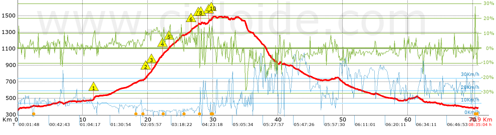
Distance in Km: 70.88
Climb in m: 1573
IBP: 109 BYC


 Height in m      Climb in %      Speed in Km/h      Speed < 2 Km/h

Climbs > 5%

Climbs >5% Climbs >10% Climbs >15% Climbs >20% Climbs >25%
 Steep slope of 208 m.   Average slope  Distances  Download as waypoint
1
 Km 0.074  8%  208 m
 Steep slope of 430 m.  Average slope  Distances  Download as waypoint
2
 Km 11.534  7%  123 m
3
 Km 11.657  12%  233 m
4
 Km 11.89  6%  74 m
 Steep slope of 128 m.  Average slope  Distances  Download as waypoint
5
 Km 14.756  5%  128 m
 Steep slope of 162 m.  Average slope  Distances  Download as waypoint
6
 Km 17.589  7%  162 m
 Steep slope of 154 m.  Average slope  Distances  Download as waypoint
7
 Km 18.261  6%  154 m
 Steep slope of 3310 m.  Average slope  Distances  Download as waypoint
8
 Km 19.234  6%  393 m
9
 Km 19.627  10%  235 m
10
 Km 19.861  9%  658 m
11
 Km 20.52  12%  1382 m
12
 Km 21.901  8%  119 m
13
 Km 22.02  9%  277 m
14
 Km 22.297  12%  215 m
15
 Km 22.513  12%  31 m
 Steep slope of 1261 m.  Average slope  Distances  Download as waypoint
16
 Km 22.684  8%  553 m
17
 Km 23.237  10%  143 m
18
 Km 23.38  8%  565 m
 Steep slope of 835 m.  Average slope  Distances  Download as waypoint
19
 Km 24.132  8%  794 m
20
 Km 24.925  11%  41 m
 Steep slope of 211 m.  Average slope  Distances  Download as waypoint
21
 Km 25.06  11%  68 m
22
 Km 25.128  9%  143 m
 Steep slope of 178 m.  Average slope  Distances  Download as waypoint
23
 Km 25.879  5%  178 m
 Steep slope of 626 m.  Average slope  Distances  Download as waypoint
24
 Km 26.182  7%  500 m
25
 Km 26.682  13%  126 m
 Steep slope of 231 m.  Average slope  Distances  Download as waypoint
26
 Km 26.837  6%  101 m
27
 Km 26.938  6%  130 m
 Steep slope of 225 m.  Average slope  Distances  Download as waypoint
28
 Km 27.202  7%  225 m
 Steep slope of 259 m.  Average slope  Distances  Download as waypoint
29
 Km 27.645  8%  68 m
30
 Km 27.713  13%  191 m
 Steep slope of 162 m.  Average slope  Distances  Download as waypoint
31
 Km 28.151  13%  162 m
 Steep slope of 433 m.  Average slope  Distances  Download as waypoint
32
 Km 29.121  8%  253 m
33
 Km 29.374  15%  137 m
34
 Km 29.511  8%  43 m
 Steep slope of 368 m.  Average slope  Distances  Download as waypoint
35
 Km 29.699  8%  74 m
36
 Km 29.773  11%  235 m
37
 Km 30.008  10%  59 m
 Steep slope of 136 m.  Average slope  Distances  Download as waypoint
38
 Km 30.721  7%  136 m
 Steep slope of 192 m.  Average slope  Distances  Download as waypoint
39
 Km 32.661  8%  192 m
 Steep slope of 237 m.  Average slope  Distances  Download as waypoint
40
 Km 40.153  8%  237 m
 Steep slope of 221 m.  Average slope  Distances  Download as waypoint
41
 Km 47.992  5%  221 m
 Steep slope of 142 m.  Average slope  Distances  Download as waypoint
42
 Km 48.704  9%  142 m
 Steep slope of 143 m.  Average slope  Distances  Download as waypoint
43
 Km 59.368  7%  143 m
 Steep slope of 157 m.  Average slope  Distances  Download as waypoint
44
 Km 61.109  5%  157 m


Description of the route


Presence of ramps


 Climbs  Distance  % of the total  Speed  Your speed would be  Time  Your time would be
   15 - 30%  0.438  0.62  6.14  ?  0:04:17  ?
   10 - 15%  3.567  5.03  5.84  ?  0:36:40  ?
   5 - 10%  8.679  12.24  6.94  ?  1:15:01  ?
   1 - 5%  15.95  22.5  10.33  ?  1:32:40  ?
   Total*  28.634 Km  40.4 %  8.23 Km/h  ? Km/h    3:28:38 h  ? h  
 Flat
   1 - -1%  13.065 Km  18.43 %  13.83 Km/h  ? Km/h    0:56:41 h  ? h  
 Descents
   -1 - -5%  18.383  25.94  20.22  ?  0:54:33  ?
   -5 - -10%  7.331  10.34  25.47  ?  0:17:16  ?
   -10 - -15%  2.361  3.33  25.14  ?  0:05:38  ?
   -15 - -30%  1.11  1.57  15.6  ?  0:04:16  ?
   Total*  29.184 Km  41.17 %  21.43 Km/h  ? Km/h    1:21:43 h  ? h  
* The total has not necessarily coincide with the sum of the partials after correction of errors

How long would it take you?

How long would it take you to cover this route?
There are routes without a valid time information, but with your average stats you can assess the possible duration

momias rioja btt to cover this route you've need a time of:   5:47:02 h 
If you sign in and have a minimum of two tracks of this same modality, you can know your time for this route, calculated from your stats..


¿Cuanto consumirá tu E-BIKE?

Entra tu E-IBP (formato n,nn)

E-IBP :   X 109 = 


 Detected activity type =  ()
 Penalization due to track conditions: 56 %   ( > 50 % = MTB, < 50 % = RDB)
 Reliability of the track: B   (1576/68/0/-/-/68)
 Correction level applied to the track: 0
DIFFICULTY OF THE ROUTE
IBP = 109 BYC
According to your statistics
 Your time in motion would be: ? h
Your average speed would be: ? Km/h
 

 Total Distance: 70.88 Km
 Analysed distance: 70.88 Km
 Linear distance: 0.01 Km

 Cumulated positive ramps: 1572.95 m  list of points info
 Cumulated negative ramps: 1549.66 m
 Maximum height: 1490.66 m
 Minimum height: 362.07 m
 Climbing Ratio: 5.49 %
 Descent ratio: 5.31 %
 Cumulated postive ramps per Km: 22.19 m
 Cumulated negative ramps per Km: 21.86 m

 Total time: 8:35:04 h
 Time in movement: 5:47:02 h
 According to your statistics
 Your time in motion would be: ? h  
 Stopped time: 2:48:02 h
 Maximum slope filter: ~30 %
 Minimum separation analysed: ~30 m
 Number of points: 2252   (cad. 31.47 m)
 Significant waypoints: 1371   (cad. 51.74 m / 60.88 %)

 Changes in direction per Km: 8.17
 Changes in direction > 5º por Km: 4.98
 Cumulated straight stretches: 19.897 Km
 Straight stretches per Km: 280.71 m
 Penalized slope changes: 11
 Penalized slope changes per Km: 0.155

 Average speed in total: 8.26 Km/h
 Average speed while moving: 12.25 Km/h
 According to your statistics
 Your average speed would be: ? Km/h  
 Maximum sustained speed: 53.05 Km/h


Comments

You can be the first one in commenting this route

 
My comments
:
Add comment  (Registered users)
 
Notify me answers to my comment  Do not notify answers to my comment


Share this route with a friend

Your friend will receive a message with a link to this page:
will see your email and your user name if you do it as registered user.


Write here your name (optional)

E-mail address of your friend(s). You can include various addresses separated by commas

Text or comment (optional) maximum 255 characters long, 255 Available characters

As a non registered users you need to fill-in the captcha text.
  Change image
Type the image characters.
 
 Share with a friend


Visited history

Delete history

Marked routes for review later or compare

My favorites


  Notify anomaly in this route Share in Facebook