Hivernale des Templiers: Adonis Trail 24km 1200 D+

Running
Running
Ref..: 545720
Published: 02/12/2018
Performed: 02/12/2018
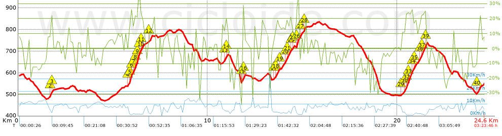
Distance in Km: 24.61
Climb in m: 1274
IBP: 261 RNG

Doni 81
Author: Doni 81
355 published routes

Add to my Group or Club

 Height in m      Climb in %      Speed in Km/h      Speed < 2 Km/h

Climbs > 10%

Climbs >5% Climbs >10% Climbs >15% Climbs >20% Climbs >25%
 Steep slope of 169 m.   Average slope  Distances  Download as waypoint
1
 Km 1.669  18%  34 m
2
 Km 1.703  21%  100 m
3
 Km 1.803  13%  35 m
 Steep slope of 1025 m.  Average slope  Distances  Download as waypoint
4
 Km 5.789  17%  96 m
5
 Km 5.885  29%  96 m
6
 Km 5.981  15%  95 m
7
 Km 6.076  23%  94 m
8
 Km 6.169  24%  126 m
9
 Km 6.295  33%  99 m
10
 Km 6.394  24%  94 m
11
 Km 6.487  15%  164 m
12
 Km 6.881  15%  161 m
 Steep slope of 168 m.  Average slope  Distances  Download as waypoint
13
 Km 10.913  19%  104 m
14
 Km 11.017  12%  64 m
 Steep slope of 133 m.  Average slope  Distances  Download as waypoint
15
 Km 11.804  30%  100 m
16
 Km 11.904  23%  33 m
 Steep slope of 1011 m.  Average slope  Distances  Download as waypoint
17
 Km 13.513  11%  65 m
18
 Km 13.578  17%  193 m
19
 Km 13.77  11%  327 m
20
 Km 14.097  19%  99 m
21
 Km 14.197  18%  133 m
22
 Km 14.329  20%  32 m
23
 Km 14.361  11%  63 m
24
 Km 14.424  16%  99 m
 Steep slope of 168 m.  Average slope  Distances  Download as waypoint
25
 Km 14.623  20%  32 m
26
 Km 14.655  33%  136 m
 Steep slope of 170 m.  Average slope  Distances  Download as waypoint
27
 Km 14.851  23%  72 m
28
 Km 15.083  21%  98 m
 Steep slope of 1293 m.  Average slope  Distances  Download as waypoint
29
 Km 20.204  11%  195 m
30
 Km 20.399  18%  32 m
31
 Km 20.431  24%  61 m
32
 Km 20.493  26%  102 m
33
 Km 20.594  24%  157 m
34
 Km 20.752  14%  160 m
35
 Km 20.911  14%  229 m
36
 Km 21.14  16%  99 m
37
 Km 21.239  22%  218 m
38
 Km 21.457  35%  37 m
39
 Km 21.494  23%  40 m
 Steep slope of 232 m.  Average slope  Distances  Download as waypoint
40
 Km 24.163  15%  232 m


Description of the route


Presence of ramps


 Climbs  Distance  % of the total  Speed  Your speed would be  Time  Your time would be
   15 - 30%  2.776  11.28  3.92  ?  0:42:30  ?
   10 - 15%  1.868  7.59  5.1  ?  0:21:59  ?
   5 - 10%  3.385  13.76  7.48  ?  0:27:10  ?
   1 - 5%  2.901  11.79  8.38  ?  0:20:46  ?
   Total*  11.261 Km  45.76 %  5.7 Km/h  ? Km/h    1:58:38 h  ? h  
 Flat
   1 - -1%  1.618 Km  6.58 %  9.94 Km/h  ? Km/h    0:09:46 h  ? h  
 Descents
   -1 - -5%  3.392  13.78  9.28  ?  0:21:56  ?
   -5 - -10%  3.115  12.66  9.66  ?  0:19:21  ?
   -10 - -15%  2.29  9.31  10.12  ?  0:13:35  ?
   -15 - -30%  2.472  10.04  8.63  ?  0:17:11  ?
   Total*  11.731 Km  47.67 %  9.34 Km/h  ? Km/h    1:15:22 h  ? h  
* The total has not necessarily coincide with the sum of the partials after correction of errors

How long would it take you?

How long would it take you to cover this route?
There are routes without a valid time information, but with your average stats you can assess the possible duration

Doni 81 to cover this route you've need a time of:   3:23:46 h 
If you sign in and have a minimum of two tracks of this same modality, you can know your time for this route, calculated from your stats..


 Detected activity type =  ()
 Penalization due to track conditions: 0 %   ( > 50 % = MTB, < 50 % = RDB)
 Reliability of the track: C   (1274/57/0/-/-/57)
 Correction level applied to the track: 0
DIFFICULTY OF THE ROUTE
IBP = 261 RNG
According to your statistics
 Your time in motion would be: ? h
Your average speed would be: ? Km/h
 

 Total Distance: 24.61 Km
 Analysed distance: 24.61 Km
 Linear distance: 0.85 Km

 Cumulated positive ramps: 1274 m  list of points info
 Cumulated negative ramps: 1305.5 m
 Maximum height: 835.2 m
 Minimum height: 469.4 m
 Climbing Ratio: 11.31 %
 Descent ratio: 11.13 %
 Cumulated postive ramps per Km: 51.77 m
 Cumulated negative ramps per Km: 53.05 m

 Total time: 3:23:46 h
 Time in movement: 3:23:46 h
 According to your statistics
 Your time in motion would be: ? h  
 Stopped time: 0:00:00 h
 Maximum slope filter: ~55 %
 Minimum separation analysed: ~30 m
 Number of points: 2125   (cad. 11.58 m)
 Significant waypoints: 707   (cad. 34.81 m / 33.27 %)

 Changes in direction per Km: 13.21
 Changes in direction > 5º por Km: 10.28
 Cumulated straight stretches: 2.876 Km
 Straight stretches per Km: 116.86 m
 Penalized slope changes: 16
 Penalized slope changes per Km: 0.65

 Average speed in total: 7.25 Km/h
 Average speed while moving: 7.25 Km/h
 According to your statistics
 Your average speed would be: ? Km/h  
 Maximum sustained speed: 37.18 Km/h


Comments

You can be the first one in commenting this route

 
My comments
:
Add comment  (Registered users)
 
Notify me answers to my comment  Do not notify answers to my comment


Share this route with a friend

Your friend will receive a message with a link to this page:
will see your email and your user name if you do it as registered user.


Write here your name (optional)

E-mail address of your friend(s). You can include various addresses separated by commas

Text or comment (optional) maximum 255 characters long, 255 Available characters

As a non registered users you need to fill-in the captcha text.
  Change image
Type the image characters.
 
 Share with a friend


Visited history

Delete history

Marked routes for review later or compare

My favorites


  Notify anomaly in this route Share in Facebook