tombatossal c.clubes 2018

Running
Running
Ref..: 519122
Published: 29/10/2018
Performed: 28/10/2018
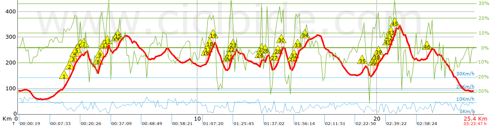
Distance in Km: 25.42
Climb in m: 1224
IBP: 248 RNG

Kikokiko00_Almazora
122 published routes

Add to my Group or Club

 Height in m      Climb in %      Speed in Km/h      Speed < 2 Km/h

Climbs > 10%

Climbs >5% Climbs >10% Climbs >15% Climbs >20% Climbs >25%
 Steep slope of 819 m.   Average slope  Distances  Download as waypoint
1
 Km 2.539  13%  365 m
2
 Km 2.903  17%  190 m
3
 Km 3.094  22%  33 m
4
 Km 3.126  14%  96 m
5
 Km 3.222  22%  33 m
6
 Km 3.42  16%  102 m
 Steep slope of 164 m.  Average slope  Distances  Download as waypoint
7
 Km 3.661  11%  164 m
 Steep slope of 291 m.  Average slope  Distances  Download as waypoint
8
 Km 4.48  24%  132 m
9
 Km 4.612  19%  127 m
10
 Km 4.739  15%  32 m
 Steep slope of 153 m.  Average slope  Distances  Download as waypoint
11
 Km 4.903  14%  32 m
12
 Km 4.935  22%  30 m
13
 Km 4.964  31%  91 m
 Steep slope of 194 m.  Average slope  Distances  Download as waypoint
14
 Km 5.458  11%  94 m
15
 Km 5.552  18%  100 m
 Steep slope of 131 m.  Average slope  Distances  Download as waypoint
16
 Km 10.512  17%  63 m
17
 Km 10.575  23%  126 m
18
 Km 10.701  15%  129 m
19
 Km 10.83  25%  60 m
 Steep slope of 348 m.  Average slope  Distances  Download as waypoint
20
 Km 11.717  12%  61 m
21
 Km 11.778  29%  96 m
22
 Km 11.874  18%  66 m
23
 Km 11.94  18%  31 m
 Steep slope of 122 m.  Average slope  Distances  Download as waypoint
24
 Km 13.467  25%  90 m
25
 Km 13.557  19%  32 m
 Steep slope of 130 m.  Average slope  Distances  Download as waypoint
26
 Km 13.753  19%  130 m
 Steep slope of 474 m.  Average slope  Distances  Download as waypoint
27
 Km 14.311  13%  129 m
28
 Km 14.44  23%  190 m
29
 Km 14.63  15%  64 m
30
 Km 14.694  17%  91 m
 Steep slope of 842 m.  Average slope  Distances  Download as waypoint
31
 Km 15.286  12%  129 m
32
 Km 15.415  22%  189 m
33
 Km 15.605  29%  32 m
34
 Km 15.963  13%  166 m
 Steep slope of 160 m.  Average slope  Distances  Download as waypoint
35
 Km 19.138  16%  160 m
 Steep slope of 823 m.  Average slope  Distances  Download as waypoint
36
 Km 19.732  12%  97 m
37
 Km 19.829  10%  96 m
38
 Km 19.925  20%  129 m
39
 Km 20.054  15%  32 m
40
 Km 20.578  14%  30 m
41
 Km 20.608  19%  32 m
42
 Km 20.64  22%  153 m
43
 Km 20.793  14%  130 m
44
 Km 20.923  33%  63 m
45
 Km 20.986  30%  29 m
 Steep slope of 198 m.  Average slope  Distances  Download as waypoint
46
 Km 22.736  13%  198 m


Description of the route


Presence of ramps


 Climbs  Distance  % of the total  Speed  Your speed would be  Time  Your time would be
   15 - 30%  2.72  10.7  4.11  ?  0:39:45  ?
   10 - 15%  2.206  8.68  5.62  ?  0:23:32  ?
   5 - 10%  2.77  10.9  7.46  ?  0:22:16  ?
   1 - 5%  3.494  13.75  9.71  ?  0:21:36  ?
   Total*  11.443 Km  45.02 %  6.14 Km/h  ? Km/h    1:51:47 h  ? h  
 Flat
   1 - -1%  1.741 Km  6.85 %  8.96 Km/h  ? Km/h    0:11:39 h  ? h  
 Descents
   -1 - -5%  3.608  14.19  10.1  ?  0:21:26  ?
   -5 - -10%  3.933  15.47  10.09  ?  0:23:23  ?
   -10 - -15%  1.942  7.64  9.21  ?  0:12:39  ?
   -15 - -30%  2.45  9.64  7.33  ?  0:20:03  ?
   Total*  12.234 Km  48.13 %  9.14 Km/h  ? Km/h    1:20:21 h  ? h  
* The total has not necessarily coincide with the sum of the partials after correction of errors

How long would it take you?

How long would it take you to cover this route?
There are routes without a valid time information, but with your average stats you can assess the possible duration

Kikokiko00_Almazora to cover this route you've need a time of:   3:23:47 h 
If you sign in and have a minimum of two tracks of this same modality, you can know your time for this route, calculated from your stats..


 Detected activity type =  ()
 Penalization due to track conditions: 0 %   ( > 50 % = MTB, < 50 % = RDB)
 Reliability of the track: B   (1224/63/0/-/-/63)
 Correction level applied to the track: 0
DIFFICULTY OF THE ROUTE
IBP = 248 RNG
According to your statistics
 Your time in motion would be: ? h
Your average speed would be: ? Km/h
 

 Total Distance: 25.42 Km
 Analysed distance: 25.42 Km
 Linear distance: 0.03 Km

 Cumulated positive ramps: 1223.86 m  list of points info
 Cumulated negative ramps: 1225.3 m
 Maximum height: 343.6 m
 Minimum height: 57.4 m
 Climbing Ratio: 10.7 %
 Descent ratio: 10.02 %
 Cumulated postive ramps per Km: 48.15 m
 Cumulated negative ramps per Km: 48.2 m

 Total time: 3:23:47 h
 Time in movement: 3:23:47 h
 According to your statistics
 Your time in motion would be: ? h  
 Stopped time: 0:00:00 h
 Maximum slope filter: ~55 %
 Minimum separation analysed: ~30 m
 Number of points: 2294   (cad. 11.08 m)
 Significant waypoints: 759   (cad. 33.49 m / 33.09 %)

 Changes in direction per Km: 14.56
 Changes in direction > 5º por Km: 11.57
 Cumulated straight stretches: 2.764 Km
 Straight stretches per Km: 108.73 m
 Penalized slope changes: 16
 Penalized slope changes per Km: 0.629

 Average speed in total: 7.48 Km/h
 Average speed while moving: 7.48 Km/h
 According to your statistics
 Your average speed would be: ? Km/h  
 Maximum sustained speed: 17.96 Km/h


Comments

You can be the first one in commenting this route

 
My comments
:
Add comment  (Registered users)
 
Notify me answers to my comment  Do not notify answers to my comment


Share this route with a friend

Your friend will receive a message with a link to this page:
will see your email and your user name if you do it as registered user.


Write here your name (optional)

E-mail address of your friend(s). You can include various addresses separated by commas

Text or comment (optional) maximum 255 characters long, 255 Available characters

As a non registered users you need to fill-in the captcha text.
  Change image
Type the image characters.
 
 Share with a friend


Visited history

Delete history

Marked routes for review later or compare

My favorites


  Notify anomaly in this route Share in Facebook