20181016 Vía Claudia Bolzano-Torbole

Road
Ref..: 508406
Published: 16/10/2018
Performed: 16/10/2018
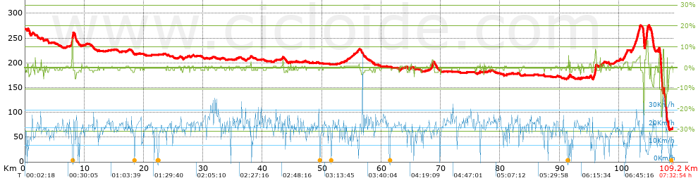
Distance in Km: 109.17
Climb in m: 334
IBP: 62 BYC
 View on STRAVA
Near ...
Bolzano, Bozen, Castelfirmiano, Sigmundskro
Bolzano, Bozen, Castelfirmiano, Sigmundskro

This route belongs to a multi-day journey 10 days documented with 10 independent routes
You can download the tracks of this multi-day route from each of the associated stages .| Day or stage | One day stage | Distance | Climb in | IBP |
| Day 1 | 504825 20181012 Vía Claudia Donauworth-Eresing | 85 Km | 235 m | 39 |
| Day 2 | 505790 20181013 Vía Claudia Eresing-Ehrwald | 124 Km | 1156 m | 111 |
| Day 3 | 506836 20181014 Vía Claudia Ehrwald-Nauders | 100 Km | 1260 m | 103 |
| Day 4 | 507931 20181015 Vía Claudia Nauders-Bolzano | 123 Km | 371 m | 69 |
| Day 5 | 508406 20181016 Vía Claudia Bolzano-Torbole (This) | 109 Km | 332 m | 62 |
| Day 6 | 509945 20181018 Camino a Roma Sirmione-Carpi | 106 Km | 60 m | 46 |
| Day 7 | 510758 20181019 Camino a Roma Carpi-Monzuno | 102 Km | 652 m | 79 |
| Day 8 | 511360 20181020 Camino a Roma Monzuno-Florencia | 88 Km | 1343 m | 100 |
| Day 9 | 516613 20181021 Camino a Roma Florencia-San Quirico d_Orcia | 124 Km | 1558 m | 119 |
| Day 10 | 513333 20181022 San Quirico d_Orcia-Viterbo | 114 Km | 1318 m | 97 |
| Total 10 days | 1075 Km | 8285 m | 83 / día |
Description of the route
Presence of ramps
| Climbs | Distance | % of the total | Speed | Your speed would be | Time | Your time would be | |
| 15 - 30% | 0.038 | 0.03 | 0 | ? | 0:00:00 | ? | |
| 10 - 15% | 0.389 | 0.36 | 7.95 | ? | 0:02:56 | ? | |
| 5 - 10% | 0.926 | 0.85 | 11.26 | ? | 0:04:56 | ? | |
| 1 - 5% | 10.145 | 9.29 | 14.63 | ? | 0:41:36 | ? | |
| Total* | 11.497 Km | 10.53 % | 13.95 Km/h | ?
Km/h  |
0:49:28 h | ? h |
|
| Flat | |||||||
| 1 - -1% | 82.147 Km | 75.24 % | 19.43 Km/h | ?
Km/h |
4:13:40 h | ? h |
|
| Descents | |||||||
| -1 - -5% | 13.494 | 12.36 | 14.75 | ? | 0:54:53 | ? | |
| -5 - -10% | 0.88 | 0.81 | 17.61 | ? | 0:03:00 | ? | |
| -10 - -15% | 0.505 | 0.46 | 9.68 | ? | 0:03:08 | ? | |
| -15 - -30% | 0.65 | 0.6 | 11.15 | ? | 0:03:30 | ? | |
| Total* | 15.53 Km | 14.23 % | 14.44 Km/h | ?
Km/h |
1:04:31 h | ? h |
|
How long would it take you?
 |
|
żCuanto consumirá tu E-BIKE?
Entra tu E-IBP (formato n,nn)
| Detected activity type = () |
| Penalization due to track conditions: 33 % ( > 50 % = MTB, < 50 % = RDB) |
|
|
Correction level applied to the track:
4
 See analyis without corrections See analyis without corrections
|
|
|
| DIFFICULTY OF THE ROUTE |
IBP = 62 BYC |
| According to your statistics Your time in motion would be: ? h |
| Your average speed would be:
? Km/h |
| Total Distance: 109.17 Km |
| Analysed distance: 109.17 Km |
| Linear distance: 79.66 Km |
| Cumulated positive ramps: 334.05 m |
list of points info |
| Cumulated negative ramps: 519.22 m | |
| Maximum height: 276.7 m | |
| Minimum height: 65.31 m | |
| Climbing Ratio: 2.91 % | |
| Descent ratio: 3.34 % | |
| Cumulated postive ramps per Km: 3.06 m | |
| Cumulated negative ramps per Km: 4.76 m | |
| Total time: 7:32:54 h |
| Time in movement: 6:07:39 h |
| According to your statistics Your time in motion would be: ? h
|
| Stopped time: 1:25:15 h |
| Maximum slope filter: ~30 % |
| Minimum separation analysed: ~30 m |
| Number of points: 8576 (cad. 12.73 m) |
| Significant waypoints: 2971 (cad. 36.75 m / 34.64 %) |
| Changes in direction per Km: 14.72 |
| Changes in direction > 5ş por Km: 6.12 |
| Cumulated straight stretches: 34.859 Km |
| Straight stretches per Km: 319.31 m |
| Penalized slope changes: 2 |
| Penalized slope changes per Km: 0.018 |
| Average speed in total: 14.46 Km/h |
| Average speed while moving: 17.82 Km/h |
| According to your statistics Your average speed would be: ? Km/h
|
| Maximum sustained speed: 41.57 Km/h |


