Pedraforca

MTB
MTB
Ref..: 428424
Published: 11/07/2018
Performed: 11/07/2018
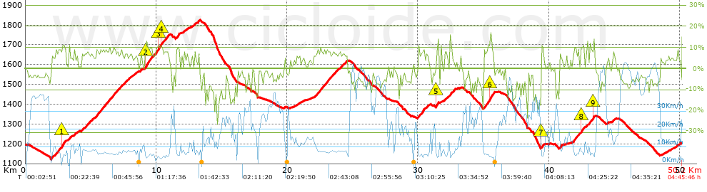
Distance in Km: 50.23
Climb in m: 1524
IBP: 97 BYC

Joxe_Marin
Author: Joxe_Marin
278 published routes

Add to my Group or Club

 Height in m      Climb in %      Speed in Km/h      Speed < 2 Km/h

Climbs > 5%

Climbs >5% Climbs >10% Climbs >15% Climbs >20% Climbs >25%
 Steep slope of 129 m.   Average slope  Distances  Download as waypoint
1
 Km 1.983  9%  129 m
 Steep slope of 812 m.  Average slope  Distances  Download as waypoint
2
 Km 2.221  8%  586 m
3
 Km 2.807  12%  161 m
4
 Km 2.968  10%  65 m
 Steep slope of 207 m.  Average slope  Distances  Download as waypoint
5
 Km 3.267  7%  207 m
 Steep slope of 172 m.  Average slope  Distances  Download as waypoint
6
 Km 3.744  7%  172 m
 Steep slope of 854 m.  Average slope  Distances  Download as waypoint
7
 Km 4.264  7%  854 m
 Steep slope of 2415 m.  Average slope  Distances  Download as waypoint
8
 Km 5.278  8%  2415 m
 Steep slope of 337 m.  Average slope  Distances  Download as waypoint
9
 Km 7.797  6%  337 m
 Steep slope of 230 m.  Average slope  Distances  Download as waypoint
10
 Km 8.299  5%  230 m
 Steep slope of 134 m.  Average slope  Distances  Download as waypoint
11
 Km 8.761  6%  134 m
 Steep slope of 1836 m.  Average slope  Distances  Download as waypoint
12
 Km 9.093  9%  95 m
13
 Km 9.187  11%  159 m
14
 Km 9.347  9%  775 m
15
 Km 10.122  11%  192 m
16
 Km 10.314  9%  97 m
17
 Km 10.41  10%  95 m
18
 Km 10.506  8%  423 m
 Steep slope of 234 m.  Average slope  Distances  Download as waypoint
19
 Km 11.528  10%  234 m
 Steep slope of 94 m.  Average slope  Distances  Download as waypoint
20
 Km 12.069  7%  94 m
 Steep slope of 166 m.  Average slope  Distances  Download as waypoint
21
 Km 12.262  6%  166 m
 Steep slope of 134 m.  Average slope  Distances  Download as waypoint
22
 Km 12.915  9%  134 m
 Steep slope of 162 m.  Average slope  Distances  Download as waypoint
23
 Km 13.151  8%  162 m
 Steep slope of 179 m.  Average slope  Distances  Download as waypoint
24
 Km 20.744  6%  179 m
 Steep slope of 2517 m.  Average slope  Distances  Download as waypoint
25
 Km 22.029  7%  2517 m
 Steep slope of 545 m.  Average slope  Distances  Download as waypoint
26
 Km 29.972  9%  545 m
 Steep slope of 126 m.  Average slope  Distances  Download as waypoint
27
 Km 30.65  8%  126 m
 Steep slope of 222 m.  Average slope  Distances  Download as waypoint
28
 Km 31.365  13%  191 m
29
 Km 31.556  6%  31 m
 Steep slope of 100 m.  Average slope  Distances  Download as waypoint
30
 Km 31.731  7%  100 m
 Steep slope of 230 m.  Average slope  Distances  Download as waypoint
31
 Km 32.002  6%  230 m
 Steep slope of 260 m.  Average slope  Distances  Download as waypoint
32
 Km 32.403  9%  260 m
 Steep slope of 842 m.  Average slope  Distances  Download as waypoint
33
 Km 35.006  9%  428 m
34
 Km 35.434  13%  191 m
35
 Km 35.625  10%  223 m
 Steep slope of 228 m.  Average slope  Distances  Download as waypoint
36
 Km 39.392  11%  131 m
37
 Km 39.523  8%  97 m
 Steep slope of 168 m.  Average slope  Distances  Download as waypoint
38
 Km 40.84  9%  168 m
 Steep slope of 472 m.  Average slope  Distances  Download as waypoint
39
 Km 41.821  8%  472 m
 Steep slope of 382 m.  Average slope  Distances  Download as waypoint
40
 Km 42.395  7%  33 m
41
 Km 42.428  10%  107 m
42
 Km 42.535  8%  242 m
 Steep slope of 546 m.  Average slope  Distances  Download as waypoint
43
 Km 42.922  8%  447 m
44
 Km 43.369  12%  99 m
 Steep slope of 122 m.  Average slope  Distances  Download as waypoint
45
 Km 44.459  5%  122 m
 Steep slope of 249 m.  Average slope  Distances  Download as waypoint
46
 Km 44.878  6%  249 m


Description of the route


Presence of ramps


 Climbs  Distance  % of the total  Speed  Your speed would be  Time  Your time would be
   15 - 30%  0.319  0.63  5.08  ?  0:03:46  ?
   10 - 15%  2.38  4.74  6.19  ?  0:23:04  ?
   5 - 10%  13.003  25.89  8.08  ?  1:36:30  ?
   1 - 5%  7.541  15.01  11.32  ?  0:39:58  ?
   Total*  23.243 Km  46.27 %  8.54 Km/h  ? Km/h    2:43:18 h  ? h  
 Flat
   1 - -1%  4.131 Km  8.22 %  16.31 Km/h  ? Km/h    0:15:12 h  ? h  
 Descents
   -1 - -5%  9.794  19.5  24.9  ?  0:23:36  ?
   -5 - -10%  8.613  17.15  33.27  ?  0:15:32  ?
   -10 - -15%  2.987  5.95  21.08  ?  0:08:30  ?
   -15 - -30%  1.462  2.91  10.76  ?  0:08:09  ?
   Total*  22.856 Km  45.5 %  24.58 Km/h  ? Km/h    0:55:47 h  ? h  
* The total has not necessarily coincide with the sum of the partials after correction of errors

How long would it take you?

How long would it take you to cover this route?
There are routes without a valid time information, but with your average stats you can assess the possible duration

Joxe_Marin to cover this route you've need a time of:   3:54:17 h 
If you sign in and have a minimum of two tracks of this same modality, you can know your time for this route, calculated from your stats..


¿Cuanto consumirá tu E-BIKE?

Entra tu E-IBP (formato n,nn)

E-IBP :   X 97 = 


 Detected activity type =  ()
 Penalization due to track conditions: 63 %   ( > 50 % = MTB, < 50 % = RDB)
 Reliability of the track: A   (1524/88/0/-/-/88)
 Correction level applied to the track: 0
DIFFICULTY OF THE ROUTE
IBP = 97 BYC
According to your statistics
 Your time in motion would be: ? h
Your average speed would be: ? Km/h
 

 Total Distance: 50.23 Km
 Analysed distance: 50.23 Km
 Linear distance: 0.01 Km

 Cumulated positive ramps: 1523.8 m  list of points info
 Cumulated negative ramps: 1517.07 m
 Maximum height: 1826.6 m
 Minimum height: 1122.4 m
 Climbing Ratio: 6.56 %
 Descent ratio: 6.64 %
 Cumulated postive ramps per Km: 30.34 m
 Cumulated negative ramps per Km: 30.2 m

 Total time: 4:45:46 h
 Time in movement: 3:54:17 h
 According to your statistics
 Your time in motion would be: ? h  
 Stopped time: 0:51:29 h
 Maximum slope filter: ~30 %
 Minimum separation analysed: ~30 m
 Number of points: 4100   (cad. 12.25 m)
 Significant waypoints: 1454   (cad. 34.55 m / 35.46 %)

 Changes in direction per Km: 10.79
 Changes in direction > 5º por Km: 8.14
 Cumulated straight stretches: 8.29 Km
 Straight stretches per Km: 165.04 m
 Penalized slope changes: 15
 Penalized slope changes per Km: 0.299

 Average speed in total: 10.55 Km/h
 Average speed while moving: 12.86 Km/h
 According to your statistics
 Your average speed would be: ? Km/h  
 Maximum sustained speed: 59.41 Km/h


Comments

You can be the first one in commenting this route

 
My comments
:
Add comment  (Registered users)
 
Notify me answers to my comment  Do not notify answers to my comment


Share this route with a friend

Your friend will receive a message with a link to this page:
will see your email and your user name if you do it as registered user.


Write here your name (optional)

E-mail address of your friend(s). You can include various addresses separated by commas

Text or comment (optional) maximum 255 characters long, 255 Available characters

As a non registered users you need to fill-in the captcha text.
  Change image
Type the image characters.
 
 Share with a friend


Visited history

Delete history

Marked routes for review later or compare

My favorites


  Notify anomaly in this route Share in Facebook