20180609 Castro-Laredo-Castro

Road
Road
Ref..: 409109
Published: 09/06/2018
Performed: 09/06/2018
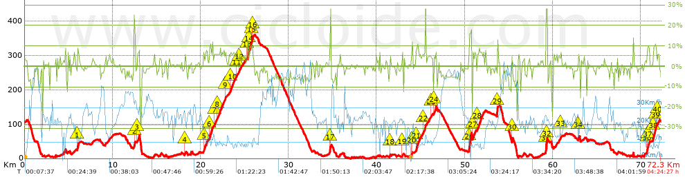
Distance in Km: 72.29
Climb in m: 1330
IBP: 99 BYC


 Height in m      Climb in %      Speed in Km/h      Speed < 2 Km/h

Climbs > 5%

Climbs >5% Climbs >10% Climbs >15% Climbs >20% Climbs >25%
 Steep slope of 178 m.   Average slope  Distances  Download as waypoint
1
 Km 5.971  10%  178 m
 Steep slope of 114 m.  Average slope  Distances  Download as waypoint
2
 Km 12.44  20%  114 m
 Steep slope of 266 m.  Average slope  Distances  Download as waypoint
3
 Km 12.805  8%  266 m
 Steep slope of 118 m.  Average slope  Distances  Download as waypoint
4
 Km 18.175  6%  118 m
 Steep slope of 437 m.  Average slope  Distances  Download as waypoint
5
 Km 20.324  7%  437 m
 Steep slope of 418 m.  Average slope  Distances  Download as waypoint
6
 Km 20.985  8%  418 m
 Steep slope of 216 m.  Average slope  Distances  Download as waypoint
7
 Km 21.521  6%  216 m
 Steep slope of 824 m.  Average slope  Distances  Download as waypoint
8
 Km 21.842  6%  824 m
 Steep slope of 111 m.  Average slope  Distances  Download as waypoint
9
 Km 22.765  7%  111 m
 Steep slope of 542 m.  Average slope  Distances  Download as waypoint
10
 Km 23.354  6%  542 m
 Steep slope of 144 m.  Average slope  Distances  Download as waypoint
11
 Km 24.013  7%  144 m
 Steep slope of 251 m.  Average slope  Distances  Download as waypoint
12
 Km 24.359  5%  251 m
 Steep slope of 102 m.  Average slope  Distances  Download as waypoint
13
 Km 25.251  7%  102 m
 Steep slope of 504 m.  Average slope  Distances  Download as waypoint
14
 Km 25.467  9%  291 m
15
 Km 25.758  11%  110 m
16
 Km 25.868  8%  103 m
 Steep slope of 120 m.  Average slope  Distances  Download as waypoint
17
 Km 34.686  19%  120 m
 Steep slope of 110 m.  Average slope  Distances  Download as waypoint
18
 Km 41.459  6%  110 m
 Steep slope of 150 m.  Average slope  Distances  Download as waypoint
19
 Km 42.894  8%  150 m
 Steep slope of 144 m.  Average slope  Distances  Download as waypoint
20
 Km 43.919  8%  144 m
 Steep slope of 401 m.  Average slope  Distances  Download as waypoint
21
 Km 44.434  8%  401 m
 Steep slope of 210 m.  Average slope  Distances  Download as waypoint
22
 Km 45.223  5%  210 m
 Steep slope of 98 m.  Average slope  Distances  Download as waypoint
23
 Km 46.149  5%  98 m
 Steep slope of 286 m.  Average slope  Distances  Download as waypoint
24
 Km 46.463  8%  286 m
 Steep slope of 323 m.  Average slope  Distances  Download as waypoint
25
 Km 50.453  12%  35 m
26
 Km 50.487  17%  288 m
 Steep slope of 366 m.  Average slope  Distances  Download as waypoint
27
 Km 50.884  6%  366 m
 Steep slope of 713 m.  Average slope  Distances  Download as waypoint
28
 Km 51.419  7%  713 m
 Steep slope of 120 m.  Average slope  Distances  Download as waypoint
29
 Km 53.668  23%  120 m
 Steep slope of 98 m.  Average slope  Distances  Download as waypoint
30
 Km 55.326  14%  98 m
 Steep slope of 169 m.  Average slope  Distances  Download as waypoint
31
 Km 59.196  14%  30 m
32
 Km 59.225  28%  139 m
 Steep slope of 118 m.  Average slope  Distances  Download as waypoint
33
 Km 60.883  6%  118 m
 Steep slope of 147 m.  Average slope  Distances  Download as waypoint
34
 Km 62.855  6%  147 m
 Steep slope of 333 m.  Average slope  Distances  Download as waypoint
35
 Km 70.657  9%  33 m
36
 Km 70.69  10%  111 m
37
 Km 70.801  9%  189 m
 Steep slope of 449 m.  Average slope  Distances  Download as waypoint
38
 Km 71.357  10%  259 m
39
 Km 71.616  9%  190 m
 Steep slope of 174 m.  Average slope  Distances  Download as waypoint
40
 Km 71.913  7%  174 m


Description of the route


Presence of ramps


 Climbs  Distance  % of the total  Speed  Your speed would be  Time  Your time would be
   15 - 30%  0.95  1.31  15.34  ?  0:03:43  ?
   10 - 15%  1.306  1.81  11.44  ?  0:06:51  ?
   5 - 10%  8.565  11.85  11.18  ?  0:45:57  ?
   1 - 5%  14.473  20.02  15.3  ?  0:56:45  ?
   Total*  25.295 Km  34.99 %  13.4 Km/h  ? Km/h    1:53:16 h  ? h  
 Flat
   1 - -1%  21.865 Km  30.25 %  22.34 Km/h  ? Km/h    0:58:43 h  ? h  
 Descents
   -1 - -5%  13.867  19.18  24.96  ?  0:33:20  ?
   -5 - -10%  8.916  12.33  35.16  ?  0:15:13  ?
   -10 - -15%  1.549  2.14  29.97  ?  0:03:06  ?
   -15 - -30%  0.795  1.1  24.45  ?  0:01:57  ?
   Total*  25.126 Km  34.76 %  28.13 Km/h  ? Km/h    0:53:36 h  ? h  
* The total has not necessarily coincide with the sum of the partials after correction of errors

How long would it take you?

How long would it take you to cover this route?
There are routes without a valid time information, but with your average stats you can assess the possible duration

pmiret58@gmail.com to cover this route you've need a time of:   3:45:35 h 
If you sign in and have a minimum of two tracks of this same modality, you can know your time for this route, calculated from your stats..


¿Cuanto consumirá tu E-BIKE?

Entra tu E-IBP (formato n,nn)

E-IBP :   X 99 = 


 Detected activity type =  ()
 Penalization due to track conditions: 56 %   ( > 50 % = MTB, < 50 % = RDB)
 Reliability of the track: B   (1345/61/0/-/-/61)
 Correction level applied to the track: 0
DIFFICULTY OF THE ROUTE
IBP = 99 BYC
According to your statistics
 Your time in motion would be: ? h
Your average speed would be: ? Km/h
 

 Total Distance: 72.29 Km
 Analysed distance: 72.29 Km
 Linear distance: 0 Km

 Cumulated positive ramps: 1329.71 m  list of points info
 Cumulated negative ramps: 1325.38 m
 Maximum height: 360.3 m
 Minimum height: -0.1 m
 Climbing Ratio: 5.26 %
 Descent ratio: 5.28 %
 Cumulated postive ramps per Km: 18.39 m
 Cumulated negative ramps per Km: 18.33 m

 Total time: 4:24:27 h
 Time in movement: 3:45:35 h
 According to your statistics
 Your time in motion would be: ? h  
 Stopped time: 0:38:52 h
 Maximum slope filter: ~30 %
 Minimum separation analysed: ~30 m
 Number of points: 5502   (cad. 13.14 m)
 Significant waypoints: 2005   (cad. 36.05 m / 36.44 %)

 Changes in direction per Km: 11.32
 Changes in direction > 5º por Km: 5.39
 Cumulated straight stretches: 20.186 Km
 Straight stretches per Km: 279.24 m
 Penalized slope changes: 12
 Penalized slope changes per Km: 0.166

 Average speed in total: 16.4 Km/h
 Average speed while moving: 19.23 Km/h
 According to your statistics
 Your average speed would be: ? Km/h  
 Maximum sustained speed: 62.49 Km/h


Comments

You can be the first one in commenting this route

 
My comments
:
Add comment  (Registered users)
 
Notify me answers to my comment  Do not notify answers to my comment


Share this route with a friend

Your friend will receive a message with a link to this page:
will see your email and your user name if you do it as registered user.


Write here your name (optional)

E-mail address of your friend(s). You can include various addresses separated by commas

Text or comment (optional) maximum 255 characters long, 255 Available characters

As a non registered users you need to fill-in the captcha text.
  Change image
Type the image characters.
 
 Share with a friend


Visited history

Delete history

Marked routes for review later or compare

My favorites


  Notify anomaly in this route Share in Facebook