Sortie à vélo matinale

MTB
MTB
Ref..: 393080
Published: 06/05/2018
Performed: 06/05/2018
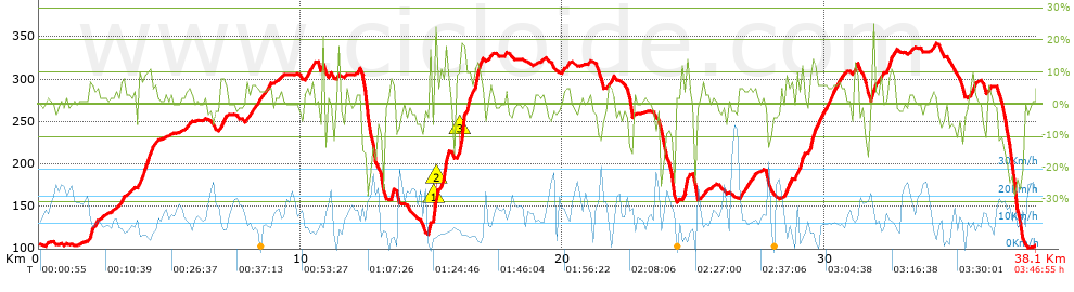
Distance in Km: 38.11
Climb in m: 961
IBP: 77 BYC

Doni 81
Author: Doni 81
355 published routes

Add to my Group or Club

 Height in m      Climb in %      Speed in Km/h      Speed < 2 Km/h

Climbs > 5%

Climbs >5% Climbs >10% Climbs >15% Climbs >20% Climbs >25%
 Steep slope of 162 m.   Average slope  Distances  Download as waypoint
1
 Km 1.924  8%  162 m
 Steep slope of 122 m.  Average slope  Distances  Download as waypoint
2
 Km 3.14  7%  122 m
 Steep slope of 573 m.  Average slope  Distances  Download as waypoint
3
 Km 3.663  5%  428 m
4
 Km 4.092  11%  145 m
 Steep slope of 243 m.  Average slope  Distances  Download as waypoint
5
 Km 6.918  7%  243 m
 Steep slope of 282 m.  Average slope  Distances  Download as waypoint
6
 Km 8.123  6%  282 m
 Steep slope of 158 m.  Average slope  Distances  Download as waypoint
7
 Km 10.275  5%  158 m
 Steep slope of 151 m.  Average slope  Distances  Download as waypoint
8
 Km 13.443  10%  151 m
 Steep slope of 316 m.  Average slope  Distances  Download as waypoint
9
 Km 14.903  14%  38 m
10
 Km 14.941  11%  156 m
11
 Km 15.097  28%  34 m
12
 Km 15.131  24%  29 m
13
 Km 15.16  22%  59 m
 Steep slope of 397 m.  Average slope  Distances  Download as waypoint
14
 Km 15.311  9%  161 m
15
 Km 15.471  18%  172 m
16
 Km 15.644  7%  64 m
 Steep slope of 963 m.  Average slope  Distances  Download as waypoint
17
 Km 15.912  6%  108 m
18
 Km 16.02  10%  34 m
19
 Km 16.054  18%  191 m
20
 Km 16.245  15%  169 m
21
 Km 16.414  6%  193 m
22
 Km 16.608  13%  218 m
23
 Km 16.825  10%  50 m
 Steep slope of 143 m.  Average slope  Distances  Download as waypoint
24
 Km 21.748  6%  143 m
 Steep slope of 268 m.  Average slope  Distances  Download as waypoint
25
 Km 24.527  9%  179 m
26
 Km 24.706  15%  89 m
 Steep slope of 226 m.  Average slope  Distances  Download as waypoint
27
 Km 26.747  6%  226 m
 Steep slope of 209 m.  Average slope  Distances  Download as waypoint
28
 Km 28.494  7%  209 m
 Steep slope of 252 m.  Average slope  Distances  Download as waypoint
29
 Km 28.923  9%  252 m
 Steep slope of 1149 m.  Average slope  Distances  Download as waypoint
30
 Km 29.444  9%  32 m
31
 Km 29.476  13%  183 m
32
 Km 29.659  6%  934 m
 Steep slope of 121 m.  Average slope  Distances  Download as waypoint
33
 Km 31.116  9%  121 m
 Steep slope of 114 m.  Average slope  Distances  Download as waypoint
34
 Km 31.793  16%  114 m
 Steep slope of 256 m.  Average slope  Distances  Download as waypoint
35
 Km 32.442  9%  256 m
 Steep slope of 142 m.  Average slope  Distances  Download as waypoint
36
 Km 35.605  9%  142 m


Description of the route


Presence of ramps


 Climbs  Distance  % of the total  Speed  Your speed would be  Time  Your time would be
   15 - 30%  0.768  2.02  7.14  ?  0:06:27  ?
   10 - 15%  1.561  4.1  6.4  ?  0:14:38  ?
   5 - 10%  4.913  12.89  8.39  ?  0:35:07  ?
   1 - 5%  9.707  25.47  11.12  ?  0:52:23  ?
   Total*  16.949 Km  44.48 %  9.37 Km/h  ? Km/h    1:48:35 h  ? h  
 Flat
   1 - -1%  7.964 Km  20.9 %  13.74 Km/h  ? Km/h    0:34:46 h  ? h  
 Descents
   -1 - -5%  6.872  18.03  14.43  ?  0:28:35  ?
   -5 - -10%  2.91  7.64  11.89  ?  0:14:41  ?
   -10 - -15%  1.693  4.44  13.7  ?  0:07:25  ?
   -15 - -30%  1.717  4.51  14.61  ?  0:07:03  ?
   Total*  13.193 Km  34.62 %  13.71 Km/h  ? Km/h    0:57:44 h  ? h  
* The total has not necessarily coincide with the sum of the partials after correction of errors

How long would it take you?

How long would it take you to cover this route?
There are routes without a valid time information, but with your average stats you can assess the possible duration

Doni 81 to cover this route you've need a time of:   3:21:05 h 
If you sign in and have a minimum of two tracks of this same modality, you can know your time for this route, calculated from your stats..


¿Cuanto consumirá tu E-BIKE?

Entra tu E-IBP (formato n,nn)

E-IBP :   X 77 = 


 Detected activity type =  ()
 Penalization due to track conditions: 72 %   ( > 50 % = MTB, < 50 % = RDB)
 Reliability of the track: B   (962/64/0/-/-/64)
 Correction level applied to the track: 0
DIFFICULTY OF THE ROUTE
IBP = 77 BYC
According to your statistics
 Your time in motion would be: ? h
Your average speed would be: ? Km/h
 

 Total Distance: 38.11 Km
 Analysed distance: 38.11 Km
 Linear distance: 0.01 Km

 Cumulated positive ramps: 961.43 m  list of points info
 Cumulated negative ramps: 974.53 m
 Maximum height: 342.4 m
 Minimum height: 100.8 m
 Climbing Ratio: 5.67 %
 Descent ratio: 7.39 %
 Cumulated postive ramps per Km: 25.23 m
 Cumulated negative ramps per Km: 25.57 m

 Total time: 3:46:55 h
 Time in movement: 3:21:05 h
 According to your statistics
 Your time in motion would be: ? h  
 Stopped time: 0:25:50 h
 Maximum slope filter: ~30 %
 Minimum separation analysed: ~30 m
 Number of points: 1359   (cad. 28.04 m)
 Significant waypoints: 818   (cad. 46.58 m / 60.19 %)

 Changes in direction per Km: 9.84
 Changes in direction > 5º por Km: 7.37
 Cumulated straight stretches: 5.351 Km
 Straight stretches per Km: 140.41 m
 Penalized slope changes: 12
 Penalized slope changes per Km: 0.315

 Average speed in total: 10.08 Km/h
 Average speed while moving: 11.37 Km/h
 According to your statistics
 Your average speed would be: ? Km/h  
 Maximum sustained speed: 46.15 Km/h


Comments

You can be the first one in commenting this route

 
My comments
:
Add comment  (Registered users)
 
Notify me answers to my comment  Do not notify answers to my comment


Share this route with a friend

Your friend will receive a message with a link to this page:
will see your email and your user name if you do it as registered user.


Write here your name (optional)

E-mail address of your friend(s). You can include various addresses separated by commas

Text or comment (optional) maximum 255 characters long, 255 Available characters

As a non registered users you need to fill-in the captcha text.
  Change image
Type the image characters.
 
 Share with a friend


Visited history

Delete history

Marked routes for review later or compare

My favorites


  Notify anomaly in this route Share in Facebook