De aventuras con el manitas Víctor

MTB
MTB
Ref..: 364075
Published: 04/03/2018
Performed: 04/03/2018
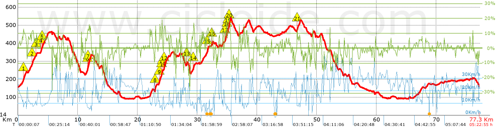
Distance in Km: 77.34
Climb in m: 1800
IBP: 142 BYC

Javi Mora
Author: Javi Mora
257 published routes

Add to my Group or Club

 Height in m      Climb in %      Speed in Km/h      Speed < 2 Km/h

Climbs > 10%

Climbs >5% Climbs >10% Climbs >15% Climbs >20% Climbs >25%
 Steep slope of 450 m.   Average slope  Distances  Download as waypoint
1
 Km 0.932  12%  167 m
2
 Km 2.339  11%  184 m
3
 Km 3.072  11%  99 m
 Steep slope of 275 m.  Average slope  Distances  Download as waypoint
4
 Km 3.826  10%  178 m
5
 Km 4.115  11%  97 m
 Steep slope of 584 m.  Average slope  Distances  Download as waypoint
6
 Km 11.655  14%  114 m
7
 Km 11.769  14%  470 m
 Steep slope of 171 m.  Average slope  Distances  Download as waypoint
8
 Km 22.951  16%  171 m
 Steep slope of 442 m.  Average slope  Distances  Download as waypoint
9
 Km 23.71  12%  344 m
10
 Km 24.054  17%  98 m
11
 Km 24.153  21%  36 m
 Steep slope of 360 m.  Average slope  Distances  Download as waypoint
12
 Km 24.418  13%  360 m
 Steep slope of 114 m.  Average slope  Distances  Download as waypoint
13
 Km 28.272  11%  114 m
 Steep slope of 145 m.  Average slope  Distances  Download as waypoint
14
 Km 29.411  15%  145 m
 Steep slope of 272 m.  Average slope  Distances  Download as waypoint
15
 Km 31.645  13%  272 m
 Steep slope of 135 m.  Average slope  Distances  Download as waypoint
16
 Km 32.424  10%  135 m
 Steep slope of 669 m.  Average slope  Distances  Download as waypoint
17
 Km 34.68  12%  240 m
18
 Km 34.92  11%  257 m
19
 Km 35.177  16%  213 m
20
 Km 35.389  15%  216 m
 Steep slope of 159 m.  Average slope  Distances  Download as waypoint
21
 Km 46.721  14%  112 m
 Steep slope of 184 m.  Average slope  Distances  Download as waypoint


Description of the route


Presence of ramps


 Climbs  Distance  % of the total  Speed  Your speed would be  Time  Your time would be
   15 - 30%  1.327  1.72  7.29  ?  0:10:55  ?
   10 - 15%  4.039  5.22  8.67  ?  0:27:58  ?
   5 - 10%  9.49  12.27  11.53  ?  0:49:22  ?
   1 - 5%  14.809  19.15  14.67  ?  1:00:33  ?
   Total*  29.665 Km  38.36 %  11.96 Km/h  ? Km/h    2:28:48 h  ? h  
 Flat
   1 - -1%  16.585 Km  21.44 %  21.81 Km/h  ? Km/h    0:45:37 h  ? h  
 Descents
   -1 - -5%  17.928  23.18  24.5  ?  0:43:54  ?
   -5 - -10%  7.619  9.85  25.66  ?  0:17:49  ?
   -10 - -15%  3.952  5.11  24.19  ?  0:09:48  ?
   -15 - -30%  1.587  2.05  23.81  ?  0:04:00  ?
   Total*  31.086 Km  40.2 %  24.7 Km/h  ? Km/h    1:15:31 h  ? h  
* The total has not necessarily coincide with the sum of the partials after correction of errors

How long would it take you?

How long would it take you to cover this route?
There are routes without a valid time information, but with your average stats you can assess the possible duration

Javi Mora to cover this route you've need a time of:   4:29:56 h 
If you sign in and have a minimum of two tracks of this same modality, you can know your time for this route, calculated from your stats..


¿Cuanto consumirá tu E-BIKE?

Entra tu E-IBP (formato n,nn)

E-IBP :   X 142 = 


 Detected activity type =  ()
 Penalization due to track conditions: 72 %   ( > 50 % = MTB, < 50 % = RDB)
 Reliability of the track: B   (1812/67/0/-/-/67)
 Correction level applied to the track: 0
DIFFICULTY OF THE ROUTE
IBP = 142 BYC
According to your statistics
 Your time in motion would be: ? h
Your average speed would be: ? Km/h
 

 Total Distance: 77.34 Km
 Analysed distance: 77.34 Km
 Linear distance: 0.03 Km

 Cumulated positive ramps: 1799.64 m  list of points info
 Cumulated negative ramps: 1791.64 m
 Maximum height: 540.4 m
 Minimum height: 89.6 m
 Climbing Ratio: 6.07 %
 Descent ratio: 5.76 %
 Cumulated postive ramps per Km: 23.27 m
 Cumulated negative ramps per Km: 23.17 m

 Total time: 5:22:55 h
 Time in movement: 4:29:56 h
 According to your statistics
 Your time in motion would be: ? h  
 Stopped time: 0:52:59 h
 Maximum slope filter: ~30 %
 Minimum separation analysed: ~30 m
 Number of points: 3117   (cad. 24.81 m)
 Significant waypoints: 1699   (cad. 45.52 m / 54.51 %)

 Changes in direction per Km: 9.48
 Changes in direction > 5º por Km: 6.87
 Cumulated straight stretches: 15.147 Km
 Straight stretches per Km: 195.85 m
 Penalized slope changes: 18
 Penalized slope changes per Km: 0.233

 Average speed in total: 14.37 Km/h
 Average speed while moving: 17.19 Km/h
 According to your statistics
 Your average speed would be: ? Km/h  
 Maximum sustained speed: 50.7 Km/h


Comments

You can be the first one in commenting this route

 
My comments
:
Add comment  (Registered users)
 
Notify me answers to my comment  Do not notify answers to my comment


Share this route with a friend

Your friend will receive a message with a link to this page:
will see your email and your user name if you do it as registered user.


Write here your name (optional)

E-mail address of your friend(s). You can include various addresses separated by commas

Text or comment (optional) maximum 255 characters long, 255 Available characters

As a non registered users you need to fill-in the captcha text.
  Change image
Type the image characters.
 
 Share with a friend


Visited history

Delete history

Marked routes for review later or compare

My favorites


  Notify anomaly in this route Share in Facebook