13 Tour Cyclotouriste, 14 Argelès - Gazost / Luz – Val Louron

Road
Road
Ref..: 3424
Published: 27/06/2010
Performed: 27/06/2010
Distance in Km: 102.45
Climb in m: 4872
IBP: 388 BYC   Drawn route

Agustí
Author: Agustí
174 published routes

Add to my Group or Club


Varios dias

This route belongs to a multi-day journey 21 days documented with 21 independent routes

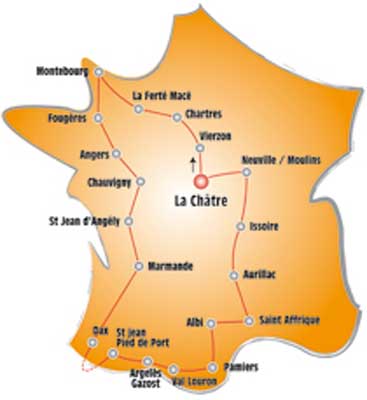
You can download the tracks of this multi-day route from each of the associated stages .
 Day or stage  One day stage  Distance  Climb in  IBP
 Day 1  
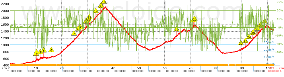
3410 13 Tour Cyclotouriste 1. La Châtre - > Vierzon  117 Km  1036 m  92
 Day 2  3411 13 Tour Cyclotouriste 2.vierzon - > Chartres  202 Km  1055 m  153
 Day 3  3412 13 Tour Cyclotouriste, 3 Chartres - > La Ferté - Macé  154 Km  1622 m  140
 Day 4  3413 13 Tour Cyclotouriste, 4 La Ferté - Macé - > Montebourg  187 Km  2352 m  204
 Day 5  3414 13 Tour Cyclotouriste, 5 Montebourg - > Montebourg  161 Km  2135 m  183
 Day 6  3415 13 Tour Cyclotouriste, 6 Montebourg – Fougères  170 Km  2096 m  178
 Day 7  3416 13 Tour Cyclotouriste, 7 Fougères – Angers  138 Km  1218 m  113
 Day 8  3417 13 Tour Cyclotouriste, 8 Angers – Chauvigny  184 Km  1513 m  159
 Day 9  3418 13 Tour Cyclotouriste, 9 Chauvigny – St Jean - D’angély  170 Km  1578 m  154
 Day 10  3420 13 Tour Cyclotouriste, 10 St Jean - D’angély – Marmande  221 Km  2395 m  224
 Day 11  3421 13 Tour Cyclotouriste, 11 Marmande – Dax  161 Km  980 m  123
 Day 12  3422 13 Tour Cyclotouriste, 12 Dax – St Jean - Pied - De - Port  138 Km  3402 m  278
 Day 13  3423 13 Tour Cyclotouriste, 13 St Jean - Pied - De - Port – Argelès - Gazost / Luz  144 Km  5395 m  443
 Day 14  3424 13 Tour Cyclotouriste, 14 Argelès - Gazost / Luz – Val Louron (This)  101 Km  4937 m  395
 Day 15  3425 13 Tour Cyclotouriste, 15 Val Louron – Pamiers  170 Km  5204 m  438
 Day 16  3426 13 Tour Cyclotouriste, 16 Pamiers – Albi  145 Km  2087 m  180
 Day 17  3427 13 Tour Cyclotouriste, 17 Albi – Saint - Affrique  97 Km  2878 m  238
 Day 18  3428 13 Tour Cyclotouriste, 18 Saint - Affrique – Aurillac  174 Km  5129 m  400
 Day 19  3429 13 Tour Cyclotouriste, 19 Aurillac – Issoire  155 Km  4487 m  365
 Day 20  3430 13 Tour Cyclotouriste, 20 Issoire – Moulin / Neuville  153 Km  1688 m  152
 Day 21  3431 13 Tour Cyclotouriste, 21 Moulin / Neuville – La Châtre  143 Km  1631 m  134
 Total 21 days  3285 Km  54818 m  226 / día

 Height in m      Climb in %      Speed in Km/h      Speed < 2 Km/h


Description of the route


1


Presence of ramps


 Climbs  Distance  % of the total  Speed  Your speed would be  Time  Your time would be
   15 - 30%  11.282  11.01  0  ?  0:00:00  ?
   10 - 15%  8.006  7.81  0  ?  0:00:00  ?
   5 - 10%  13.841  13.51  0  ?  0:00:00  ?
   1 - 5%  17.245  16.83  0  ?  0:00:00  ?
   Total*  50.373 Km  49.17 %  0 Km/h  ? Km/h    0:00:00 h  ? h  
 Flat
   1 - -1%  17.105 Km  16.7 %  0 Km/h  ? Km/h    0:00:00 h  ? h  
 Descents
   -1 - -5%  9.092  8.87  0  ?  0:00:00  ?
   -5 - -10%  9.46  9.23  0  ?  0:00:00  ?
   -10 - -15%  5.653  5.52  0  ?  0:00:00  ?
   -15 - -30%  10.768  10.51  0  ?  0:00:00  ?
   Total*  34.973 Km  34.14 %  0 Km/h  ? Km/h    0:00:00 h  ? h  
* The total has not necessarily coincide with the sum of the partials after correction of errors

How long would it take you?

How long would it take you to cover this route?
There are routes without a valid time information, but with your average stats you can assess the possible duration

Agustí to cover this route you've need a time of:   --- h 
If you sign in and have a minimum of two tracks of this same modality, you can know your time for this route, calculated from your stats..


¿Cuanto consumirá tu E-BIKE?

Entra tu E-IBP (formato n,nn)

E-IBP :   X 388 = 


 Detected activity type =  ()
 Penalization due to track conditions: 50 %   ( > 50 % = MTB, < 50 % = RDB)
 Reliability of the track: B   (4872/60/0/-/-/60)
 Correction level applied to the track: 0
DIFFICULTY OF THE ROUTE
IBP = 388 BYC
According to your statistics
 Your time in motion would be: ? h
Your average speed would be: ? Km/h
 

 Total Distance: 102.45 Km
 Analysed distance: 102.45 Km
 Linear distance: 46.58 Km

 Cumulated positive ramps: 4871.7 m  list of points info
 Cumulated negative ramps: 3927.3 m
 Maximum height: 2117 m
 Minimum height: 431 m
 Climbing Ratio: 9.67 %
 Descent ratio: 11.23 %
 Cumulated postive ramps per Km: 47.55 m
 Cumulated negative ramps per Km: 38.33 m

 Total time: --- h
 Time in movement: --- h
 According to your statistics
 Your time in motion would be: ? h  
 Stopped time: --- h
 Maximum slope filter: ~30 %
 Minimum separation analysed: ~30 m
 Number of points: 1428   (cad. 71.74 m)
 Significant waypoints: 1161   (cad. 88.24 m / 81.3 %)

 Changes in direction per Km: 5.86
 Changes in direction > 5º por Km: 5.23
 Cumulated straight stretches: 5.707 Km
 Straight stretches per Km: 55.71 m
 Penalized slope changes: 17
 Penalized slope changes per Km: 0.166

 Average speed in total: 0 Km/h
 Average speed while moving: 0 Km/h
 According to your statistics
 Your average speed would be: ? Km/h  
 Maximum sustained speed: 0 Km/h


Comments

You can be the first one in commenting this route

 
My comments
:
Add comment  (Registered users)
 
Notify me answers to my comment  Do not notify answers to my comment


Share this route with a friend

Your friend will receive a message with a link to this page:
will see your email and your user name if you do it as registered user.


Write here your name (optional)

E-mail address of your friend(s). You can include various addresses separated by commas

Text or comment (optional) maximum 255 characters long, 255 Available characters

As a non registered users you need to fill-in the captcha text.
  Change image
Type the image characters.
 
 Share with a friend


Visited history

Delete history

Marked routes for review later or compare

My favorites


  Notify anomaly in this route Share in Facebook